Maps of Appalachian Mountains
Etats-Unis d'Amerique.
1 : 4200000 Poussin, Guillaume Tell, 1794-1876
Mitchell's Reference & Distance Map Of The United States.
1 : 1584000 Young, James H.
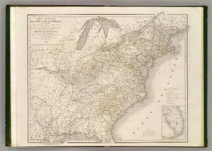
Verein-Staaten von Nord-America mit Ausnahme Florida's und der westlichen Territoirien
Hand-Atlas über alle Theile der Erde nach dem neuesten Zustande und über das Weltgebäude Stieler, Adolf bei Justus Perthes
Verein-Staaten von Nord-America mit Ausnahme Florida's und der westlichen Territoirien
Hand-Atlas über alle Theile der Erde und über das Weltgebäude Stieler, Adolf Justus Perthes
A diagram of the United States shewing the bearings and distances.
1 : 8350000 Melish, John
Chapin's Ornamental Map Of The United States.
1 : 2150000 Chapin, William
United States.
1 : 6000000 Colton, J. H.
Etats Unis de l'Amérique
1 : 13000000 gravé par Tardieu corr. et augm. en 1803 [Paris] : [s.n.]
United States Of North America.
1 : 1550000 Arrowsmith, Aaron
Reference & Distance Map Of The United States.
1 : 1584000 Young, James H.
United States of America.
1 : 5630000 Carey, Mathew
Map of the United States of America.
1 : 6019200 Maclure, William
Map of the United States of America.
1 : 6000000 Carey, Mathew
Map of the United States of America.
1 : 6019200 Melish, John
Mitchell's Reference & Distance Map Of The United States.
1 : 1584000 Young, James H.
[Kaart], uit: Appleton's spoorwegkaart van de Vereenigde Staten en Canada / door G.F. Thomas ; engraved by Rae Smith
1 : 3550000 titelvariant: Spoorwegkaart van de Vereenigde Staten en Canada; Annotatie: Oorspr. uitg. 1871 uitg. door D. Appleton G.F. Thomas fl. 1872; Smith, Rae Amsterdam : J.H. Laarman
Mitchell's map of the United States.
1 : 14752000 Mitchell, Samuel Augustus
United States.
1 : 10700000 Carey, Mathew
United States.
1 : 10700000 Carey, Mathew
Mitchell's Reference & Distance Map of the United States.
1 : 1584000 Young, James H.
United States Of North America.
1 : 1550000 Arrowsmith, Aaron
General-Karte der Vereinigten Staaten von Nord Amerika, nebst den grösst. Theilen von Canada & Tejas : mit Bezeichnung sämmtlicher Cantons, deren Haupt-u. Handelstädte, Eisenbahnen, Kunst- & Hauptstrassen, Canäle etc. etc.
1 : 3200000 nach den neuesten und besten New-Yorker Karten von J. Calvin Smith und H.S. Tanner, sowie nach Berghaus, Länder-& Völkerkunde entw. u. gez. von Albrecht Platt in Stein gest. u. gedr. im geogr. Institut von Albr. Platt ; in Stein gestochen v. Bomsdorf Magdeburg : Kaegelmann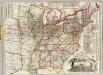
Watson's new rail-road and distance map of the United States and Canada.
1 : 2344320 Watson, Gaylord
Mitchell's Travellers Guide Through The United States.
1 : 14878700 Young, James H.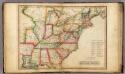
United States.
1 : 7603200 Melish, John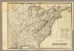
United States.
1 : 7603200 Melish, John
United States.
1 : 8363520 Burr, David H., 1803-1875
United States / by David H. Burr, New-York.
from Whole David H. Burr,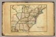
United States.
1 : 8000000 Seaman, James V.