Maps of Central Lowland

United States.
1 : 8363520 Burr, David H., 1803-1875
United States / by David H. Burr, New-York.
from Whole David H. Burr,
Union Military Chart.
Magnus, Charles
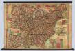
Colton's new railroad & county map of the United States, the Canadas &c.

Lines And Metallic Circuit Connections.
1 : 2155000 American Telephone and Telegraph Company
G. Woolworth Colton's new guide map of the United States & Canada : with railroads, counties etc.
1 : 3168000
United States.
1 : 11400000 Arrowsmith, Aaron; Lewis, Samuel
United States.
1 : 11400000 Lewis, Samuel
United States of America.
1 : 11960000 Tanner, Henry S.
Watson's new rail-road and distance map of the United States and Canada.
1 : 2344320 Watson, Gaylord
Colton's New Railroad & County Map Of The United States.
1 : 3041280 Colton, J. H.
Composite: Colton's New Railroad & County Map Of The United States.
1 : 3041280 Colton, J. H.
United States of America.
1 : 1960000 Tanner, Henry S.
United States of America.
1 : 1960000 Tanner, Henry S.
Lay's map of the United States / compiled from the latest and best authorities and actual surveys by Amos Lay, geographer and map publisher ; engraved by O.H. & D.S. Throop & Wm. Chapin.
from Whole
United States of America.
1 : 1960000 Tanner, Henry S.
A Connected View of The Whole Internal Navigation of the United States.
1 : 6082560 Tanner, Henry S.
United States of America.
1 : 1960000 Tanner, Henry S.
United States of America
1 : 2025000
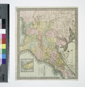
Map of the United States showing the land west of the Mississippi River still as Louisiana. Ohio is named as a state. Many Indian tribes and villages are named. A lead mine is located in today's northwestern Illinois. Florida is divided into the Spanish possessions of East and West Florida, Georgia extends to the Mississippi.

General-Karte der Vereinigten Staaten von Nord Amerika, nebst den grösst. Theilen von Canada & Tejas : mit Bezeichnung sämmtlicher Cantons, deren Haupt-u. Handelstädte, Eisenbahnen, Kunst- & Hauptstrassen, Canäle etc. etc.
1 : 3200000 nach den neuesten und besten New-Yorker Karten von J. Calvin Smith und H.S. Tanner, sowie nach Berghaus, Länder-& Völkerkunde entw. u. gez. von Albrecht Platt in Stein gest. u. gedr. im geogr. Institut von Albr. Platt ; in Stein gestochen v. Bomsdorf Magdeburg : Kaegelmann
Map of the United States.
1 : 2407680 Robinson, Lewis
U.S.A. (outline)
1 : 11800000 Patteson, Edward
U.S.A.
1 : 11800000 Patteson, Edward
A diagram of the United States shewing the bearings and distances.
1 : 8350000 Melish, John
Composite: United States.
1 : 1584000 Smith, J. Calvin
United States.
1 : 11700000 Adams, Daniel
Übersichtskarte über die Endmoräne der zweiten Glacialepoche Nord Amerikas nach T. C. Chamberlin 1882
1 : 15000000 gez. v. E. Geinitz aut. v. C. Schmidt Gotha : Perthes
Die Vereinigten Staaten von Nordamerika
1 : 4100000 Severní Amerika Sotzmann, Daniel Friedrich Arrowsmith, Aaron in der Schneider- und Weigelschen k. k. privilegirten Kunsthandlung