Maps of Appalachian Mountains

[Kaart], uit: Appleton's spoorwegkaart van de Vereenigde Staten en Canada / door G.F. Thomas ; engraved by Rae Smith
1 : 3550000 titelvariant: Spoorwegkaart van de Vereenigde Staten en Canada; Annotatie: Oorspr. uitg. 1871 uitg. door D. Appleton G.F. Thomas fl. 1872; Smith, Rae Amsterdam : J.H. Laarman
An accurate map of the United States of America: according to the Treaty of Peace of 1783.
from Whole Published as the Act directs by H.D. (Henry Delahoy) Symonds: London; Russell, John,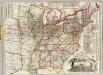
Watson's new rail-road and distance map of the United States and Canada.
1 : 2344320 Watson, Gaylord
A diagram of the United States shewing the bearings and distances.
1 : 8350000 Melish, John
United States.
1 : 1500000 Smith, J. Calvin
3. Population 1800.
1 : 16500000 Gannett, Henry, 1846-1914; United States. Census Office
7. Population 1840.
1 : 16500000 Gannett, Henry, 1846-1914; United States. Census Office
4. Population 1810.
1 : 16500000 Gannett, Henry, 1846-1914; United States. Census Office
8. Population 1850.
1 : 16500000 Gannett, Henry, 1846-1914; United States. Census Office
9. Population 1860.
1 : 16500000 Gannett, Henry, 1846-1914; United States. Census Office
5. Population 1820.
1 : 16500000 Gannett, Henry, 1846-1914; United States. Census Office
6. Population 1830.
1 : 16500000 Gannett, Henry, 1846-1914; United States. Census Office
2. Population 1790.
1 : 16500000 Gannett, Henry, 1846-1914; United States. Census Office
United States.
1 : 6000000 Colton, J. H.
Map of the United States, from the latest surveys with the heights of mountains and length of the principle rivers

Verein-Staaten von Nord-America mit Ausnahme Florida's und der westlichen Territoirien
Hand-Atlas über alle Theile der Erde nach dem neuesten Zustande und über das Weltgebäude Stieler, Adolf bei Justus Perthes
United States.
1 : 11400000 Arrowsmith, Aaron; Lewis, Samuel
United States.
1 : 11400000 Lewis, Samuel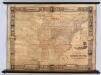
United States.
1 : 2471040 Munson, S. Bishop
Map of the United States showing the land west of the Mississippi River still as Louisiana. Ohio is named as a state. Many Indian tribes and villages are named. A lead mine is located in today's northwestern Illinois. Florida is divided into the Spanish possessions of East and West Florida, Georgia extends to the Mississippi.

Mitchell's map of the United States.
1 : 14752000 Mitchell, Samuel Augustus
4. Population 1830-1860.
1 : 8450000 Gannett, Henry, 1846-1914; United States. Census Office
3. Population 1790-1820.
1 : 8450000 Gannett, Henry, 1846-1914; United States. Census Office
Foreign population 1870.
1 : 7200000 Walker, Francis Amasa, 1840-1897
US Population 1850.
1 : 7100000 Walker, Francis Amasa, 1840-1897
Illiteracy 1870.
1 : 7100000 Walker, Francis Amasa, 1840-1897
Enteric, cerebro-spinal, typhus deaths.
1 : 7200000 Walker, Francis Amasa, 1840-1897
Foreign parentage 1870.
1 : 7100000 Walker, Francis Amasa, 1840-1897
Colored population proportion 1870.
1 : 7100000 Walker, Francis Amasa, 1840-1897
White male illiteracy.
1 : 7100000 Walker, Francis Amasa, 1840-1897
Predominating sex US.
1 : 7200000 Walker, Francis Amasa, 1840-1897
US Population 1860.
1 : 7100000 Walker, Francis Amasa, 1840-1897
US Population 1790-1820.
1 : 14300000 Walker, Francis Amasa, 1840-1897
Public indebtedness US.
1 : 7200000 Walker, Francis Amasa, 1840-1897
Consumption deaths US.
1 : 7200000 Walker, Francis Amasa, 1840-1897
Intestinal diseases deaths US.
1 : 7200000 Walker, Francis Amasa, 1840-1897
Malarial deaths US.
1 : 7200000 Walker, Francis Amasa, 1840-1897
Taxation per capita US.
1 : 7200000 Walker, Francis Amasa, 1840-1897
Wealth distribution US.
1 : 7200000 Walker, Francis Amasa, 1840-1897
Foreign population proportion 1870.
1 : 7200000 Walker, Francis Amasa, 1840-1897
Irish, German population 1870.
1 : 14300000 Walker, Francis Amasa, 1840-1897
Foreign parentage proportion 1870.
1 : 7100000 Walker, Francis Amasa, 1840-1897
Farms, production, corn, dairy.
1 : 14300000 Walker, Francis Amasa, 1840-1897
Crops US.
1 : 14300000 Walker, Francis Amasa, 1840-1897
Birth rate US.
1 : 7200000 Walker, Francis Amasa, 1840-1897
![[Kaart], uit: Appleton's spoorwegkaart van de Vereenigde Staten en Canada / door G.F. Thomas ; engraved by Rae Smith](https://images-2.georeferencer.com/images/iiif/129785456866/full/,300/0/native.jpg)

