Maps of Appalachian Mountains

Mitchell's map of the United States.
1 : 14752000 Mitchell, Samuel Augustus
[Kaart], uit: Appleton's spoorwegkaart van de Vereenigde Staten en Canada / door G.F. Thomas ; engraved by Rae Smith
1 : 3550000 titelvariant: Spoorwegkaart van de Vereenigde Staten en Canada; Annotatie: Oorspr. uitg. 1871 uitg. door D. Appleton G.F. Thomas fl. 1872; Smith, Rae Amsterdam : J.H. Laarman
New Map of the United States.
1 : 1584000 Young, James H.
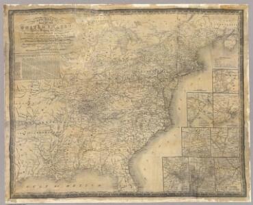
United States.
1 : 1500000 Smith, J. Calvin
United States.
1 : 6000000 Colton, J. H.
Map of the United States Of North America.
1 : 1837440 Burr, David H., 1803-1875
Karte der katholischen Diocesen und deren Missionen in Nordamerika nach den neuesten geographischen Angaben
1 : 22430000 Spojené státy americké-oblast východní Salzbacher, Joseph Engel, H. Joseph Salzbacher
Chapin's Ornamental Map Of The United States.
1 : 2150000 Chapin, William
United States Of North America.
1 : 1550000 Arrowsmith, Aaron
Alden's Pictorial Map Of The United States Of North America.
1 : 2851200 Alden, Albert
United States of America.
1 : 5950000 Thomson, John
United States.
1 : 11400000 Arrowsmith, Aaron; Lewis, Samuel
United States.
1 : 11400000 Lewis, Samuel
Etats Unis de l'Amérique
1 : 13000000 gravé par Tardieu corr. et augm. en 1803 [Paris] : [s.n.]
United States of America / drawn & engraved for Wardens Statistical account by W. & D. Lizars, Edinburgh
1 : 6000000 Annotatie: Uit: A statistical, political, and historical account of the United States of North America ... / D.B. Warden. - Edinburgh : Constable, 1819 William Lizars; Daniel Lizars [Edinburgh : A. Constable & Co.]
United States.
1 : 10400000 Lucas, Fielding Jr.
An accurate map of the United States of America: according to the Treaty of Peace of 1783.
from Whole Published as the Act directs by H.D. (Henry Delahoy) Symonds: London; Russell, John,
United States.
1 : 1500000 Smith, J. Calvin
CHARTE von den VEREINIGTEN STAATEN von NORD-AMERICA mit LUISIANA
Spojené státy americké-oblast východní
US Population 1830, 1840.
1 : 10040000 Walker, Francis Amasa, 1840-1897
United States.
1 : 8000000 Tanner, Henry S.
United States.
1 : 8000000 Tanner, Henry S.
United States.
1 : 10700000 Carey, Mathew
United States.
1 : 10700000 Carey, Mathew
Die Vereinigten Staaten von Nord-America

Composite: United States.
1 : 1584000 Smith, J. Calvin
United States

United States.
1 : 8050000 Tanner, Henry S.
United States Of North America.
1 : 1550000 Arrowsmith, Aaron