Maps of Appalachian Mountains

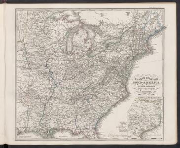
Verein-Staaten von Nord-America mit Ausnahme Florida's und der westlichen Territoirien
Hand-Atlas über alle Theile der Erde und über das Weltgebäude Stieler, Adolf Justus Perthes
Chapin's Ornamental Map Of The United States.
1 : 2150000 Chapin, William
Verein-Staaten von Nord-America mit Ausnahme Florida's und der westlichen Territoirien
Hand-Atlas über alle Theile der Erde nach dem neuesten Zustande und über das Weltgebäude Stieler, Adolf bei Justus Perthes
Etats-Unis d'Amerique.
1 : 4200000 Poussin, Guillaume Tell, 1794-1876
United States of Nth. America = Carte des Etats-unis de l'Amérique septentrionale / copiée et gravée sur celle d'Arrowsmith; corrigée et considérablement augmentée d'après les renseignemens les plus authentiques par P.F. Tardieu, graveur, editeur-propriétaire, Place de l'Estrapade, No. 18. à Paris, an XL 1802; ecrit par J.J. Pachoux; Chles. Picquet, géographe-graveur ...
from Parts P.F. Tardieu; J. J. Pachoux; Charles Picquet,
A diagram of the United States shewing the bearings and distances.
1 : 8350000 Melish, John
Etats Unis de l'Amérique
1 : 13000000 gravé par Tardieu corr. et augm. en 1803 [Paris] : [s.n.]
United States.
1 : 6000000 Colton, J. H.
A New Map of the United States.
1 : 1520640 Carleton, Osgood
United States Of North America.
1 : 1550000 Arrowsmith, Aaron
Map of the United States showing the land west of the Mississippi River still as Louisiana. Ohio is named as a state. Many Indian tribes and villages are named. A lead mine is located in today's northwestern Illinois. Florida is divided into the Spanish possessions of East and West Florida, Georgia extends to the Mississippi.

[Kaart], uit: Appleton's spoorwegkaart van de Vereenigde Staten en Canada / door G.F. Thomas ; engraved by Rae Smith
1 : 3550000 titelvariant: Spoorwegkaart van de Vereenigde Staten en Canada; Annotatie: Oorspr. uitg. 1871 uitg. door D. Appleton G.F. Thomas fl. 1872; Smith, Rae Amsterdam : J.H. Laarman
United States of America / drawn & engraved for Wardens Statistical account by W. & D. Lizars, Edinburgh
1 : 6000000 Annotatie: Uit: A statistical, political, and historical account of the United States of North America ... / D.B. Warden. - Edinburgh : Constable, 1819 William Lizars; Daniel Lizars [Edinburgh : A. Constable & Co.]
United States.
1 : 10700000 Carey, Mathew
United States.
1 : 10700000 Carey, Mathew
Reference & Distance Map Of The United States.
1 : 1584000 Young, James H.
Map of the United States
Lloyd, J. T.
Mitchell's Reference & Distance Map Of The United States.
1 : 1584000 Young, James H.
Mitchell's Travellers Guide Through The United States.
1 : 14878700 Young, James H.
United States of America.
1 : 1960000 Tanner, Henry S.
Composite: United States.
1 : 1584000 Smith, J. Calvin
United States of America.
1 : 5630000 Carey, Mathew
Map of the United States of America.
1 : 6019200 Maclure, William
Map of the United States of America.
1 : 6000000 Carey, Mathew
Map of the United States of America.
1 : 6019200 Melish, John
General-Karte der Vereinigten Staaten von Nord Amerika, nebst den grösst. Theilen von Canada & Tejas : mit Bezeichnung sämmtlicher Cantons, deren Haupt-u. Handelstädte, Eisenbahnen, Kunst- & Hauptstrassen, Canäle etc. etc.
1 : 3200000 nach den neuesten und besten New-Yorker Karten von J. Calvin Smith und H.S. Tanner, sowie nach Berghaus, Länder-& Völkerkunde entw. u. gez. von Albrecht Platt in Stein gest. u. gedr. im geogr. Institut von Albr. Platt ; in Stein gestochen v. Bomsdorf Magdeburg : Kaegelmann
United States Of North America.
1 : 1550000 Arrowsmith, Aaron
Watson's new rail-road and distance map of the United States and Canada.
1 : 2344320 Watson, Gaylord
Mitchell's map of the United States.
1 : 14752000 Mitchell, Samuel Augustus