Maps of Appalachian Mountains

Eastern United States.
1 : 4748000 Johnston, Alexander Keith
United States of America - East. Pergamon World Atlas.
1 : 5000000 Polish Army Topography Service
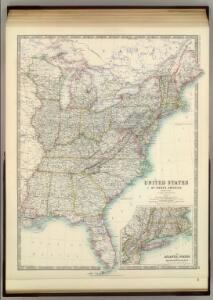
Eastern United States.
1 : 4748000 Johnston, Alexander Keith
United States.
1 : 5000000 Arrowsmith, John
United States E.
1 : 4748000 Johnston, Alexander Keith, 1804-1871
Map of the United States Of North America.
1 : 1837440 Burr, David H., 1803-1875
United States.
1 : 8050000 Tanner, Henry S.
United States.
1 : 11400000 Tanner, Henry S.
United States.
1 : 6200000 Hughes, William
United States.
1 : 2471040 Munson, S. Bishop
United States.
1 : 11400000 Finley, Anthony
Alden's Pictorial Map Of The United States Of North America.
1 : 2851200 Alden, Albert
United States.
1 : 1500000 Smith, J. Calvin
US Population 1830, 1840.
1 : 10040000 Walker, Francis Amasa, 1840-1897
United States.
1 : 8000000 Tanner, Henry S.
United States.
1 : 8000000 Tanner, Henry S.
New Map of the United States.
1 : 1584000 Young, James H.
United States.
1 : 11200000 Worcester, Joseph E.
United States.
1 : 8000000 Mitchell, Samuel Augustus
United States.
1 : 5068800 Arrowsmith, John
Mitchell's Reference & Distance Map Of The United States.
1 : 1584000 Young, James H.
United States.
1 : 10140000 Finley, Anthony
Map of the United States, from the latest surveys with the heights of mountains and length of the principle rivers

Population - United States census, 1870. Density, Foreign, Colored, British American, Swedish and Norwegian.
1 : 15000000 Baskin, Forster and Company
Population - United States census, 1870. Density, Foreign, Colored, British American, Swedish and Norwegian.
1 : 14000000 Andreas, A. T. (Alfred Theodore), 1839-1900
Population, United States Census, 1870: Density, foreign, colored, British American, Swedish and Norwegian.
Andreas, A. T. (Alfred Theodore), 1839-1900
Chapin's Ornamental Map Of The United States.
1 : 2217600 Taylor, J.B.
Carte Militaire des Etats - Unis (Partie Orientale).
1 : 5800000 Jouvet et Cie.
Map Of The United States.
1 : 11000000 Barber, John Warner