Maps of Great Rift Valley

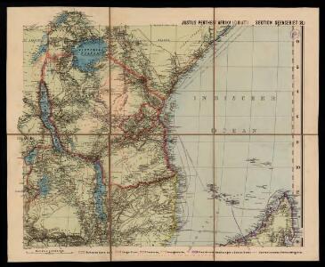
Spezial - karte von AfricaSektion Seengebiet (8)
1 : 4000000 1 full d'1 mapa en 10 fulls i estoig Hermann Habenicht; Justus Perthes
Spezial-Karte von Afrika
1 : 4000000 Blatt 8 Habenicht, Hermann Perthes
Die Ostküste Süd-Africa's nebst der Insel Madagascar, den Comoren, Sechellen, Amiranten und Mascarenischen Inseln
1 : 5480000 entworfen von C.F. Weiland gestochen von Mädel med. Weimar : Geographisches Institut
Die Ostküsten süd Africa nebs der Insel Madagascar, den Comoren, Sechellen, Amiranten und Mascarenischen Inseln
1 : 5000000 Komory Weiland, Karl Ferdinand Geograph. Instituts
Central Africa - eastern section.
1 : 5000000 John Bartholomew and Son
Charte von Nieder Guinea und den angrenzenden ländern Sud Afrika's : nach den neuesten und besten Hülfsmitteln
1 : 6750000 Reinecke, J. C. M. (Johann Christoph Matthias), 1770-1818 Im Verlage des Industrie Comptoirs
Central Africa (West). Central Africa (East).
1 : 10383000 W. & A.K. Johnston Limited
CHARTE von einem Theile der OST-KÜSTE VON Africa
Afrika východní
Charte von einem Theile der Ost-Küste von Africa
Afrika východní
Deutsch-Ostafrika
1 : 2000000 Afrika východní Moisel, Max Dietrich Reimer
Aequatorial-Ost-Afrika
1 : 3000000 Geographische Verlagshandlung Dietrich Reimer
Originalkarte von Burton's und Speke's Entdeckungen in Innerafrika 1857 u. 1858

Deutsch-Ostafrika
1 : 2000000 Keňa Rux, W. Just, P. Dietrich Reimer
Wirtschaftskarte von Deutsch-Afrika
1 : 2000000 Afrika východní Uhlig, Carl Moisel, Max Dietrich Reimer
Wirtschaftskarte von Deutsch-Afrika
1 : 2000000 Afrika východní Uhlig, Carl Moisel, Max Dietrich Reimer
Handkarte von Deutsch-Ostafrika
1 : 3000000 Afrika východní Kettler, Julius Iwan Riemer, C. Geographisches Institut
Handkarte von Deutsch-Ostafrika
1 : 3000000 Afrika východní Kettler, Julius Iwan Lindenlaub, A. Geographisches Institut
Handkarte von Deutsch-Ostafrika
1 : 3000000 Afrika východní Kettler, Julius Iwan Lindenlaub, A. Geographisches Institut
Deutsch-Ostafrika
1 : 4000000 Scobel, Albert
Übersichtskarte von Ost-Central-Afrika
Special Map of South-East Africa to Dr. David and Charles Livingstone's new mission travels

Übersichtskarte von Deutsch-Ostafrika
1 : 5000000 Afrika východní Dietrich Reimer
Východní polovice rovníkové Afriky s výzpytnými cestami po suchu a po vodě Henryho Stanleye v letech 1874-1877
1 : 3700000 Afrika střední
Karte von Speke's Reisen in Inner-Afrika
Carte des îles Comores
1 : 200000 France. Service géographique des colonies [Paris] : Ministère des Colonies
Mombasa-Victoria (Uganda) Railway and Busoga Railway
Mombasa--Victoria (Uganda) Railway and Busoga Railway. Scale, 1 : 1,500,000 or 1 inch = 23.67 miles.
Partie de Madagascar. Afrique 55.
1 : 1641836 Vandermaelen, Philippe, 1795-1869
Monoemugi. Afrique 40.
1 : 1641836 Vandermaelen, Philippe, 1795-1869
Zindgibar. Afrique 43.
1 : 1641836 Vandermaelen, Philippe, 1795-1869