Maps of Morogoro

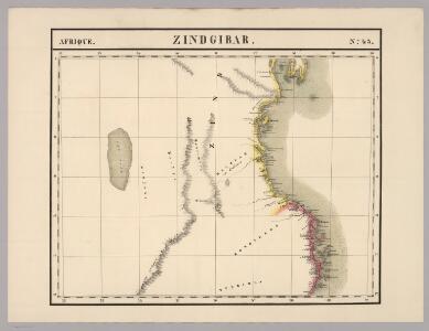
Zindgibar. Afrique 43.
1 : 1641836 Vandermaelen, Philippe, 1795-1869
[Map of the Nyassa expedition by Governor Oberst Freiherr von Schele:] Nyassa Expedition IV

Daressalam. German East Africa in 9 sheets, Sheet 6

Geologische Übersicht der Reisen des Bergassessors W. Bornhardt im Küstengebiet des mittleren Deutsch-Ostafrika
1 : 500000 Geographische Verlagshandlung Dietrich Reimer (Ernst Vohsen)
Geologische Übersicht der Reisen des Bergassessors W. Bornhardt zwischen Kilwa-Kivindye und dem Rovuma
1 : 500000 Geographische Verlagshandlung Dietrich Reimer (Ernst Vohsen)
Geologische Übersicht der Reise des Bergassessors W. Bornhardt von der Lindi-Bucht zum Nyassa
1 : 500000 Ost-Blatt Geographische Verlagshandlung Dietrich Reimer (Ernst Vohsen)
The estuarial area of River Rufiyi. Section taken from sheet E6 of the map of German East Africa

Geologische Übersicht der Reise des Bergassessors W. Bornhardt von der Lindi-Bucht zum Nyassa
1 : 500000 West-Blatt Geographische Verlagshandlung Dietrich Reimer (Ernst Vohsen)
the Kingani River from the estuary up to the Mafisi ferry

The Uluguru Mountains in German East Africa with the surrounding landscapes

Surveys by Hauptmann von Prittwitz and Gaffron in the Utshungwe Mountains (Uhehe) 1897 and 1898. Constructed and drawn by Max Moisel. Sheet I
The German Portuguese border region at the mouth of Ruvuma River. Surveyed in February 1895 by Dr. Franz Stuhlmann

Plan of Zanzibar (1904)
Plan of Zanzibar, IDWO 1014. Printed 1904. Surveyed by Imam Sharif KB of the Survey of India. Great Britain. War Office. Intelligence Division. [London] : [General Staff, Geographical Section]
Handkarte von Deutsch-Ostafrika
1 : 3000000 Afrika východní Kettler, Julius Iwan Riemer, C. Geographisches Institut
Handkarte von Deutsch-Ostafrika
1 : 3000000 Afrika východní Kettler, Julius Iwan Lindenlaub, A. Geographisches Institut
Handkarte von Deutsch-Ostafrika
1 : 3000000 Afrika východní Kettler, Julius Iwan Lindenlaub, A. Geographisches Institut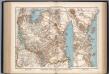
Deutsch-Ostafrika
1 : 4000000 Scobel, Albert
Übersichtskarte von Deutsch-Ostafrika
1 : 5000000 Afrika východní Dietrich Reimer
Versuch einer geologischen Karte des Njassagebietes
1 : 1000000 Annotatie: Bijlage (Krt. 1) bij: Mitteilungen aus den deutschen Schutzgebieten, Erganzungheft Nr. 10 (1914) Berlin : Mittler
Orographische Skizze des Njassagebietes
1 : 1000000 Annotatie: Bijlage (Krt. 2) bij: Mitteilungen aus den deutschen Schutzgebieten, Erganzungheft Nr. 10 (1914) Berlin : Mittler
Tanganyika, Africa 1:250,000 (Sheet 2)
Tanganyika, Africa 1:250,000. Shows cultivation areas over partially mapped base. -- Compiled from Directorate of Colonial Survey preliminary plots. Tanganyika. Department of Surveys and Town Planning. Dar es Salaam : Dept. of Surveys and Town Planning
Geologische Übersicht der Reisen des Bergassessors W. Bornhardt im Nyassa-Gebiet
1 : 500000 Geographische Verlagshandlung Dietrich Reimer (Ernst Vohsen)
Übersichtskarte von Ost-Central-Afrika

Deutsch-Ostafrika
1 : 2000000 Afrika východní Moisel, Max Dietrich Reimer
Aequatorial-Ost-Afrika
1 : 3000000 Geographische Verlagshandlung Dietrich Reimer
Spezial-Karte von Afrika
1 : 4000000 Blatt 8 Habenicht, Hermann Perthes
Originalkarte von Burton's und Speke's Entdeckungen in Innerafrika 1857 u. 1858

Central Africa - eastern section.
1 : 5000000 John Bartholomew and Son
CHARTE von einem Theile der OST-KÜSTE VON Africa
Afrika východní