Maps of Tanzania

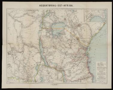
Aequatorial-Ost-Afrika
1 : 3000000 Geographische Verlagshandlung Dietrich Reimer
Originalkarte von Burton's und Speke's Entdeckungen in Innerafrika 1857 u. 1858

Central Africa - eastern section.
1 : 5000000 John Bartholomew and Son
Evangelische Mission im Kwango, Rep ZaireUebersichtsplan der Gemeinden und Aussenposten im Bezug zur Siedlungsdichte
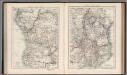
Central Africa (West). Central Africa (East).
1 : 10383000 W. & A.K. Johnston Limited
Stanley's Discoveries in Africa.
1 : 17500000 Colton, G.W.
Deutsch-Ostafrika
1 : 2000000 Afrika východní Moisel, Max Dietrich Reimer
Spezial-Karte von Afrika
1 : 4000000 Blatt 8 Habenicht, Hermann Perthes
Deutsch-Ostafrika
1 : 2000000 Keňa Rux, W. Just, P. Dietrich Reimer
Wirtschaftskarte von Deutsch-Afrika
1 : 2000000 Afrika východní Uhlig, Carl Moisel, Max Dietrich Reimer
Wirtschaftskarte von Deutsch-Afrika
1 : 2000000 Afrika východní Uhlig, Carl Moisel, Max Dietrich Reimer
Handkarte von Deutsch-Ostafrika
1 : 3000000 Afrika východní Kettler, Julius Iwan Riemer, C. Geographisches Institut
Handkarte von Deutsch-Ostafrika
1 : 3000000 Afrika východní Kettler, Julius Iwan Lindenlaub, A. Geographisches Institut
Handkarte von Deutsch-Ostafrika
1 : 3000000 Afrika východní Kettler, Julius Iwan Lindenlaub, A. Geographisches Institut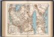
Deutsch-Ostafrika
1 : 4000000 Scobel, Albert
Übersichtskarte von Deutsch-Ostafrika
1 : 5000000 Afrika východní Dietrich Reimer
Východní polovice rovníkové Afriky s výzpytnými cestami po suchu a po vodě Henryho Stanleye v letech 1874-1877
1 : 3700000 Afrika střední
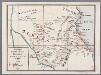
Karte von Speke's Reisen in Inner-Afrika

Mombasa-Victoria (Uganda) Railway and Busoga Railway
Mombasa--Victoria (Uganda) Railway and Busoga Railway. Scale, 1 : 1,500,000 or 1 inch = 23.67 miles.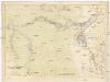
Routenkarte der Expedition zum Entsatze Emin Pascha's vom Kongo bis zum Victoria-Njasa
1 : 2267200 Afrika střední Stanley, Henry Morton F.A. Brockhaus
Zindgibar. Afrique 43.
1 : 1641836 Vandermaelen, Philippe, 1795-1869
Daressalam. German East Africa in 9 sheets, Sheet 6

Karte des Forschungs-Gebietes der Graf Samuel Telekíschen Expedition in Ost-Afrika 1887-88
1 : 1000000 Afrika východní Höhnel, Ludwig von Alfred Hölder
Kilimanjaro. Sheet 3.
Afrique 1:1,000,000
1 : 1000000 Kongo (Kinshasa) Établissement cartographique E. Patesson
Monoemugi. Afrique 40.
1 : 1641836 Vandermaelen, Philippe, 1795-1869
A map of the Albert N'yanza : and of the routes leading to its discovery
1 : 2100000 Baker, Samuel White, Sir, 1821-1893 Macmillan & Co
Haute Luapula secteur, Katanga district, Congo State (1906)
Map showing explorations and discoveries to June 1906, [...] Haute Luapula secteur, Katanga district, Congo State, TSGS 2354. Lithogravure of the Tanganyika Concessions (Mr Geo Grey's). Shows copper and tin mines. Great Britain. General Staff. Topographical Section. [London] : [TSGS, War Office]
[Map of the Nyassa expedition by Governor Oberst Freiherr von Schele:] Nyassa Expedition IV