Maps of Tanzania

Deutsch-Ostafrika
1 : 2000000 Afrika východní Moisel, Max Dietrich Reimer
Spezial-Karte von Afrika
1 : 4000000 Blatt 8 Habenicht, Hermann Perthes
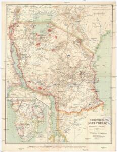
Deutsch-Ostafrika
1 : 2000000 Keňa Rux, W. Just, P. Dietrich Reimer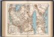
Deutsch-Ostafrika
1 : 4000000 Scobel, Albert
Handkarte von Deutsch-Ostafrika
1 : 3000000 Afrika východní Kettler, Julius Iwan Riemer, C. Geographisches Institut
Handkarte von Deutsch-Ostafrika
1 : 3000000 Afrika východní Kettler, Julius Iwan Lindenlaub, A. Geographisches Institut
Handkarte von Deutsch-Ostafrika
1 : 3000000 Afrika východní Kettler, Julius Iwan Lindenlaub, A. Geographisches Institut
Wirtschaftskarte von Deutsch-Afrika
1 : 2000000 Afrika východní Uhlig, Carl Moisel, Max Dietrich Reimer
Wirtschaftskarte von Deutsch-Afrika
1 : 2000000 Afrika východní Uhlig, Carl Moisel, Max Dietrich Reimer
Aequatorial-Ost-Afrika
1 : 3000000 Geographische Verlagshandlung Dietrich Reimer
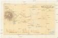
Übersichtskarte von Ost-Central-Afrika

Übersichtskarte von Deutsch-Ostafrika
1 : 5000000 Afrika východní Dietrich Reimer
Východní polovice rovníkové Afriky s výzpytnými cestami po suchu a po vodě Henryho Stanleye v letech 1874-1877
1 : 3700000 Afrika střední
Karte von Speke's Reisen in Inner-Afrika

Zindgibar. Afrique 43.
1 : 1641836 Vandermaelen, Philippe, 1795-1869
Mombasa-Victoria (Uganda) Railway and Busoga Railway
Mombasa--Victoria (Uganda) Railway and Busoga Railway. Scale, 1 : 1,500,000 or 1 inch = 23.67 miles.
Karte des Forschungs-Gebietes der Graf Samuel Telekíschen Expedition in Ost-Afrika 1887-88
1 : 1000000 Afrika východní Höhnel, Ludwig von Alfred Hölder
Kilimanjaro. Sheet 3.

Daressalam. German East Africa in 9 sheets, Sheet 6

Versuch einer geologischen Karte des Njassagebietes
1 : 1000000 Annotatie: Bijlage (Krt. 1) bij: Mitteilungen aus den deutschen Schutzgebieten, Erganzungheft Nr. 10 (1914) Berlin : Mittler
Orographische Skizze des Njassagebietes
1 : 1000000 Annotatie: Bijlage (Krt. 2) bij: Mitteilungen aus den deutschen Schutzgebieten, Erganzungheft Nr. 10 (1914) Berlin : Mittler
[Map of the Nyassa expedition by Governor Oberst Freiherr von Schele:] Nyassa Expedition IV

Monoemugi. Afrique 40.
1 : 1641836 Vandermaelen, Philippe, 1795-1869
Geologische Übersicht der Reisen des Bergassessors W. Bornhardt im Küstengebiet des mittleren Deutsch-Ostafrika
1 : 500000 Geographische Verlagshandlung Dietrich Reimer (Ernst Vohsen)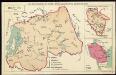
The mission areas of the Evangelical Mission Society for German East Africa [Bethel Mission]. Ruanda

Geologische Übersicht der Reisen des Bergassessors W. Bornhardt im Nyassa-Gebiet
1 : 500000 Geographische Verlagshandlung Dietrich Reimer (Ernst Vohsen)
Geologische Übersicht der Reisen des Bergassessors W. Bornhardt zwischen Kilwa-Kivindye und dem Rovuma
1 : 500000 Geographische Verlagshandlung Dietrich Reimer (Ernst Vohsen)
Geologische Übersicht der Reise des Bergassessors W. Bornhardt von der Lindi-Bucht zum Nyassa
1 : 500000 Ost-Blatt Geographische Verlagshandlung Dietrich Reimer (Ernst Vohsen)
Netzbild der Triangulationen 1:1 000 000
1 : 1000000 Afrika východní Dietrich Reimer