Maps of Iwembere Steppe

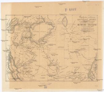
Východní polovice rovníkové Afriky s výzpytnými cestami po suchu a po vodě Henryho Stanleye v letech 1874-1877
1 : 3700000 Afrika střední
Mombasa-Victoria (Uganda) Railway and Busoga Railway
Mombasa--Victoria (Uganda) Railway and Busoga Railway. Scale, 1 : 1,500,000 or 1 inch = 23.67 miles.
Karte von Speke's Reisen in Inner-Afrika

Karte des Forschungs-Gebietes der Graf Samuel Telekíschen Expedition in Ost-Afrika 1887-88
1 : 1000000 Afrika východní Höhnel, Ludwig von Alfred Hölder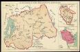
The mission areas of the Evangelical Mission Society for German East Africa [Bethel Mission]. Ruanda

Kilimanjaro. Sheet 3.
Graf Eduard Wickenburg's Reisetouren in Britisch-Ost-Afrika 1897-1898
1 : 500000 Keňa Paulitschke, Philipp G. Freytag & Berndt
Kilima-Ndscharo
1 : 800000 Kilimandžáro (Tanzanie : hora) F.A. Brockhaus' geogr.-artist. Anstalt
Die Ostafrikanische Bruchstufe von 1°40' bis 4°0' südl. Breite
1 : 150000 Tanzanie Uhlig, Carl Moisel, Max E.S. Mittler
Tanganyika, Africa 1:250,000 (Sheet 2)
Tanganyika, Africa 1:250,000. Shows cultivation areas over partially mapped base. -- Compiled from Directorate of Colonial Survey preliminary plots. Tanganyika. Department of Surveys and Town Planning. Dar es Salaam : Dept. of Surveys and Town Planning
German East Africa. [Showing the districts of Korogwe, Moa, Tanga and Wilhelmstal.]
German East Africa. [Showing the districts of Korogwe, Moa, Tanga and Wilhelmstal.] Scale, 1 : 100,000. [London] : [Geographical Section, General Staff].
Tanganyika 1:50,000, Series GSGS4789 (B)
Tanganyika 1:50,000, Series GSGS4789. Great Britain. Directorate of Colonial Surveys. [London] : War Office.
German East Africa. Map 1. East Usambara. 1897-1899. Trigonometric and topographically surveyed, calculated and drawn by H. Böhler

General layout of Dar Es Salaam [and] Bagamoyo [and] surroundings of Pangani [and] plan of Tanga Bay

Kenya 1:50,000 (Sheet 118/IV)
Kenya 1:50,000, Series GSGS 4786. Also issued by Directorate of Colonial Surveys as DCS 23 (later DOS 423). Great Britain. Directorate of Colonial Surveys. Nairobi : Survey of Kenya.
Kenya 1:50,000, G.S.G.S. 4786, Marmanet Forest
Kenya 1:50,000, G.S.G.S. 4786. Compiled and drawn by Directorate of Colonial Surveys. Reproduced by War Office, 1953 from D.C.S. 23 Preliminary Plot. [London] : War Office
Kenya 1:50,000 (Sheet 103/II)
Kenya 1:50,000, Series GSGS 4786. Also issued by Directorate of Colonial Surveys as DCS 23 (later DOS 423). Great Britain. Directorate of Colonial Surveys. Nairobi : Survey of Kenya.
Kenya 1:50,000 (Sheet 120/III)
Kenya 1:50,000, Series GSGS 4786. Also issued by Directorate of Colonial Surveys as DCS 23 (later DOS 423). Great Britain. Directorate of Colonial Surveys. Nairobi : Survey of Kenya.
East Africa (Mombasa) defence scheme map
East Africa (Mombasa) defence scheme map, IDWO 1891. Overprinted on monochrome Admiralty Chart, this map shows beacons, submarine cables and potential landing sights. Covers Mombasa island and surrounding estuaries. Originally classified Secret"." Great Britain. War Office. Intelligence Division. [London] : [War Office, Intelligence Division]
Plan of Zanzibar (1904)
Plan of Zanzibar, IDWO 1014. Printed 1904. Surveyed by Imam Sharif KB of the Survey of India. Great Britain. War Office. Intelligence Division. [London] : [General Staff, Geographical Section]
Kenya 1:50,000 (Sheet 89/III)
Kenya 1:50,000, Series GSGS 4786. Also issued by Directorate of Colonial Surveys as DCS 23 (later DOS 423). Great Britain. Directorate of Colonial Surveys. Nairobi : Survey of Kenya.
Wirtschaftskarte von Deutsch-Afrika
1 : 2000000 Afrika východní Uhlig, Carl Moisel, Max Dietrich Reimer
Wirtschaftskarte von Deutsch-Afrika
1 : 2000000 Afrika východní Uhlig, Carl Moisel, Max Dietrich Reimer
Deutsch-Ostafrika
1 : 2000000 Keňa Rux, W. Just, P. Dietrich Reimer
Deutsch-Ostafrika
1 : 2000000 Afrika východní Moisel, Max Dietrich Reimer
Handkarte von Deutsch-Ostafrika
1 : 3000000 Afrika východní Kettler, Julius Iwan Riemer, C. Geographisches Institut
Handkarte von Deutsch-Ostafrika
1 : 3000000 Afrika východní Kettler, Julius Iwan Lindenlaub, A. Geographisches Institut
Handkarte von Deutsch-Ostafrika
1 : 3000000 Afrika východní Kettler, Julius Iwan Lindenlaub, A. Geographisches Institut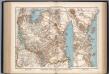
Deutsch-Ostafrika
1 : 4000000 Scobel, Albert