Maps of Mozambique
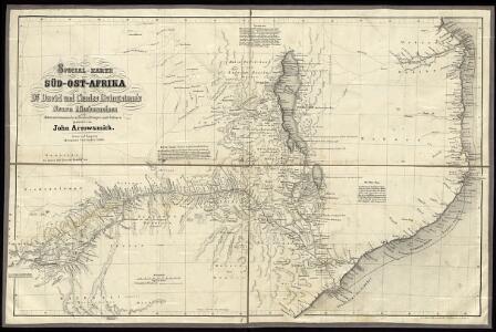
Special Map of South-East Africa to Dr. David and Charles Livingstone's new mission travels

Map of Portuguese East Africa
1 : 3000000 Afrika východní Mining and Industrial Publications of Africa
Afrique, cote orientale.
1 : 7000000 Bonne, Rigobert, 1727-1794
Übersichtskarte von Ost-Central-Afrika
Central Africa (West). Central Africa (East).
1 : 10383000 W. & A.K. Johnston Limited
Deutsch-Ostafrika
1 : 2000000 Afrika východní Moisel, Max Dietrich Reimer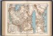
Deutsch-Ostafrika
1 : 4000000 Scobel, Albert
Übersichtskarte von Deutsch-Ostafrika
1 : 5000000 Afrika východní Dietrich Reimer
Deutsch-Ostafrika
1 : 2000000 Keňa Rux, W. Just, P. Dietrich Reimer
Jesuit mission of northern Rhodesia
1 : 1500000 Zambie Dittrich, Reinhold
Wirtschaftskarte von Deutsch-Afrika
1 : 2000000 Afrika východní Uhlig, Carl Moisel, Max Dietrich Reimer
Wirtschaftskarte von Deutsch-Afrika
1 : 2000000 Afrika východní Uhlig, Carl Moisel, Max Dietrich Reimer
Handkarte von Deutsch-Ostafrika
1 : 3000000 Afrika východní Kettler, Julius Iwan Riemer, C. Geographisches Institut
Handkarte von Deutsch-Ostafrika
1 : 3000000 Afrika východní Kettler, Julius Iwan Lindenlaub, A. Geographisches Institut
Handkarte von Deutsch-Ostafrika
1 : 3000000 Afrika východní Kettler, Julius Iwan Lindenlaub, A. Geographisches Institut
Mononomatapa. Afrique 46.
1 : 1641836 Vandermaelen, Philippe, 1795-1869
Mocaranga. Afrique 49.
1 : 1641836 Vandermaelen, Philippe, 1795-1869
Mozambique (Limpopo Zanzibar) Scale, 1 : 2,000,000
Mozambique. (Limpopo. Zanzibar.) Scale, 1 : 2,000,000. Compiled at the Royal Geographical Society under the direction of the Geographical Section, General Staff. This map forms part of the collection of maps in a case issued to accompany the Manual of Portuguese East Africa," compiled by the Naval Staff of the Admiralty." London : War Office
Versuch einer geologischen Karte des Njassagebietes
1 : 1000000 Annotatie: Bijlage (Krt. 1) bij: Mitteilungen aus den deutschen Schutzgebieten, Erganzungheft Nr. 10 (1914) Berlin : Mittler
172. Central Africa Mining Region. The World Atlas.
1 : 2500000 USSR (Union of Soviet Socialist Republics).
Zindgibar. Afrique 43.
1 : 1641836 Vandermaelen, Philippe, 1795-1869
Daressalam. German East Africa in 9 sheets, Sheet 6

Podrobná mapa cest D.ra Holuba (čís. 1.) po střední části země východních Bamankvatův a západních Matabelův
1 : 500000 Botswana Holub, Emil nákladem J. Otty
Orographische Skizze des Njassagebietes
1 : 1000000 Annotatie: Bijlage (Krt. 2) bij: Mitteilungen aus den deutschen Schutzgebieten, Erganzungheft Nr. 10 (1914) Berlin : Mittler
[Map of the Nyassa expedition by Governor Oberst Freiherr von Schele:] Nyassa Expedition IV

Geologische Übersicht der Reisen des Bergassessors W. Bornhardt im Küstengebiet des mittleren Deutsch-Ostafrika
1 : 500000 Geographische Verlagshandlung Dietrich Reimer (Ernst Vohsen)
Geologische Übersicht der Reisen des Bergassessors W. Bornhardt im Nyassa-Gebiet
1 : 500000 Geographische Verlagshandlung Dietrich Reimer (Ernst Vohsen)
Geologische Übersicht der Reisen des Bergassessors W. Bornhardt zwischen Kilwa-Kivindye und dem Rovuma
1 : 500000 Geographische Verlagshandlung Dietrich Reimer (Ernst Vohsen)
Geologische Übersicht der Reise des Bergassessors W. Bornhardt von der Lindi-Bucht zum Nyassa
1 : 500000 Ost-Blatt Geographische Verlagshandlung Dietrich Reimer (Ernst Vohsen)