Maps of Mozambique

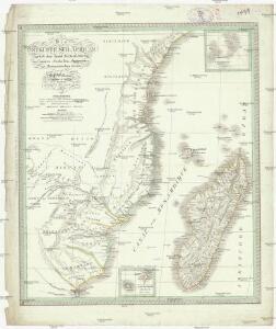
Die Ostküsten süd Africa nebs der Insel Madagascar, den Comoren, Sechellen, Amiranten und Mascarenischen Inseln
1 : 5000000 Komory Weiland, Karl Ferdinand Geograph. Instituts
Die Ostküste Süd-Africa's nebst der Insel Madagascar, den Comoren, Sechellen, Amiranten und Mascarenischen Inseln
1 : 5480000 entworfen von C.F. Weiland gestochen von Mädel med. Weimar : Geographisches Institut
CHARTE von einem Theile der OST-KÜSTE VON Africa
Afrika východní
Charte von einem Theile der Ost-Küste von Africa
Afrika východní
Spezial - karte von AfricaSektion Seengebiet (8)
1 : 4000000 1 full d'1 mapa en 10 fulls i estoig Hermann Habenicht; Justus Perthes
Spezial-Karte von Afrika
1 : 4000000 Blatt 8 Habenicht, Hermann Perthes
Afrique, cote orientale.
1 : 7000000 Bonne, Rigobert, 1727-1794
Charte von Nieder Guinea und den angrenzenden ländern Sud Afrika's : nach den neuesten und besten Hülfsmitteln
1 : 6750000 Reinecke, J. C. M. (Johann Christoph Matthias), 1770-1818 Im Verlage des Industrie Comptoirs
Übersichtskarte von Ost-Central-Afrika

INSVLA S. LAVRENTII, | Vulgo | MADAGASCAR.
[Amsterdam : Joan Blaeu]
Map of Portuguese East Africa
1 : 3000000 Afrika východní Mining and Industrial Publications of Africa
Carte de l'ile de Madagascar
1 : 4500000 réd. par B.F. Leguével de la Combe d'après ses reconnaissances, ses itinéraires, et les cartes du Depôt de la Marine dressée par A. H. Dufour ; la topographie par Felix Charpentier ; la lettre par Ch. Simon Paris : chez Desessart
Central Africa - eastern section.
1 : 5000000 John Bartholomew and Son
Special Map of South-East Africa to Dr. David and Charles Livingstone's new mission travels
Central Africa (West). Central Africa (East).
1 : 10383000 W. & A.K. Johnston Limited
Deutsch-Ostafrika
1 : 2000000 Afrika východní Moisel, Max Dietrich Reimer
Handkarte von Deutsch-Ostafrika
1 : 3000000 Afrika východní Kettler, Julius Iwan Riemer, C. Geographisches Institut
Handkarte von Deutsch-Ostafrika
1 : 3000000 Afrika východní Kettler, Julius Iwan Lindenlaub, A. Geographisches Institut
Handkarte von Deutsch-Ostafrika
1 : 3000000 Afrika východní Kettler, Julius Iwan Lindenlaub, A. Geographisches Institut
Wirtschaftskarte von Deutsch-Afrika
1 : 2000000 Afrika východní Uhlig, Carl Moisel, Max Dietrich Reimer
Wirtschaftskarte von Deutsch-Afrika
1 : 2000000 Afrika východní Uhlig, Carl Moisel, Max Dietrich Reimer
Topographical map of the Island of Madagascar
1 : 4580000 from the original design drawn on the spot by M. Roberts S.I. Neele sculpt. London : [s.n.]
Madagascar
Vidal de La Blache, Paul
Spezial-Karte von Afrika
1 : 4000000 Blatt 10 Habenicht, Hermann Perthes
Deutsch-Ostafrika
1 : 2000000 Keňa Rux, W. Just, P. Dietrich Reimer
Carte Particuliere De L'Isle Dauphine ou Madagascar Et St. Laurens, Levée Par Ordre Expres des Roys De Portugal sous qui on en a Fait la Decouverte. [Karte], in: Atlas nouveau, contenant toutes les parties du monde [...], Bd. 2, S. 225.
1 Karte aus Atlas Sanson, Nicolas Jaillot, Alexis Hubert und Mortier, Pieter
Aequatorial-Ost-Afrika
1 : 3000000 Geographische Verlagshandlung Dietrich Reimer
Carte de Madagascar / publiée par le Service Géographique de l'Armée
1 : 2000000 Annotatie geografische gegevens: Inzetkrt.: Partie sud de Nosy-Bé. - 1:200.000; Baie de Diego-Suarez. - 1:200.000 Service Géographique de l'Armée [S.l. : Service Géographique de l'Armée]
Madagascar.
1 : 2661120 Stanford, Edward