Maps of British Isles

Angliae Regni Florentissimi Nova Descriptio [...] [Karte], in: Theatrum orbis terrarum, S. 36.
1 Karte aus Atlas Ortelius, Abraham
Anglia regnum [Karte], in: Atlas, sive, Cosmographicae meditationes de fabrica mundi et fabricati figura, S. 107.
1 Karte aus Atlas Mercator, Gerhard
Anglia regnum [Karte], in: Gerardi Mercatoris Atlas, sive, Cosmographicae meditationes de fabrica mundi et fabricati figura, S. 109.
1 Karte aus Atlas Mercator, Gerhard Montanus, Petrus
Typus Angliae
This is a map of the British Isles by Jodocus Hondius, it dates from 1590 and was probably published in London where Hondius was resident for about 10 years from 1583. The map is dedicated to Robert, Earl of Essex in a small panel below Ireland. The outline of the England and Wales follows that of Saxton, with Ireland being a crude version of Ortelius's outline. Only a small section of Scotland is shown. Emphasis is placed on the decorative elements of the map. Surmounting the oval shaped map is a portrait of Queen Elizabeth I. She is flanked by text plaques on each side which contain biblical text praising the Queen and text hailing the prosperity of the realm. Contemporary costumed figures of an English nobleman and a citizen of London and their respective wives are displayed in opposite corners. Also included in the decorative scheme are symbolic compositions representing War (swords, spear, arrows) Art (musical instruments including a lute, viola, bagpipes) Industry (a chest and a sack of coins) and Husbandry (two sheep, a grain field and a bale of cloth) The map can be seen as a fore-runner of Hondius' large scale map of 1592 which shows an improved knowledge of the outline and interior of Ireland. Hondius, Jodocus
Isles Britanniques
1 Karte : Kupferdruck ; 31 x 41 cm Mentelle; Tardieu; André Mentelle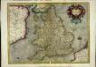
Anglia regnum
1 Karte : Kupferdruck ; 34 x 44 cm Mercator; Hondius Henricus Hondius
Anglia regnum
1 Karte : Kupferdruck ; 34 x 45 cm Mercator; Hondius Jodocus Hondius
England and Wales.
1 : 2860000 Higgins, W.M.
England.
1 : 1200000 Kiepert, Heinrich, 1818-1899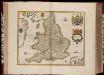
Anglia Regnum / [Joannes Janssonius]
1 : 1800000 Annotatie: Oorspr. verschenen in: Gerardi Mercatoris et I. Hondii Appendix Atlas ... - Amsterdam : bey Johan Jansson, 1636; Origineel is Blad 23 in atlas factice Janssonius, Joannes (jr.) (1588-1664) Amstelodami : apud Ioannem Ianssonium
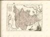
Anglia II. Nova Tabula [Karte], in: Geographia universalis vetus et nova complectens Claudii Ptolemaei Alexandrini enarrationis libros VIII, S. 305.
1 Karte aus Atlas Münster, Sebastian [und Ptolemaeus, Claudius]
Charte von England
1 Karte : Kupferdruck ; 47 x 53 cm Stieler im Verlage des geographischen Instituts
Anglia, Regnum si quod aliud in toto Oceano ditissimum et florentißimum. [Karte], in: Theatrum orbis terrarum, S. 83.
1 Karte aus Atlas Ortelius, Abraham Vrients, Jan Baptista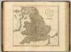
England.
1 : 1600000 Cary, John, ca. 1754-1835

Carte des Iles Britanniques.
1 : 2600000 Vivien de St Martin, L.

Geographische Carte von Gross-Britannien zum Gebrauch beim Studium der Geschichte
Historisch-genealogisch-geographischer Atlas von Le Sage Las Cases, Emmanuel Auguste Dieudonné Marius Joseph de Johann Velten, Kunsthändler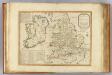
Invasions England, Ireland.
1 : 1770000 Robert Laurie & James Whittle
Anglia Regnum
1 : 1700000 Annotatie: Oorspr. verschenen in: Gerardi Mercatoris et I. Hondii Newer Atlas oder Grosses Weltbuch ... - Amsterdam : bey Johan Jansson, 1636 Amstelodami : apud Ioannem Ianssonium
Regnum Angliæ, sive pars australis Magnæ Britanniæ
1 Karte : Kupferdruck ; 47 x 58 cm Valck; Valck Gerard und Leonardus Valck
Anglia regnvm
1 Karte : Kupferdruck ; 37 x 48 cm s.n.
(La Grande-Bretagne)
1 : 12000000 Bruyset, Jean-Marie; Schneider, J. H.
Anglia Regnum [Karte], in: Novus Atlas, das ist, Weltbeschreibung, Bd. 3, S. 361.
1 Karte aus Atlas Blaeu, Joan Blaeu, Willem Janszoon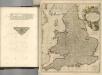

Novissima nec non perfectissima Regnorum Angliae, Scotiae et Hiberniae tabula, divisa in omnes suas partes et provincias
1 : 865000 Amstelodami : apud J. Covens et C. Mortier
Li regni d'Inghilterra e d'Irlanda
1 Karte : Kupferdruck ; 29 x 38 cm Zatta Antonio Zatta
Grossbritanien.
1 : 3900000 Haller von Hallerstein, Friedrich; Reichard, C. G.
![Angliae Regni Florentissimi Nova Descriptio [...] [Karte], in: Theatrum orbis terrarum, S. 36.](https://images-2.georeferencer.com/images/iiif/010512027665/full/,300/0/native.jpg)

