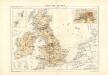
Maps of United Kingdom

Die Britischen Inseln 1066 bis 1485.
1 : 3100000 Spruner von Merz, Karl
MAGNÆ | BRITANNIÆ | et | HIBERNIÆ | TABVLA.
AMSTELODAMI, | Guiljelmus Blaeuw ecudit
Invasions England, Ireland.
1 : 1770000 Robert Laurie & James Whittle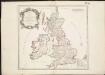
Britannicae Insulae in quibus Albion seu Britannia Major, et Ivernia seu Britannia Minor ...
1 : 2300000
Magnae Britanniae et Hiberniae Tabula [Karte] Orcades Insulae [Nebenkarte], in: Novus Atlas, das ist, Weltbeschreibung, Bd. 3, S. 358.
1 Karte aus Atlas Blaeu, Joan Blaeu, Willem Janszoon
Magnae Britanniae et Hiberniae Tabula. [Karte] Orcades Insulae [Nebenkarte], in: Gerardi Mercatoris et I. Hondii Newer Atlas, oder, Grosses Weltbuch, Bd. 1, S. 51.
1 Karte aus Atlas Mercator, Gerhard und Hondius, Jodocus Jansson, Jan
Nieuwe en perfeckte caerte van Engelandt, Schotlandt en Yerlandt
1 : 2470000 [Amsterdam] : nieuwelijck uyt gegeven bij Hugo Allardt, in de Calverstraet inde Werrelt Caert
Magnae Britanniae et Hiberniae Tabula [Karte] [Orcades Insulae] [Nebenkarte], in: Theatrum orbis terrarum, sive, Atlas novus, Bd. 4, S. 16.
1 Karte aus Atlas Blaeu, Joan Blaeu, Willem Janszoon
Nieuwe kaart van de eilanden van Groot Brittannien : behelzende de koningryken Engeland, Schotland en Ierland / volgens de laatste waarnemingen in het ligt gebragt ; C. Sepp del. et sculps. 1743
1 : 3500000 Annotatie: Oorspr. verschenen in: Nieuwe hand-atlas ... - Amsterdam : Isaak Tirion, 1744 Sepp, C. Te Amsterdam : by Isaak Tirion
Magnae Britanniae et Hiberniae Tabula [Karte] [Orcades Insulae] [Nebenkarte], in: Theatrum orbis terrarum, sive, Atlas novus, Bd. 4, S. 16.
1 Karte aus Atlas Blaeu, Joan Blaeu, Willem Janszoon
Magnae Britanniae et Hiberniae nova descriptio
1 : 2500000 Amstelodami : apud Joannem Janssonium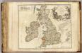
Iles Britaniques routes.
1 : 2075000 Robert de Vaugondy, Gilles, 1688-1766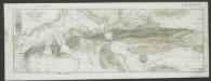
Magnae Britanniae et Hiberniae Tabula [Karte] Orcades Insulae [Nebenkarte], in: Le théâtre du monde, ou, Nouvel atlas contenant les chartes et descriptions de tous les païs de la terre, Bd. 4, S. 18.
1 Karte aus Atlas Blaeu, Willem Janszoon und Blaeu, Joan Blaeu, Willem Janszoon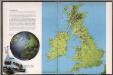
The British Isles
1 : 3000000 Debenham, Frank
Magnae Britanniae et Hiberniae Nova Descriptio [Karte] Orcades Insulae. [Nebenkarte], in: Novus atlas absolutissimus, Bd. 7, S. 29.
1 Karte aus Atlas Janssonius Offizin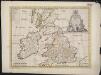
A new map of the Brittish Isles shewing their present genl. divisions, cities, and such other towns, or places, as answer to the towns of note in the time of the Romans
1 : 2851200
Allgemeine Postkarte von Gross Britanien und Ireland zur Uebersicht
Irsko Stenger, Johann im von Reillyschen Landkarten und Kunstwerke Verschleiss Komptoir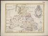
A new map of the Brittish Isles shewing their antient people, cities, and towns of note, in the time of the Romans
1 : 2846000
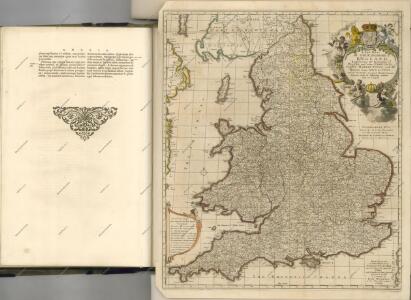
ANGLIAE SCOTIAE et HIBERNIAE Regna
Anglie
Die Britischen Inseln seit 1485.
1 : 3000000 Spruner von Merz, Karl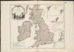
Les Isles Britanniques, qui comprennent les Royaumes d'Angleterre, d'Ecosse et d'Irlande
1 : 2000000
Die Britischen Inseln nach ihrer kirchlichen Eintheilung bis zur Reformation.
1 : 3000000 Spruner von Merz, Karl
Magnae Britanniae et Hiberniae Tabula
1 : 2300000
Britania et Hibernia
1 : 3000000 Irsko, ostrov Spruner, Karl von Justus Perthes
Grossbritannien und Ireland

British Isles.
1 : 2500000 Andree, Richard; Times (London, England)
Großbritannien und Irland
1 : 1000000 Irsko Velhagen & Klasing
Novissima nec non perfectissima Regnorum Angliae, Scotiae et Hiberniae tabula, divisa in omnes suas partes et provincias
1 : 865000 Amstelodami : apud J. Covens et C. Mortier