Maps of England

Anglia II. Nova Tabula [Karte], in: Geographia universalis vetus et nova complectens Claudii Ptolemaei Alexandrini enarrationis libros VIII, S. 305.
1 Karte aus Atlas Münster, Sebastian [und Ptolemaeus, Claudius]
England and Wales.
1 : 2860000 Higgins, W.M.
Carte du royaume d'Angleterre
1 Karte : Kupferdruck ; 75 x 51 cm Hérisson; Basset; Basset chez Basset rue St. Jacques no. 670
Spezialkarte von dem Königreiche England
1 Karte : Kupferdruck ; 20 x 27 cm Reilly F. J. J. von Reilly
delineation of the strata of England and Wales, with part of Scotland
Übersichtskarte Smith, William Cary
England.
1 : 1200000 Kiepert, Heinrich, 1818-1899
Angliae Regni Florentissimi Nova Descriptio [...] [Karte], in: Theatrum orbis terrarum, S. 36.
1 Karte aus Atlas Ortelius, Abraham
Angleterre, Galles.
1 : 1700000 Picquet, C.
England and Wales.
1 : 1450000 Johnson, A.J.
England and Wales.
1 : 1450000 Johnson, A.J.
England and Wales.
1 : 1450000 Johnson, A.J.
England, Wales.
1 : 4000000 Seaman, James V.
England, Wales.
1 : 2800000 Arrowsmith, Aaron; Lewis, Samuel
The post roads thorough England and Wales
1 Karte : Kupferdruck ; 55 x 47 cm Jefferys; Faden printed for Jefferys and Faden Corner of St Martin's Lane Charing Cross
The roads of England and Wales.
1 : 2400000 Moll, Herman, d. 1732
Charte von England
1 Karte : Kupferdruck ; 47 x 53 cm Stieler im Verlage des geographischen Instituts

A new map of England and Wales
1 Karte : Kupferdruck ; 51 x 50 cm Rocque sold by I. Rocque near Round Court in the Strand
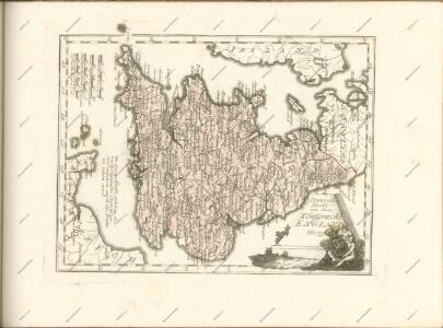
Britannia prout divisa suit temporibus Anglo-Saxonvm, præsertim durante illorum Heptarchia
1 Karte : Kupferdruck ; 40 x 30 cm, Bildgrösse 41 x 53 cm Blaeu Joan Blaeu
Composite: England, Wales.
1 : 675000 Rocque, John
An accurate map of England and Wales
1 Karte : Kupferdruck ; 58 x 49 cm Kitchin; Bowles; Bowles; Sayer; Tinney; Bowles printed for J. Tinney at the Golden Lion in Fleet Street T. Bowles in St. Pauls Church Yard John Bowles and son in Cornhil and Rob.t Sayer in Fleetstreet
The post roads thorough England and Wales
1 Karte : Kupferdruck ; 55 x 47 cm Jefferys; Dury printed for Andrew Dury in Dukes Court St Martin's Lane
47-48. Inghilterra, Galles.
1 : 1500000 Touring club italiano
Britannia Antiqua.
1 : 2800000 Horsley, John, 1675-1732
Le royaume d'Angleterre
1 Karte auf 2 Blättern : Kupferdruck ; 74 x 57 cm Sanson; Jaillot chez H. Iaillot
X. Charte für die allgemeine Geschichte vom Anfange des XXX-jährigen Krieges bis zur Selbstregierung Ludwig XIV : d.i. von 1618 bis 1661 n. Christus
Entworfen von F.W. Benicken A. Falger gr. Weimar : im Verlage des L. Industrie-Comptoirs
England and wales.
1 : 13000000 Colton, G.W.
Angleterre, Galles.
1 : 1700000 Brue, Adrien Hubert, 1786-1832
Regnum Angliæ, sive pars australis Magnæ Britanniæ
1 Karte : Kupferdruck ; 47 x 58 cm Valck; Valck Gerard und Leonardus Valck