Maps of Veneto
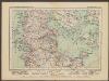
L'Etat De La Republique De Venise [...] Partie Orientale De La Republique De Venise [Karte] [Gebiet um Bergamo, Republique De Venise] [Nebenkarte] , in: Atlas nouveau, contenant toutes les parties du monde [...], Bd. 2, S. 158.
1 Karte aus Atlas Sanson, Nicolas Jaillot, Alexis Hubert und Mortier, Pieter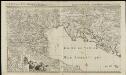
L'état de la République de Vénise
1 : 670000 par le Sr. Sanson A Amsterdam : chez Pierre Mortier & Cie
Severovýchodní Itálie a alpské země rakouské

[Österreich-Ungarn, Blatt 3]
Adolf Stieler's Handatlas über alle Theile der Erde und über das Weltgebäude Stieler, Adolf Justus Perthes
Karte des Oesterreichisch - ungarischen Reiches

Severovýchodní Italie a alpské země rakouské s Přímořím, Istrii [sic] a Chorvatskem
1 : 1000000 Alpy rakouské-oblast Emil Šolc

Tabula Itineraria Vienna Austriae Metropoli ad Orbis Urbem Romam
Mollova mapová sbírka Lidl, Johann Jakob Lidl, Johann Jacob
Etablissements der kaiserlichen königlichen Kriegsmarine
Jaderské moře-oblast
Übersichtskarte des südwestlichen Kriegsschauplatzes
1 : 750000 Evropa jihovýchodní k. u. k. Hof- und Universitätsbuchhandlung R. Lechner (W. Müller)
X, uit: General-Karte von Mittel-Europa in 12 Blättern, im Masse 1:1.200.000 / entworfen, bearb. und hrsg. von Josef Schlacher
1 : 1200000 Annotatie: Blad 6 ontbreekt; Annotatie geografische gegevens: 21 maatstokken op blad 9; Legenda op blad 9 Wien : K.K. Militär Geografisches Institut
Uibersichts-Carte der Staaten Toscana, Modena u. Parma mit ihrer neuen Gränzbestim[m]ung
Modena (Itálie)
Neue Karte von den franzoesischen Kriegs-Schauplatze in Ober und Mittel Italien, Tyrol, Friaul, Krain, Kaernthen, Steyermark etc
1 : 1720000 Furlandsko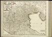
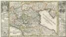
[30][30] Accuratissima Dominii Veneti in Italia,..., uit: Atlas sive Descriptio terrarum orbis
Annotatie: Gedigitaliseerde versie. Amsterdam. Heiloo : Picturae (vervaardiger), 2015. tiff-bestand. Gedigitaliseerd: 07-01-2015; Origineel: Universiteitsbibliotheek Vrije Universiteit (XL.05127.-) ; Netherlands; Titelpagina ontbreekt Wit, Frederik de Amsterdam : Frederick de Wit
Composite XI, XII, XVI, XVII: Karte Des Oesterreichischen Kaiserstaates.
1 : 576000 Scheda, Josef
Dominii Veneti in Italia in partes accurate divisi ac statuum ducum Parmae, Mutinae, Mantuae et Mirandolae novissima descriptio
1 : 810000 edita per Fredericum de Witt Amstelodami : [Frederick de Wit]
Die Niedere oder Oostliche Lombardia.
1 : 2900000 Mollova mapová sbírka Bodenehr, Gabriel Bodenehr, Gabriel
Italy. North Part.
1 : 2450000 Tanner, Henry S.
Italy North Part.
1 : 2450000 Tanner, Henry S.
Königreich Illyrien
1 : 1250000 Evropa jihovýchodní Mollo, Tranquillo Tranquillo Mollo
Generalkarte von Zentraleuropa
Tableau l'historie des Duches de Toscane, Parma, Modene, Lucques, et du Royme. Lombard-Venetien.
1 : 3100000 Duval, Henri
Die Staaten von Ober Italien
Itálie severní Stanich, Eugen Rothenburg, R. von Verlag der geographischen Anstalt des Bibliographischen Instituts
Ost-Alpenländer
Neuer Handatlas über alle Theile der Erde Kiepert, Heinrich Verlag von Dietrich Reimer
Florenz
1 : 1500000 Itálie severní K. u. k. Militärgeograph. Institute
Fo. 2, uit: Carta geologica d'Italia
1 : 1000000 Rome : R. Ufficio Geologico
Schlavoniae, Croatie, Carniae, Istriae, Bosniae, Finitimarumque Regionum Nova Descriptio [Karte], in: Theatrum orbis terrarum, S. 353.
1 Karte aus Atlas Ortelius, Abraham Vrients, Jan Baptista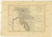
Königreich Illyrien nach der neuesten Eintheilung
1 : 1250000 Balkánský poloostrov
![L'Etat De La Republique De Venise [...] Partie Orientale De La Republique De Venise [Karte] [Gebiet um Bergamo, Republique De Venise] [Nebenkarte] , in: Atlas nouveau, contenant toutes les parties du monde [...], Bd. 2, S. 158.](https://images-2.georeferencer.com/images/iiif/992961480677/full/,300/0/native.jpg)

