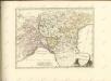
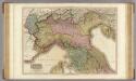
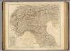
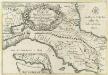
Maps of Toscana
Tableau l'historie des Duches de Toscane, Parma, Modene, Lucques, et du Royme. Lombard-Venetien.
1 : 3100000 Duval, Henri
Uibersichts-Carte der Staaten Toscana, Modena u. Parma mit ihrer neuen Gränzbestim[m]ung
Modena (Itálie)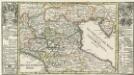
Die Niedere oder Oostliche Lombardia.
1 : 2900000 Mollova mapová sbírka Bodenehr, Gabriel Bodenehr, Gabriel
Die Staaten von Ober Italien
Itálie severní Stanich, Eugen Rothenburg, R. von Verlag der geographischen Anstalt des Bibliographischen Instituts
Die Staaten von Oberitalien

Italy. North Part.
1 : 2450000 Tanner, Henry S.
Italy North Part.
1 : 2450000 Tanner, Henry S.
76-77. Italy, North. The World Atlas.
1 : 1250000 USSR (Union of Soviet Socialist Republics).
Italy. North Part.
1 : 2500000 Mitchell, Samuel Augustus
Composite XI, XII, XVI, XVII: Karte Des Oesterreichischen Kaiserstaates.
1 : 576000 Scheda, Josef
Nördliches Jtalien
Stieler's Hand-Atlas Stieler, Adolf bei Justus Perthes
Italien 1.
1 : 1800000 Flemming, Carl
Northern Italy.
1 : 1090000 Pinkerton, John, 1758-1826
Italy middle, upper.
1 : 1100000 Robert Laurie & James Whittle
Italien. Nördliche Hälfte
N. Italy, Alps, Apennines.
1 : 1250000 Arrowsmith, John
Delineatio Regni Italici seu potius reliquiarum Regni Longobardici, quae hodie Longobardia seu Italis Lombardia dicuntur, finibus Franciae, Helvetiae, Germaniae, Dom. Veneti et St. Ecclesiae accurate distinctis
1 : 4600000 Mollova mapová sbírka Franz, Johann Michael Homann, Johann Baptista - dědici
Le royaume de France, 6
1 Blatt : 48 x 46 cm Jaillot
Italy, North Part.
1 : 2500000 Tanner, Henry S.
Florenz
1 : 1500000 Itálie severní K. u. k. Militärgeograph. Institute
Northern Italy.
1 : 1270000 Mitchell, Samuel Augustus
Northern Italy.
1 : 1270000 Mitchell, Samuel Augustus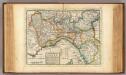
The upper part of Italy.
1 : 2700000 Moll, Herman, d. 1732
X, uit: General-Karte von Mittel-Europa in 12 Blättern, im Masse 1:1.200.000 / entworfen, bearb. und hrsg. von Josef Schlacher
1 : 1200000 Annotatie: Blad 6 ontbreekt; Annotatie geografische gegevens: 21 maatstokken op blad 9; Legenda op blad 9 Wien : K.K. Militär Geografisches Institut
Karte des Kriegschauplatzes in Italien
1 : 1800000 Itálie Dittmarsch, C. Trpog.-liter.-artist. Anstalt
Reyse-Cart von Italien :
1 : 3000000 Mollova mapová sbírka Bodenehr, Gabriel Bodenehr, Gabriel
Status Ecclesiae et Magni Ducatus Hetruriae