Maps of Slovenia


Fo. 2, uit: Carta geologica d'Italia
1 : 1000000 Rome : R. Ufficio Geologico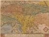
Schlavoniae, Croatiae, Carniae, Istriae, Bosniae, Finitimarumque Regionum Nova Descriptio [Karte], in: Theatrum orbis terrarum, S. 97.
1 Karte aus Atlas Ortelius, Abraham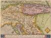
Schlavoniae, Croatie, Carniae, Istriae, Bosniae, Finitimarumque Regionum Nova Descriptio [Karte], in: Theatrum orbis terrarum, S. 258.
1 Karte aus Atlas Ortelius, Abraham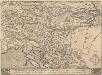
Schlavoniae, Croatie, Carniae, Istriae, Bosniae, Finitimarumque Regionum Nova Descriptio [Karte], in: Theatrum orbis terrarum, S. 353.
1 Karte aus Atlas Ortelius, Abraham Vrients, Jan Baptista
Pannoniae et Illyrici Veteris Tabvla
1 : 2200000 Mollova mapová sbírka Ortelius, Abraham Ortelius, Abraham
Illyricum. [Karte], in: Theatrum orbis terrarum, S. 350.
1 Karte aus Atlas Ortelius, Abraham Vrients, Jan Baptista
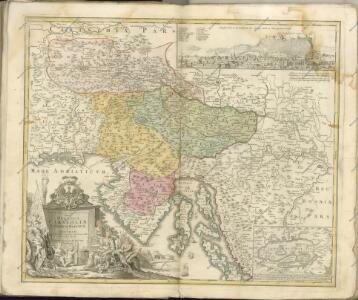
Sclavonia oder Windisch Marck, Bossen, Crabaten, etc. ; Sclauonia oder Windisch Marck, Bossen, Crabaten, ec.
1 : 330000 Krain, Steiermark Münster, Sebastian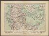
L'Etat De La Republique De Venise [...] Partie Orientale De La Republique De Venise [Karte] [Gebiet um Bergamo, Republique De Venise] [Nebenkarte] , in: Atlas nouveau, contenant toutes les parties du monde [...], Bd. 2, S. 158.
1 Karte aus Atlas Sanson, Nicolas Jaillot, Alexis Hubert und Mortier, Pieter
Schlavoniae, Croatiae, Carniae, Istriae, Bosniae, Finitimarumque Regionum Nova Descriptio
Südosteuropa Hirschvogel, Augustin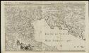
L'état de la République de Vénise
1 : 670000 par le Sr. Sanson A Amsterdam : chez Pierre Mortier & Cie
Carte internationale du monde au 1,000,000 E
1 : 1000000 Terst (Itálie) Istituto geografico militare
Carta d'Italia alla scala di 1 a 1 000 000
1 : 1000000 Nordost-Blatt Istituto Geografico Militare (Firenze) Istituto Geografico Militare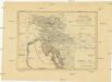
Königreich Illyrien nach der neuesten Eintheilung
1 : 1250000 Balkánský poloostrov
Königreich Illyrien nach der neuesten Eintheilung
1 : 1250000 Balkánský poloostrov
Illyricum. [Karte], in: Theatrum orbis terrarum, S. 255.
1 Karte aus Atlas Ortelius, Abraham
Charte von Innerostreich od. den Herzogthumern Steyermark, Kaernten u. Krain, mit den Gebiethen v. Gorz u. Triest
1 : 650000 Chorvatsko Streit, Friedrich Wilhelm Liechtenstern, Joseph Marx von
Severovýchodní Itálie a alpské země rakouské

Karte von Inneroesterreich oder das Herzoghtum Steyermark, Kaernthen und Krain
1 : 1080000 Korutansko (Rakousko) T. Mollo
Königreich Illyrien
1 : 1250000 Evropa jihovýchodní Mollo, Tranquillo Tranquillo Mollo
Karnthen, Krain, Gorz-Gradisca, Istrien, Triest.
1 : 875000 Flemming, Carl
Illyricum. Ioan. Sambucus Ortelio Suo, S. Mitto hanc quòque tabellam qua neceßaria confinia Pannoniae declarantur, fluviorum & aliquot locorum situs Hirschvogelij recte mutavi, Angelini autem studio plurima adieci, et intervalla correxi, ut parum quis si cum Hirschvogelij haec coniungat desideravit, si qui errores sint, dies certiora docebit
1 : 1200000 Illyrien, Dalmatien Sambucus, Johannes; Hirschvogel, Augustin
Carinthiae dvcatvs, et Goritiae palatinatvs / Wolf. Lazio auctore
3 Karten auf einem Blatt : Kupferdruck ; 33 x 49 cm Coppo, Pietro [Verlag nicht ermittelbar]
Carte del regno d'Illiria e del ducato Stiria
1 : 860000 Ilýrie Raffelsperger, Franz nel magazeno delle carte tipografiate
Karte der Kroländer Steyermark, Kärnthen, Krain und Istrien
1 : 1530000 Istrijský poloostrov (Slovinsko a Chorvatsko) Marco Berra
Königreich Illyrien
1 : 1233000 Ilýrie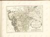

Das Königreich Illyrien und das Herzogthum Steyermark
1 : 700000 Ilýrie Weiland, Karl Ferdinand im Verlage des geographischen Instituts
Oesterr. Kronlander.
1 : 700000 Weiland, C. F. (Carl Ferdinand), d. 1847