Maps of Appennini

Generalkarte von Zentraleuropa

Zu den Ereignissen in Neapel und Spanisch-Tascana und zur Occupation des Kirchenstaates
Neapol (Itálie : oblast) K.k. Generalstabes
Etablissements der kaiserlichen königlichen Kriegsmarine
Jaderské moře-oblast
Karte des Oesterreichisch - ungarischen Reiches

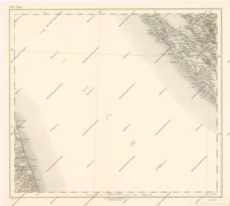
[Österreich-Ungarn, Blatt 3]
Adolf Stieler's Handatlas über alle Theile der Erde und über das Weltgebäude Stieler, Adolf Justus Perthes
Etat de l'eglise et duché de Toscane
1 : 1740000 Toskánsko (Itálie) Bonne, Rigobert André
Rajon dějstvīj russkago flota v vojnu s Francīej 1806-1807 gg. v Adrīatikě
Südeuropa Adria Seeschlacht
X, uit: General-Karte von Mittel-Europa in 12 Blättern, im Masse 1:1.200.000 / entworfen, bearb. und hrsg. von Josef Schlacher
1 : 1200000 Annotatie: Blad 6 ontbreekt; Annotatie geografische gegevens: 21 maatstokken op blad 9; Legenda op blad 9 Wien : K.K. Militär Geografisches Institut
Statvs ecclesiastici nec noc magni dvcatvs Toscaniae nova tabvla geographica
1 : 2780000 Papežský stát Mayer, Tobias curantibus Homannianis Heredibus
Statvs ecclesiastici nec noc magni dvcatvs Toscaniae nova tabvla geographica
1 : 2780000 Toskánsko (Itálie) Mayer, Tobias curantibus Homannianis Heredibus
Carta novissima della Dalmazia, Albania, Croazia, Bosnia
1 : 760000 Albánie Capellaris, Giovanni Antonio nel contojo delle arti e dell'industria
Tabula Itineraria Vienna Austriae Metropoli ad Orbis Urbem Romam
Mollova mapová sbírka Lidl, Johann Jakob Lidl, Johann Jacob
[Italien, Blatt 2]
Adolf Stieler's Handatlas über alle Theile der Erde und über das Weltgebäude Stieler, Adolf Justus Perthes
Estats de L'Eglise et de Toscane. [Karte], in: Atlas nouveau, contenant toutes les parties du monde [...], Bd. 2, S. 132.
1 Karte aus Atlas Sanson, Nicolas Jaillot, Alexis Hubert und Mortier, Pieter
Oesterreichisch-Ungarische Monarchie
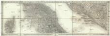
[Mittlere Italien]
1 : 576000 Itálie střední
Bassins du Tibre, de l'Arno, et du Garigliano : (Italie centrale)
1 : 2120000 Vuillemin, Alexandre Aimé 1812-1880 Paris : Delalain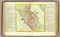
Etat de l'Eglise.
1 : 1500000 Clouet, J. B. L. (Jean-Baptiste Louis), b. 1730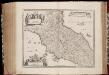
Stato della Chiesa con la Toscana
1 : 1035000 Annotatie: Met opdracht van Henricus Hondius; Origineel is Blad 162 in atlas factice; Annotatie geografische gegevens: Schaalstokken op de kaart: 60 Milliaria Italica communia (=10 cm), en: 12 Milliaria Germanica communia (=8,6 cm) Amstelodami : Sumptibus Ioannis Ianssonii
Stato Della Chiesa. Dominium Ecclesiasticum In Italia. [Karte], in: Gerardi Mercatoris et I. Hondii Newer Atlas, oder, Grosses Weltbuch, Bd. 2, S. 299.
1 Karte aus Atlas Mercator, Gerhard und Hondius, Jodocus Jansson, Jan
Stato Della Chiesa Con La Toscana [Karte], in: Novus atlas absolutissimus, Bd. 5, S. 142.
1 Karte aus Atlas Janssonius Offizin
Composite XI, XII, XVI, XVII: Karte Des Oesterreichischen Kaiserstaates.
1 : 576000 Scheda, Josef
Stato Della Chiesa, Con La Toscana. [Karte], in: Le théâtre du monde, ou, Nouvel atlas contenant les chartes et descriptions de tous les païs de la terre, Bd. 3, S. 165.
1 Karte aus Atlas Blaeu, Willem Janszoon und Blaeu, Joan Blaeu, Willem Janszoon
Stato Della Chiesa, Con La Toscana. [Karte], in: Novus Atlas, das ist, Weltbeschreibung, Bd. 3, S. 157.
1 Karte aus Atlas Blaeu, Joan Blaeu, Willem Janszoon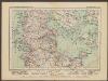
L'Etat De La Republique De Venise [...] Partie Orientale De La Republique De Venise [Karte] [Gebiet um Bergamo, Republique De Venise] [Nebenkarte] , in: Atlas nouveau, contenant toutes les parties du monde [...], Bd. 2, S. 158.
1 Karte aus Atlas Sanson, Nicolas Jaillot, Alexis Hubert und Mortier, Pieter
Stato Della Chiesa, Con La Toscana. [Karte], in: Theatrum orbis terrarum, sive, Atlas novus, Bd. 3, S. 137.
1 Karte aus Atlas Blaeu, Joan Blaeu, Willem Janszoon
STATO DELLA | CHIESA | CON LA TOSCANA
Guiljelmus Blaeu | excudit
Florenz
1 : 1500000 Itálie severní K. u. k. Militärgeograph. Institute
Dalmatia et regiones adjacentes, Croatia, Bosnia, Slavonia, Servia, Albania, accurate descriptae
1 : 1260000 Albánie Monath, Peter Konrad Petr Conr. Monath
Kirchenstaat
1 : 1100000 Itálie střední Biller, Bernhardt bey Tranquillo Mollo