Maps of Croatia

Key Sheet: Karte Des Oesterreichischen Kaiserstaates.
1 : 576000 Scheda, Josef
Severovýchodní Itálie a alpské země rakouské

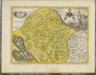
Schlavoniae, Croatiae, Carniae, Istriae, Bosniae, Finitimarumque Regionum Nova Descriptio
Südosteuropa Hirschvogel, Augustin
Schlavoniae, Croatie, Carniae, Istriae, Bosniae, Finitimarumque Regionum Nova Descriptio [Karte], in: Theatrum orbis terrarum, S. 258.
1 Karte aus Atlas Ortelius, Abraham
[Österreich-Ungarn, Blatt 3]
Adolf Stieler's Handatlas über alle Theile der Erde und über das Weltgebäude Stieler, Adolf Justus Perthes
Permanente Befestigungen
Győr (Maďarsko) K.k. Generalstabes
L'Etat De La Republique De Venise [...] Partie Orientale De La Republique De Venise [Karte] [Gebiet um Bergamo, Republique De Venise] [Nebenkarte] , in: Atlas nouveau, contenant toutes les parties du monde [...], Bd. 2, S. 158.
1 Karte aus Atlas Sanson, Nicolas Jaillot, Alexis Hubert und Mortier, Pieter
Fo. 2, uit: Carta geologica d'Italia
1 : 1000000 Rome : R. Ufficio Geologico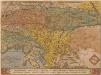
Schlavoniae, Croatiae, Carniae, Istriae, Bosniae, Finitimarumque Regionum Nova Descriptio [Karte], in: Theatrum orbis terrarum, S. 97.
1 Karte aus Atlas Ortelius, Abraham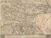
Schlavoniae, Croatie, Carniae, Istriae, Bosniae, Finitimarumque Regionum Nova Descriptio [Karte], in: Theatrum orbis terrarum, S. 353.
1 Karte aus Atlas Ortelius, Abraham Vrients, Jan Baptista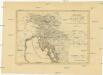
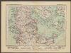
Königreich Illyrien nach der neuesten Eintheilung
1 : 1250000 Balkánský poloostrov
Königreich Illyrien nach der neuesten Eintheilung
1 : 1250000 Balkánský poloostrov
Severovýchodní Italie a alpské země rakouské s Přímořím, Istrii [sic] a Chorvatskem
1 : 1000000 Alpy rakouské-oblast Emil Šolc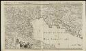
L'état de la République de Vénise
1 : 670000 par le Sr. Sanson A Amsterdam : chez Pierre Mortier & Cie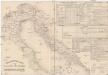
Etablissements der kaiserlichen königlichen Kriegsmarine
Jaderské moře-oblast
L'Empire d'Autriche
Nouvel atlas physique politique et historique de l'Empire ottoman et des états limitrophes en Europe, en Asie et en Afrique, en quarante feuilles Hellert, J.J. Bellizard, Dufour et Cie
Übersichtskarte des südwestlichen Kriegsschauplatzes
1 : 750000 Evropa jihovýchodní k. u. k. Hof- und Universitätsbuchhandlung R. Lechner (W. Müller)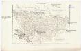
Charte von Bosnien und Servien
1 : 1767000 Bosna a Hercegovina Herz, W. Gleditsch
Regni Norici et Pannoniae Superioris Veteres Populi et Inquilini
1 : 2850000 Mollova mapová sbírka Clüver, Philipp Fuhrmann, Mathias
Neue Karte von den franzoesischen Kriegs-Schauplatze in Ober und Mittel Italien, Tyrol, Friaul, Krain, Kaernthen, Steyermark etc
1 : 1720000 Furlandsko
Tabula Itineraria Vienna Austriae Metropoli ad Orbis Urbem Romam
Mollova mapová sbírka Lidl, Johann Jakob Lidl, Johann Jacob
Illyricum. [Karte], in: Theatrum orbis terrarum, S. 255.
1 Karte aus Atlas Ortelius, Abraham
Königreich Illyrien
1 : 1250000 Evropa jihovýchodní Mollo, Tranquillo Tranquillo Mollo
Schlavoniae, Croatiae, Carniae, Istriae, Bosniae, finitimarvmqve regionvm nova descriptio / avctore
1 : 650000 1 Karte : Kupferdruck ; 31 x 46 cm Hirschvogel, Augustin [Verlag nicht ermittelbar]
Illyricum. [Karte], in: Theatrum orbis terrarum, S. 350.
1 Karte aus Atlas Ortelius, Abraham Vrients, Jan Baptista
Illyricum. Ioan. Sambucus Ortelio Suo, S. Mitto hanc quòque tabellam qua neceßaria confinia Pannoniae declarantur, fluviorum & aliquot locorum situs Hirschvogelij recte mutavi, Angelini autem studio plurima adieci, et intervalla correxi, ut parum quis si cum Hirschvogelij haec coniungat desideravit, si qui errores sint, dies certiora docebit
1 : 1200000 Illyrien, Dalmatien Sambucus, Johannes; Hirschvogel, Augustin
Königreich Illyrien
1 : 1233000 Ilýrie