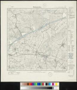
Maps of Hanerau-Hademarschen

Meßtischblatt 492 : Hademarschen, 1934
1 : 250000 Hademarschen. - Aufn. 1878, einz. Nachtr. 1925. - 1:25000. - [Berlin]: Reichsamt für Landesaufnahme, 1934. - 1 Kt.
Meßtischblatt 492 : Hademarschen, 1880
1 : 250000 Hademarschen. - Aufn. 1878. - 1:25000. - [Berlin]: Reichsamt für Landesaufnahme, 1880. - 1 Kt.
81. Hademarschen. (Germany)
1 : 100000 Reichsamt fur Landesaufnahme
Composite: 81. Hademarschen. (Germany)
1 : 100000 Reichsamt fur Landesaufnahme
DITHMARSIÆ | PARS AVSTRALIS.
Authore Iohannes Mejer, Husum Reg.e Maj.is | Mathematicus Matthias und Nicolaus Peters Goldts. gebr. Hus. sculps. [Amsterdam : Joan Blaeu]
DITHMARSIÆ | PARS SEPTENTRIONALIS [...]
author Iohannes Mejer Husum. | Regæ. Majis. Mathematicus Matthis Pet. v Clauß Peterss Goldtschmide unt gb. Hus. Cimbr. sculp. [Amsterdam : Joan Blaeu]
[left] DITHMARSIÆ | TABVLA; [right] DITHMARSIÆ | TABVLA
Auctore Joh: Meyer Husumensi | Anno 1559 Matthias & Nicolaus Peters | Goldtschmide gebr. Hus. sculps. [Amsterdam : Joan Blaeu]
23. Kiel, uit: Topographische Uebersichtskarte des Deutschen Reiches / herausgegeben v. d. Kartogr. Abt. d. Königl. Preuß. Landesaufnahme
1 : 200000 titelvariant: Topogr. Übersichtskarte des Deutschen Reiches; Annotatie: Titel boven bladen ook: Topogr. Übersichtskarte des Deutschen Reiches; Annotatie geografische gegevens: Op elk blad twee maatstokken: 10 Kilometer = 5,5 cm; 1 geogr. Meile = 3,6 cm; Legenda onder op elk blad Königlich Preußische Landesaufnahme. Kartographische Abtheilung [S.l : Königlich Preußische Landesaufnahme, Kartographische Abtheilung]
RENDSBVRGVM, | CHILONVM et BORDESHOLMA, | sive | HOLSATIA PROPRIA.
Christian Lorensen | Rodtgiesser Husum | sculpsit [Amsterdam : Joan Blaeu]
Nobilis Fluvius Albis maximâ curâ, ex variis, famosisque Autoribus collectus, et in lucem editus. [Karte, Teil 2], in: Gerardi Mercatoris et I. Hondii Newer Atlas, oder, Grosses Weltbuch, Bd. 1, S. 277.
1 Karte aus Atlas Mercator, Gerhard und Hondius, Jodocus Jansson, Jan
Schleswig-Holstein
1 : 50000 Šlesvicko-Holštýnsko (Německo) Reichs-Marine-Amt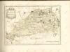

Nobilis Fluvius Albis maximâ curâ, ex variis famosisque Autoribus collectus, et in lucem editus. [Karte, Teil 2], in: Novus atlas absolutissimus, Bd. 2, S. 33.
1 Karte aus Atlas Janssonius Offizin
Kiel 21, uit: Special-Karte von Mittel-Europa / nach amtlichen Quellen bearbeitet von W. Liebenow
1 : 300000 titelvariant: W. Liebenow's Mittel-Europa; Annotatie: Titel boven de bladen: W. Liebenow's Mittel-Europa Johannes Wilhelm Liebenow 1822-1897 Frankfurt a. M. : Ludwig Ravenstein
Kiel 21, uit: [W. Liebenow's Special-Karte von Mittel-Europa]
1 : 300000 titelvariant: W. Liebenow's Mittel-Europa; Annotatie: Titel boven de bladen: W. Liebenow's Mittel-Europa Johannes Wilhelm Liebenow 1822-1897 Hannover : Hermann Oppermann
Dithmarsia Rendesburgum Kiel et Bordesholm in Occidentali parte Holsatiae
1 : 210000 Mollova mapová sbírka Schenk, Pieter Schenk, Peter I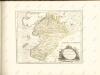

Dithmarsia, Rendesburgum, Kiel et Bordesholm, in Occidentali parte Holsatiae. [Karte], in: Novus atlas absolutissimus, Bd. 1, S. 146.
1 Karte aus Atlas Janssonius Offizin

[Herzogthum Holstein und Lauenburg, Fürstenthum Lübeck, Fr. Städte Hamburg und Lübeck nebst Amt Bergedorf]
Grosser Hand-Atlas über alle Theile der Erde in 170 Karten Meyer, J. Verlag des Bibliographischen Instituts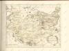

Holstein, Lauenburg, Lubeck, Hamburg.
1 : 440000 Meyer, Joseph, 1796-1856
Holstein, Lauenburg, Hamburg, Lubeck.
1 : 435000 Flemming, Carl
Tabvla Generalis Holsatiae complectens Holsatiae Dithmarsiae Stormariae et Vagriae Dvcatvs
1 : 310000 Mollova mapová sbírka Homann, Johann Baptist Homann, Johann Baptista
Tabvla Generalis Holsatiae complectens Holsatiae Dithmarsiae Stormariae et Vagriae Dvcatvs
1 : 310000 Mollova mapová sbírka Homann, Johann Baptist Homann, Johann Baptista

Holsatiae Tabula Generalis in qua sunt Ducatus Holsatiae Ditmarsiae Stormariae et Wagriae
1 : 310000 Mollova mapová sbírka Schenk, Pieter Schenk, Peter I
Holsatiae Dithmarsiae Stormariae et Vagriae Dvcatvs
1 : 480000 Mollova mapová sbírka Weigel, Christoph Kauffer, Michael Weigel, Christoph I.
Herzogthum Holstein im Nieder Sächsischen Creisse mit seinen abgetheilten Provintzien
Mollova mapová sbírka Weigel, Christoph Weigel, Christoph I.