Maps of Dithmarschen

[left] DITHMARSIÆ | TABVLA; [right] DITHMARSIÆ | TABVLA
Auctore Joh: Meyer Husumensi | Anno 1559 Matthias & Nicolaus Peters | Goldtschmide gebr. Hus. sculps. [Amsterdam : Joan Blaeu]
Dithmarsiae Tabvla
1 : 150000 Mollova mapová sbírka Mejer, Johannes Peters, Matthias Blaeu, Joan I.
Thietmarsiae, Holsaticae Regionis Partis Typus. [Karte], in: Theatrum orbis terrarum, S. 58.
1 Karte aus Atlas Ortelius, Abraham
Thietmarsiae, Holsaticae Regionis Partis Typus. [Karte] , in: Theatrum orbis terrarum, S. 212.
1 Karte aus Atlas Ortelius, Abraham Vrients, Jan Baptista
Thietmarsiae, Hosaticae Regionis Partis Typvs
1 : 200000 Mollova mapová sbírka Boekel, Peter
Dithmarsiae Tabvla
1 : 150000 Mollova mapová sbírka Mejer, Johannes Peters, Matthias Blaeu, Joan I.
Thietmarsiae, Holsaticae regionis partis typvs
1 Karte : Kupferdruck ; 30 x 20 cm Boeckel; Ortelius s.n.
Thietmarsiae, Holsaticae regionis partis typvs
1 Karte : Kupferdruck ; 31 x 20 cm Boeckel; Ortelius s.n.
DITHMARSIÆ | PARS SEPTENTRIONALIS [...]
author Iohannes Mejer Husum. | Regæ. Majis. Mathematicus Matthis Pet. v Clauß Peterss Goldtschmide unt gb. Hus. Cimbr. sculp. [Amsterdam : Joan Blaeu]
DITHMARSIÆ | PARS AVSTRALIS.
Authore Iohannes Mejer, Husum Reg.e Maj.is | Mathematicus Matthias und Nicolaus Peters Goldts. gebr. Hus. sculps. [Amsterdam : Joan Blaeu]
Composite: 80. Heide. (Germany)
1 : 100000 Reichsamt fur Landesaufnahme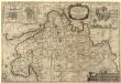
Dithmarsiae Pars Septentrionalis
1 : 75000 Mollova mapová sbírka Mejer, Johannes Peters, Matthias Blaeu, Joan I.
Composite: 111. Otterndorf. (Germany)
1 : 100000 Reichsamt fur Landesaufnahme
80. Heide. (Germany)
1 : 100000 Reichsamt fur Landesaufnahme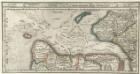
Gluckstatt mitt dero Gegend Westwerth und von daar die Elbe vollend hinnab zufahren bis in die Westsee, sampt dem Hamburgischen Ampt Ritzbuttel.
1 : 310000 Mollova mapová sbírka Bodenehr, Gabriel Bodenehr, Gabriel
Composite: 81. Hademarschen. (Germany)
1 : 100000 Reichsamt fur Landesaufnahme
Composite: 56. Husum. (Germany)
1 : 100000 Reichsamt fur Landesaufnahme
56. Husum. (Germany)
1 : 100000 Reichsamt fur Landesaufnahme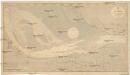
Nordsee
1 : 25000 Cuxhaven (Německo) Reichs-Marine-Amt
TERRITORIA | EIJDERSTEDE | Everschop | et | Uthholm.
Matthias und Nicolaus Pet. Goldtschmide gebr. | Husum. sculps. [Amsterdam : Joan Blaeu]
Meßtischblatt 653 : Wilster, 1888
1 : 250000 Wilster. - Aufn. 1878, hrsg. 1880, bericht. 1888. - 1:25000. - [Berlin]: Reichsamt für Landesaufnahme, 1888. - 1 Kt.
Meßtischblatt 2021 : Burg i. Dithm., 1931
1 : 250000 Burg i. Dithm. - Aufn. 1878, hrsg. 1880, bericht. 1931. - 1:25000. - [Berlin]: Reichsamt für Landesaufnahme, 1931. - 1 Kt.
Meßtischblatt 651 : Marne, 1906
1 : 250000 Marne. - Aufn. 1878, hrsg. 1880, einz. Nachtr. 1906. - 1:25000. - [Berlin]: Reichsamt für Landesaufnahme, 1906. - 1 Kt.
Meßtischblatt 650 : Kaiser-Wilhelm-Koog, 1931
1 : 250000 Kaiser-Wilhelm-Koog. - Aufn. 1878, hrsg. 1880, bericht. 1931. - 1:25000. - [Berlin]: Reichsamt für Landesaufnahme, 1931. - 1 Kt.
Meßtischblatt 569 : Schenefeld, 1904
1 : 250000 Schenefeld. - Aufn. 1878, hrsg. 1880, einz. Nachtr. 1904. - 1:25000. - [Berlin]: Reichsamt für Landesaufnahme, 1904. - 1 Kt.
Meßtischblatt 568 : Süderhastedt, 1900
1 : 250000 Süderhastedt. - Aufn. 1878, hrsg. 1880, einz. Nachtr. 1900. - 1:25000. - [Berlin]: Reichsamt für Landesaufnahme, 1900. - 1 Kt.
Meßtischblatt 567 : Meldorf, 1880
1 : 250000 Meldorf. - Aufn. 1878. - 1:25000. - [Berlin]: Reichsamt für Landesaufnahme, 1880. - 1 Kt.
Meßtischblatt 566, neue Nr. 1919 : Übersichtskarte des Adolf-Hitler-Kooges, 1935
1 : 250000 Übersichtskarte des Adolf-Hitler-Kooges. - Hrsg. 1935. - 1:25000. - [Berlin]: Reichsamt für Landesaufnahme, 1935. - 1 Kt.
Meßtischblatt 492 : Hademarschen, 1934
1 : 250000 Hademarschen. - Aufn. 1878, einz. Nachtr. 1925. - 1:25000. - [Berlin]: Reichsamt für Landesaufnahme, 1934. - 1 Kt.
![[left] DITHMARSIÆ | TABVLA; [right] DITHMARSIÆ | TABVLA](https://images-2.georeferencer.com/images/iiif/257638668614/full/,300/0/native.jpg)

