Maps of Eider
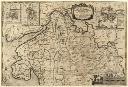
Dithmarsiae Pars Septentrionalis
1 : 75000 Mollova mapová sbírka Mejer, Johannes Peters, Matthias Blaeu, Joan I.
Composite: 56. Husum. (Germany)
1 : 100000 Reichsamt fur Landesaufnahme
Meßtischblatt 421 : Tellingstedt, 1928
1 : 250000 Tellingstedt. - Hrsg. 1880, bericht. 1928. - 1:25000. - [Berlin]: Reichsamt für Landesaufnahme, 1928. - 1 Kt.
Meßtischblatt 420 : Weddingstedt, 1919
1 : 250000 Weddingstedt. - Aufn. 1878, kleine Nachtr. 1919. - 1:25000. - [Berlin]: Reichsamt für Landesaufnahme, 1919. - 1 Kt.
Meßtischblatt 419 : Wesselburen, 1928
1 : 250000 Wesselburen. - Hrsg. 1880, bericht. 1928. - 1:25000. - [Berlin]: Reichsamt für Landesaufnahme, 1928. - 1 Kt.
Meßtischblatt 356 : Süderstapel, 1910
1 : 250000 Süderstapel. - Aufn. 1878, hrsg. 1880, einz. Nachtr. 1910. - 1:25000. - [Berlin]: Reichsamt für Landesaufnahme, 1910. - 1 Kt.
Meßtischblatt 355 : Friedrichstadt, 1895
1 : 250000 Friedrichstadt. - Aufn. 1878, hrsg. 1880, einz. Nachtr. 1895. - 1:25000. - [Berlin]: Reichsamt für Landesaufnahme, 1895. - 1 Kt.
Meßtischblatt 354 : Tönning, 1910
1 : 250000 Tönning. - Aufn. 1878, hrsg. 1880, einz. Nachtr. 1910. - 1:25000. - [Berlin]: Reichsamt für Landesaufnahme, 1910. - 1 Kt.
Meßtischblatt 491 : Nordhastedt, 1895
1 : 250000 Nordhastedt. - Aufn. 1878, hrsg. 1880, einz. Nachtr. 1895. - 1:25000. - [Berlin]: Reichsamt für Landesaufnahme, 1895. - 1 Kt.
Meßtischblatt 490 : Heide, 1896
1 : 250000 Heide. - Aufn. 1878, hrsg. 1880. - 1:25000. - [Berlin]: Reichsamt für Landesaufnahme, 1896. - 1 Kt.
Meßtischblatt 489 : Büsum, 1880
1 : 250000 Büsum. - Aufn. 1878. - 1:25000. - [Berlin]: Reichsamt für Landesaufnahme, 1880. - 1 Kt.
Tönningen.
Mollova mapová sbírka Bodenehr, Gabriel Bodenehr, Gabriel
Meßtischblatt 422 : Dellstedt, 1914
1 : 250000 Dellstedt. - Aufn. 1877/78, hrsg. 1880, Aufldr. 1914. - 1:25000. - [Berlin]: Reichsamt für Landesaufnahme, 1914. - 1 Kt.
Meßtischblatt 357 : Meggerdorf, 1884
1 : 250000 Meggerdorf. - Aufn. 1877, hrsg. 1879, einz. Nachtr. 1884. - 1:25000. - [Berlin]: Reichsamt für Landesaufnahme, 1884. - 1 Kt.
Dithmarsiae Tabvla
1 : 150000 Mollova mapová sbírka Mejer, Johannes Peters, Matthias Blaeu, Joan I.
DITHMARSIÆ | PARS SEPTENTRIONALIS [...]
author Iohannes Mejer Husum. | Regæ. Majis. Mathematicus Matthis Pet. v Clauß Peterss Goldtschmide unt gb. Hus. Cimbr. sculp. [Amsterdam : Joan Blaeu]
Thietmarsiae, Holsaticae Regionis Partis Typus. [Karte], in: Theatrum orbis terrarum, S. 58.
1 Karte aus Atlas Ortelius, Abraham
Thietmarsiae, Holsaticae Regionis Partis Typus. [Karte] , in: Theatrum orbis terrarum, S. 212.
1 Karte aus Atlas Ortelius, Abraham Vrients, Jan Baptista
[left] DITHMARSIÆ | TABVLA; [right] DITHMARSIÆ | TABVLA
Auctore Joh: Meyer Husumensi | Anno 1559 Matthias & Nicolaus Peters | Goldtschmide gebr. Hus. sculps. [Amsterdam : Joan Blaeu]
Thietmarsiae, Holsaticae regionis partis typvs
1 Karte : Kupferdruck ; 30 x 20 cm Boeckel; Ortelius s.n.
Thietmarsiae, Holsaticae regionis partis typvs
1 Karte : Kupferdruck ; 31 x 20 cm Boeckel; Ortelius s.n.
Dithmarsiae Tabvla
1 : 150000 Mollova mapová sbírka Mejer, Johannes Peters, Matthias Blaeu, Joan I.
22. Husum, uit: Topographische Uebersichtskarte des Deutschen Reiches / herausgegeben v. d. Kartogr. Abt. d. Königl. Preuß. Landesaufnahme
1 : 200000 titelvariant: Topogr. Übersichtskarte des Deutschen Reiches; Annotatie: Titel boven bladen ook: Topogr. Übersichtskarte des Deutschen Reiches; Annotatie geografische gegevens: Op elk blad twee maatstokken: 10 Kilometer = 5,5 cm; 1 geogr. Meile = 3,6 cm; Legenda onder op elk blad Königlich Preußische Landesaufnahme. Kartographische Abtheilung [S.l : Königlich Preußische Landesaufnahme, Kartographische Abtheilung]
Thietmarsiae, Hosaticae Regionis Partis Typvs
1 : 200000 Mollova mapová sbírka Boekel, Peter
56. Husum. (Germany)
1 : 100000 Reichsamt fur Landesaufnahme
80. Heide. (Germany)
1 : 100000 Reichsamt fur Landesaufnahme
Composite: 80. Heide. (Germany)
1 : 100000 Reichsamt fur Landesaufnahme
Composite: 81. Hademarschen. (Germany)
1 : 100000 Reichsamt fur Landesaufnahme
TERRITORIA | EIJDERSTEDE | Everschop | et | Uthholm.
Matthias und Nicolaus Pet. Goldtschmide gebr. | Husum. sculps. [Amsterdam : Joan Blaeu]
Meßtischblatt 492 : Hademarschen, 1934
1 : 250000 Hademarschen. - Aufn. 1878, einz. Nachtr. 1925. - 1:25000. - [Berlin]: Reichsamt für Landesaufnahme, 1934. - 1 Kt.