Maps of Schenefeld

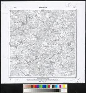
Meßtischblatt 569 : Schenefeld, 1904
1 : 250000 Schenefeld. - Aufn. 1878, hrsg. 1880, einz. Nachtr. 1904. - 1:25000. - [Berlin]: Reichsamt für Landesaufnahme, 1904. - 1 Kt.
81. Hademarschen. (Germany)
1 : 100000 Reichsamt fur Landesaufnahme
Composite: 81. Hademarschen. (Germany)
1 : 100000 Reichsamt fur Landesaufnahme
DITHMARSIÆ | PARS AVSTRALIS.
Authore Iohannes Mejer, Husum Reg.e Maj.is | Mathematicus Matthias und Nicolaus Peters Goldts. gebr. Hus. sculps. [Amsterdam : Joan Blaeu]
Composite: 111. Otterndorf. (Germany)
1 : 100000 Reichsamt fur Landesaufnahme
[left] DITHMARSIÆ | TABVLA; [right] DITHMARSIÆ | TABVLA
Auctore Joh: Meyer Husumensi | Anno 1559 Matthias & Nicolaus Peters | Goldtschmide gebr. Hus. sculps. [Amsterdam : Joan Blaeu]
23. Kiel, uit: Topographische Uebersichtskarte des Deutschen Reiches / herausgegeben v. d. Kartogr. Abt. d. Königl. Preuß. Landesaufnahme
1 : 200000 titelvariant: Topogr. Übersichtskarte des Deutschen Reiches; Annotatie: Titel boven bladen ook: Topogr. Übersichtskarte des Deutschen Reiches; Annotatie geografische gegevens: Op elk blad twee maatstokken: 10 Kilometer = 5,5 cm; 1 geogr. Meile = 3,6 cm; Legenda onder op elk blad Königlich Preußische Landesaufnahme. Kartographische Abtheilung [S.l : Königlich Preußische Landesaufnahme, Kartographische Abtheilung]
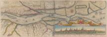
RENDSBVRGVM, | CHILONVM et BORDESHOLMA, | sive | HOLSATIA PROPRIA.
Christian Lorensen | Rodtgiesser Husum | sculpsit [Amsterdam : Joan Blaeu]
Nobilis Fluvius Albis maximâ curâ, ex variis, famosisque Autoribus collectus, et in lucem editus. [Karte, Teil 2], in: Gerardi Mercatoris et I. Hondii Newer Atlas, oder, Grosses Weltbuch, Bd. 1, S. 277.
1 Karte aus Atlas Mercator, Gerhard und Hondius, Jodocus Jansson, Jan
Schleswig-Holstein
1 : 50000 Šlesvicko-Holštýnsko (Německo) Reichs-Marine-Amt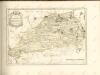
Nobilis Fluvius Albis maximâ curâ, ex variis famosisque Autoribus collectus, et in lucem editus. [Karte, Teil 2], in: Novus atlas absolutissimus, Bd. 2, S. 33.
1 Karte aus Atlas Janssonius Offizin
Tabula Geographica novissima Ducatus Stormariae, in Meridionali parte Holsatiae. [Karte], in: Novus atlas absolutissimus, Bd. 1, S. 152.
1 Karte aus Atlas Janssonius Offizin
Dithmarsia Rendesburgum Kiel et Bordesholm in Occidentali parte Holsatiae
1 : 210000 Mollova mapová sbírka Schenk, Pieter Schenk, Peter I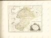

Dithmarsia, Rendesburgum, Kiel et Bordesholm, in Occidentali parte Holsatiae. [Karte], in: Novus atlas absolutissimus, Bd. 1, S. 146.
1 Karte aus Atlas Janssonius Offizin

[Herzogthum Holstein und Lauenburg, Fürstenthum Lübeck, Fr. Städte Hamburg und Lübeck nebst Amt Bergedorf]
Grosser Hand-Atlas über alle Theile der Erde in 170 Karten Meyer, J. Verlag des Bibliographischen Instituts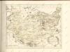

Holstein, Lauenburg, Lubeck, Hamburg.
1 : 440000 Meyer, Joseph, 1796-1856
Holstein, Lauenburg, Hamburg, Lubeck.
1 : 435000 Flemming, Carl
Tabvla Generalis Holsatiae complectens Holsatiae Dithmarsiae Stormariae et Vagriae Dvcatvs
1 : 310000 Mollova mapová sbírka Homann, Johann Baptist Homann, Johann Baptista
Tabvla Generalis Holsatiae complectens Holsatiae Dithmarsiae Stormariae et Vagriae Dvcatvs
1 : 310000 Mollova mapová sbírka Homann, Johann Baptist Homann, Johann Baptista

Holsatiae Tabula Generalis in qua sunt Ducatus Holsatiae Ditmarsiae Stormariae et Wagriae
1 : 310000 Mollova mapová sbírka Schenk, Pieter Schenk, Peter I
Holsatiae Dithmarsiae Stormariae et Vagriae Dvcatvs
1 : 480000 Mollova mapová sbírka Weigel, Christoph Kauffer, Michael Weigel, Christoph I.
Herzogthum Holstein im Nieder Sächsischen Creisse mit seinen abgetheilten Provintzien
Mollova mapová sbírka Weigel, Christoph Weigel, Christoph I.
Holsatia ducatus
1 Karte : Kupferdruck ; 33 x 46 cm Mercator; Hondius Henricus Hondius
Tabvla generalis Holsatiae complectens Holsatiae Dithmarsiae Stormariae et Vargiae dvcatvs
1 : 316000 Holštýnsko Homann, Johann Baptist a Ioh. Bapt. Homanno