Maps of Rendsburg-Eckernförde

23. Kiel, uit: Topographische Uebersichtskarte des Deutschen Reiches / herausgegeben v. d. Kartogr. Abt. d. Königl. Preuß. Landesaufnahme
1 : 200000 titelvariant: Topogr. Übersichtskarte des Deutschen Reiches; Annotatie: Titel boven bladen ook: Topogr. Übersichtskarte des Deutschen Reiches; Annotatie geografische gegevens: Op elk blad twee maatstokken: 10 Kilometer = 5,5 cm; 1 geogr. Meile = 3,6 cm; Legenda onder op elk blad Königlich Preußische Landesaufnahme. Kartographische Abtheilung [S.l : Königlich Preußische Landesaufnahme, Kartographische Abtheilung]
RENDSBVRGVM, | CHILONVM et BORDESHOLMA, | sive | HOLSATIA PROPRIA.
Christian Lorensen | Rodtgiesser Husum | sculpsit [Amsterdam : Joan Blaeu]
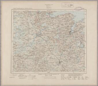
Composite: 57. Rendsburg. (Germany)
1 : 100000 Reichsamt fur Landesaufnahme
PRÆFECTVRÆ | GOTTORPIENSIS | PARS AVSTRALIS.
Matthias und Clauss Peters. | Goldtschmide und gbr. sculp. Husumens. [Amsterdam : Joan Blaeu]
58. Kiel. (Germany)
1 : 100000 Reichsamt fur Landesaufnahme
Composite: 81. Hademarschen. (Germany)
1 : 100000 Reichsamt fur Landesaufnahme
57. Rendsburg. (Germany)
1 : 100000 Reichsamt fur Landesaufnahme
82. Neumunster. (Germany)
1 : 100000 Reichsamt fur Landesaufnahme
Composite: 82. Neumunster. (Germany)
1 : 100000 Reichsamt fur Landesaufnahme
Composite: 58. Kiel. (Germany)
1 : 100000 Reichsamt fur Landesaufnahme
81. Hademarschen. (Germany)
1 : 100000 Reichsamt fur Landesaufnahme
SYLVA DANICA | vulgo | DÆNISCHEN WALDE.
[Amsterdam : Joan Blaeu]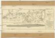
Plan des Holsteinschen Canals zwischen Rendsburg und dem Kieler Fiord nebst dessen Profil
1 : 125000 Kiel (Německo)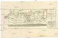
PLAN des Holsteinschen CANALS Zwischen Rendsburg und dem Kieler Fiord nebst dessen Profil
1 : 120000 Kiel (Německo)
Plan des Holsteinschen Canals zwischen Rendsburg und dem Kieler Fiord nebst dessen Profil
1 : 125000 Kiel (Německo)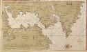
Afteekening van Kieler Fioerd en Christian Hafen
Germany Gerard van Keulen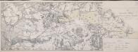
Die Dannewerks-Stellung
1 : 40000
Kiel und kieler Föhrde
1 : 50000 Kiel (Německo) F.A. Brockhaus' geogr.-artist. Anstalt
Kieler Hafen
1 : 55000 Kielský záliv (Německo) Bibliogr. Institut
Meßtischblatt 574 : Bornhöved, 1925
1 : 250000 Bornhöved. - Aufn. 1877, bericht. 1913, Nachtr. 1925. - 1:25000. - [Berlin]: Reichsamt für Landesaufnahme, 1925. - 1 Kt.
Meßtischblatt 573 : Gr. Kummerfeld, 1925
1 : 250000 Gr. Kummerfeld. - Aufn. 1877, Nachtr. 1925. - 1:25000. - [Berlin]: Reichsamt für Landesaufnahme, 1925. - 1 Kt.
Meßtischblatt 572 : Neumünster, 1925
1 : 250000 Neumünster. - Aufn. 1877, Nachtr. 1925. - 1:25000. - [Berlin]: Reichsamt für Landesaufnahme, 1925. - 1 Kt.
Meßtischblatt 572 : Hennstedt, 1895
1 : 250000 Hennstedt. - Aufn. 1878, hrsg. 1880, einz. Nachtr. 1895. - 1:25000. - [Berlin]: Reichsamt für Landesaufnahme, 1895. - 1 Kt.
Meßtischblatt 570 : Hohenwestedt, 1919
1 : 250000 Hohenwestedt. - Aufn. 1878, Nachtr. 1919. - 1:25000. - [Berlin]: Reichsamt für Landesaufnahme, 1919. - 1 Kt.
Meßtischblatt 569 : Schenefeld, 1904
1 : 250000 Schenefeld. - Aufn. 1878, hrsg. 1880, einz. Nachtr. 1904. - 1:25000. - [Berlin]: Reichsamt für Landesaufnahme, 1904. - 1 Kt.
Meßtischblatt 497 : Stolpe (i. Schleswig), 1896
1 : 250000 Stolpe (i. Schleswig). - Aufn. 1877, hrsg. 1879, einz. Nachtr. 1896. - 1:25000. - [Berlin]: Reichsamt für Landesaufnahme, 1896. - 1 Kt.
Meßtischblatt 496 : Brügge, 1932
1 : 250000 Brügge. - Hrsg. 1879, bericht. 1913. - 1:25000. - [Berlin]: Reichsamt für Landesaufnahme, 1932. - 1 Kt.
Meßtischblatt 495 : Nortorf, 1925
1 : 250000 Nortorf. - Aufn. 1877, bericht. 1913, Nachtr. 1925. - 1:25000. - [Berlin]: Reichsamt für Landesaufnahme, 1925. - 1 Kt.
Meßtischblatt 494 : Holtdorf, 1896
1 : 250000 Holtdorf. - Aufn. 1878, hrsg. 1880, einz. Nachtr. 1896. - 1:25000. - [Berlin]: Reichsamt für Landesaufnahme, 1896. - 1 Kt.