Maps of Mittelholstein

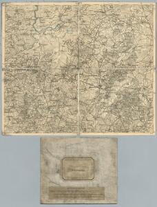
81. Hademarschen. (Germany)
1 : 100000 Reichsamt fur Landesaufnahme
Meßtischblatt 493 : Todenbüttel, 1902
1 : 250000 Todenbüttel. - Aufn. 1878, hrsg. 1880, einz. Nachtr. 1902. - 1:25000. - [Berlin]: Reichsamt für Landesaufnahme, 1902. - 1 Kt.
Meßtischblatt 492 : Hademarschen, 1934
1 : 250000 Hademarschen. - Aufn. 1878, einz. Nachtr. 1925. - 1:25000. - [Berlin]: Reichsamt für Landesaufnahme, 1934. - 1 Kt.
Meßtischblatt 492 : Hademarschen, 1880
1 : 250000 Hademarschen. - Aufn. 1878. - 1:25000. - [Berlin]: Reichsamt für Landesaufnahme, 1880. - 1 Kt.
Meßtischblatt 494 : Holtdorf, 1896
1 : 250000 Holtdorf. - Aufn. 1878, hrsg. 1880, einz. Nachtr. 1896. - 1:25000. - [Berlin]: Reichsamt für Landesaufnahme, 1896. - 1 Kt.
Meßtischblatt 570 : Hohenwestedt, 1919
1 : 250000 Hohenwestedt. - Aufn. 1878, Nachtr. 1919. - 1:25000. - [Berlin]: Reichsamt für Landesaufnahme, 1919. - 1 Kt.
Meßtischblatt 569 : Schenefeld, 1904
1 : 250000 Schenefeld. - Aufn. 1878, hrsg. 1880, einz. Nachtr. 1904. - 1:25000. - [Berlin]: Reichsamt für Landesaufnahme, 1904. - 1 Kt.
Meßtischblatt 572 : Hennstedt, 1895
1 : 250000 Hennstedt. - Aufn. 1878, hrsg. 1880, einz. Nachtr. 1895. - 1:25000. - [Berlin]: Reichsamt für Landesaufnahme, 1895. - 1 Kt.
Composite: 81. Hademarschen. (Germany)
1 : 100000 Reichsamt fur Landesaufnahme
Meßtischblatt 422 : Dellstedt, 1914
1 : 250000 Dellstedt. - Aufn. 1877/78, hrsg. 1880, Aufldr. 1914. - 1:25000. - [Berlin]: Reichsamt für Landesaufnahme, 1914. - 1 Kt.
Meßtischblatt 423 : Hamdorf (Kreis Rendsburg), 1910
1 : 250000 Hamdorf (Kreis Rendsburg). - Aufn. 1877/78, hrsg. 1880, einz. Nachtr. 1910. - 1:25000. - [Berlin]: Reichsamt für Landesaufnahme, 1910. - 1 Kt.
Meßtischblatt 424 : Bokelholm, 1896
1 : 250000 Bokelholm. - Aufn. 1877/78, hrsg. 1880, einz. Nachtr. 1896. - 1:25000. - [Berlin]: Reichsamt für Landesaufnahme, 1896. - 1 Kt.
23. Kiel, uit: Topographische Uebersichtskarte des Deutschen Reiches / herausgegeben v. d. Kartogr. Abt. d. Königl. Preuß. Landesaufnahme
1 : 200000 titelvariant: Topogr. Übersichtskarte des Deutschen Reiches; Annotatie: Titel boven bladen ook: Topogr. Übersichtskarte des Deutschen Reiches; Annotatie geografische gegevens: Op elk blad twee maatstokken: 10 Kilometer = 5,5 cm; 1 geogr. Meile = 3,6 cm; Legenda onder op elk blad Königlich Preußische Landesaufnahme. Kartographische Abtheilung [S.l : Königlich Preußische Landesaufnahme, Kartographische Abtheilung]
RENDSBVRGVM, | CHILONVM et BORDESHOLMA, | sive | HOLSATIA PROPRIA.
Christian Lorensen | Rodtgiesser Husum | sculpsit [Amsterdam : Joan Blaeu]
Schleswig-Holstein
1 : 50000 Šlesvicko-Holštýnsko (Německo) Reichs-Marine-Amt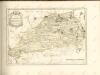

Dithmarsia Rendesburgum Kiel et Bordesholm in Occidentali parte Holsatiae
1 : 210000 Mollova mapová sbírka Schenk, Pieter Schenk, Peter I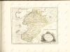

Dithmarsia, Rendesburgum, Kiel et Bordesholm, in Occidentali parte Holsatiae. [Karte], in: Novus atlas absolutissimus, Bd. 1, S. 146.
1 Karte aus Atlas Janssonius Offizin
Das oestliche Holstein

Kiel 21, uit: [W. Liebenow's Special-Karte von Mittel-Europa]
1 : 300000 titelvariant: W. Liebenow's Mittel-Europa; Annotatie: Titel boven de bladen: W. Liebenow's Mittel-Europa Johannes Wilhelm Liebenow 1822-1897 Hannover : Hermann Oppermann
Kiel 21, uit: Special-Karte von Mittel-Europa / nach amtlichen Quellen bearbeitet von W. Liebenow
1 : 300000 titelvariant: W. Liebenow's Mittel-Europa; Annotatie: Titel boven de bladen: W. Liebenow's Mittel-Europa Johannes Wilhelm Liebenow 1822-1897 Frankfurt a. M. : Ludwig Ravenstein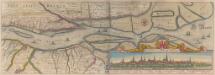
Nobilis Fluvius Albis maximâ curâ, ex variis famosisque Autoribus collectus, et in lucem editus. [Karte, Teil 2], in: Novus atlas absolutissimus, Bd. 2, S. 33.
1 Karte aus Atlas Janssonius Offizin
Nobilis Fluvius Albis maximâ curâ, ex variis, famosisque Autoribus collectus, et in lucem editus. [Karte, Teil 2], in: Gerardi Mercatoris et I. Hondii Newer Atlas, oder, Grosses Weltbuch, Bd. 1, S. 277.
1 Karte aus Atlas Mercator, Gerhard und Hondius, Jodocus Jansson, Jan
[left] DITHMARSIÆ | TABVLA; [right] DITHMARSIÆ | TABVLA
Auctore Joh: Meyer Husumensi | Anno 1559 Matthias & Nicolaus Peters | Goldtschmide gebr. Hus. sculps. [Amsterdam : Joan Blaeu]
Composite: 57. Rendsburg. (Germany)
1 : 100000 Reichsamt fur Landesaufnahme
DITHMARSIÆ | PARS SEPTENTRIONALIS [...]
author Iohannes Mejer Husum. | Regæ. Majis. Mathematicus Matthis Pet. v Clauß Peterss Goldtschmide unt gb. Hus. Cimbr. sculp. [Amsterdam : Joan Blaeu]
PRÆFECTVRÆ | GOTTORPIENSIS | PARS AVSTRALIS.
Matthias und Clauss Peters. | Goldtschmide und gbr. sculp. Husumens. [Amsterdam : Joan Blaeu]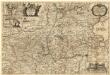
Landtcarte Uom Süderntheil des Wagerland's
1 : 130000 Mollova mapová sbírka Mejer, Johannes Rothgiesser, Andreas Lorenzen