Maps of Hamburg-Mitte

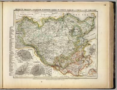
Holstein, Lauenburg, Lubeck, Hamburg.
1 : 440000 Meyer, Joseph, 1796-1856
[Herzogthum Holstein und Lauenburg, Fürstenthum Lübeck, Fr. Städte Hamburg und Lübeck nebst Amt Bergedorf]
Grosser Hand-Atlas über alle Theile der Erde in 170 Karten Meyer, J. Verlag des Bibliographischen Instituts

Holstein, Lauenburg, Hamburg, Lubeck.
1 : 435000 Flemming, Carl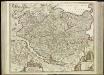
[45][45] Holsatiae tabula generalis ..., uit: Atlas sive Descriptio terrarum orbis
Annotatie: Gedigitaliseerde versie. Amsterdam. Heiloo : Picturae (vervaardiger), 2015. tiff-bestand. Gedigitaliseerd: 07-01-2015; Origineel: Universiteitsbibliotheek Vrije Universiteit (XL.05127.-) ; Netherlands; Titelpagina ontbreekt Wit, Frederik de Amsterdam : Frederick de Wit
Tabvla generalis Holsatiae complectens Holsatiae Dithmarsiae Stormariae et Vargiae dvcatvs
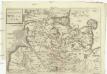
1 : 316000 Holštýnsko Homann, Johann Baptist a Ioh. Bapt. Homanno


Tabula Generalis Holsatiae
1 : 310000 Mollova mapová sbírka Danckerts, Theodorus Danckerts, Theodor
Tabvla Generalis Holsatiae complectens Holsatiae Dithmarsiae Stormariae et Vagriae Dvcatvs
1 : 310000 Mollova mapová sbírka Homann, Johann Baptist Homann, Johann Baptista
Tabvla Generalis Holsatiae complectens Holsatiae Dithmarsiae Stormariae et Vagriae Dvcatvs
1 : 310000 Mollova mapová sbírka Homann, Johann Baptist Homann, Johann Baptista
HOLSATIAE TABULA GENERALIS in qua sunt DUCATUS HOLSATIAE, DITHMARSIAE STORMARIAE et WAGRIAE
1 : 310000 Holštýnsko Wit, Frederick de Frederic de Wit
Holsatiae Dithmarsiae Stormariae et Vagriae Dvcatvs
1 : 480000 Mollova mapová sbírka Weigel, Christoph Kauffer, Michael Weigel, Christoph I.
Herzogthum Holstein im Nieder Sächsischen Creisse mit seinen abgetheilten Provintzien
Mollova mapová sbírka Weigel, Christoph Weigel, Christoph I.
Holsatiae Tabula Generalis in qua sunt Ducatus Holsatiae Ditmarsiae Stormariae et Wagriae
1 : 310000 Mollova mapová sbírka Schenk, Pieter Schenk, Peter I
Holsatia ducatus [Karte], in: Atlas, sive, Cosmographicae meditationes de fabrica mundi et fabricati figura, S. 141.
1 Karte aus Atlas Mercator, Gerhard
Holsatia ducatus [Karte], in: Gerardi Mercatoris Atlas, sive, Cosmographicae meditationes de fabrica mundi et fabricati figura, S. 146.
1 Karte aus Atlas Mercator, Gerhard Montanus, Petrus
Dvcatvs Holsatiae
Holštýnsko Bouttats, Gaspar
Ducatus Holsatiae Summa Diligentia Accurataq; Censura Noviter
1 : 570000 Mollova mapová sbírka Visscher, Nicolaes Goos, Abraham Visscher, Nicolaus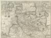
Dvcatvs Holsatiae Nova Tabvla
1 : 570000 Mollova mapová sbírka Blaeu, Willem Janszoon Blaeu, Willem Jansz.
Holsatiae descrip
1 Karte : Kupferdruck ; 32 x 23 cm Jorden; Ortelius s.n.
Holsatia ducatus
1 Karte : Kupferdruck ; 33 x 46 cm Mercator; Hondius Henricus Hondius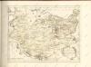

Dithmarsia Rendesburgum Kiel et Bordesholm in Occidentali parte Holsatiae
1 : 210000 Mollova mapová sbírka Schenk, Pieter Schenk, Peter I
Dithmarsia, Rendesburgum, Kiel et Bordesholm, in Occidentali parte Holsatiae. [Karte], in: Novus atlas absolutissimus, Bd. 1, S. 146.
1 Karte aus Atlas Janssonius Offizin
Hamburg 33, uit: Special-Karte von Mittel-Europa / nach amtlichen Quellen bearbeitet von W. Liebenow
1 : 300000 titelvariant: W. Liebenow's Mittel-Europa; Annotatie: Titel boven de bladen: W. Liebenow's Mittel-Europa Johannes Wilhelm Liebenow 1822-1897 Frankfurt a. M. : Ludwig Ravenstein
STORMARIA | DVCATVS
Auctore Joh: Meyer Husumensi. Matthias & Nicolaus Peters | Goldtschmide gebr. Hus. sculp. [Amsterdam : Joan Blaeu]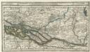
Hamburg mit dero Gegend Oostwerts bis Lauenburg Sampt denen in Gemeinschaft Lubeck besitzenden Vier Laendern.
1 : 320000 Mollova mapová sbírka Bodenehr, Gabriel Bodenehr, Gabriel