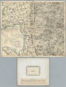
Maps of Mitteldithmarschen

80. Heide. (Germany)
1 : 100000 Reichsamt fur Landesaufnahme
Composite: 80. Heide. (Germany)
1 : 100000 Reichsamt fur Landesaufnahme
Meßtischblatt 567 : Meldorf, 1880
1 : 250000 Meldorf. - Aufn. 1878. - 1:25000. - [Berlin]: Reichsamt für Landesaufnahme, 1880. - 1 Kt.
Meßtischblatt 566, neue Nr. 1919 : Übersichtskarte des Adolf-Hitler-Kooges, 1935
1 : 250000 Übersichtskarte des Adolf-Hitler-Kooges. - Hrsg. 1935. - 1:25000. - [Berlin]: Reichsamt für Landesaufnahme, 1935. - 1 Kt.
Meßtischblatt 490 : Heide, 1896
1 : 250000 Heide. - Aufn. 1878, hrsg. 1880. - 1:25000. - [Berlin]: Reichsamt für Landesaufnahme, 1896. - 1 Kt.
Meßtischblatt 489 : Büsum, 1880
1 : 250000 Büsum. - Aufn. 1878. - 1:25000. - [Berlin]: Reichsamt für Landesaufnahme, 1880. - 1 Kt.
Meßtischblatt 568 : Süderhastedt, 1900
1 : 250000 Süderhastedt. - Aufn. 1878, hrsg. 1880, einz. Nachtr. 1900. - 1:25000. - [Berlin]: Reichsamt für Landesaufnahme, 1900. - 1 Kt.
Meßtischblatt 491 : Nordhastedt, 1895
1 : 250000 Nordhastedt. - Aufn. 1878, hrsg. 1880, einz. Nachtr. 1895. - 1:25000. - [Berlin]: Reichsamt für Landesaufnahme, 1895. - 1 Kt.
Dithmarsiae Tabvla
1 : 150000 Mollova mapová sbírka Mejer, Johannes Peters, Matthias Blaeu, Joan I.
Dithmarsiae Tabvla
1 : 150000 Mollova mapová sbírka Mejer, Johannes Peters, Matthias Blaeu, Joan I.
Thietmarsiae, Hosaticae Regionis Partis Typvs
1 : 200000 Mollova mapová sbírka Boekel, Peter
Thietmarsiae, Holsaticae Regionis Partis Typus. [Karte], in: Theatrum orbis terrarum, S. 58.
1 Karte aus Atlas Ortelius, Abraham
Thietmarsiae, Holsaticae Regionis Partis Typus. [Karte] , in: Theatrum orbis terrarum, S. 212.
1 Karte aus Atlas Ortelius, Abraham Vrients, Jan Baptista
[left] DITHMARSIÆ | TABVLA; [right] DITHMARSIÆ | TABVLA
Auctore Joh: Meyer Husumensi | Anno 1559 Matthias & Nicolaus Peters | Goldtschmide gebr. Hus. sculps. [Amsterdam : Joan Blaeu]
22. Husum, uit: Topographische Uebersichtskarte des Deutschen Reiches / herausgegeben v. d. Kartogr. Abt. d. Königl. Preuß. Landesaufnahme
1 : 200000 titelvariant: Topogr. Übersichtskarte des Deutschen Reiches; Annotatie: Titel boven bladen ook: Topogr. Übersichtskarte des Deutschen Reiches; Annotatie geografische gegevens: Op elk blad twee maatstokken: 10 Kilometer = 5,5 cm; 1 geogr. Meile = 3,6 cm; Legenda onder op elk blad Königlich Preußische Landesaufnahme. Kartographische Abtheilung [S.l : Königlich Preußische Landesaufnahme, Kartographische Abtheilung]
DITHMARSIÆ | PARS AVSTRALIS.
Authore Iohannes Mejer, Husum Reg.e Maj.is | Mathematicus Matthias und Nicolaus Peters Goldts. gebr. Hus. sculps. [Amsterdam : Joan Blaeu]
Thietmarsiae, Holsaticae regionis partis typvs
1 Karte : Kupferdruck ; 30 x 20 cm Boeckel; Ortelius s.n.
Thietmarsiae, Holsaticae regionis partis typvs
1 Karte : Kupferdruck ; 31 x 20 cm Boeckel; Ortelius s.n.
DITHMARSIÆ | PARS SEPTENTRIONALIS [...]
author Iohannes Mejer Husum. | Regæ. Majis. Mathematicus Matthis Pet. v Clauß Peterss Goldtschmide unt gb. Hus. Cimbr. sculp. [Amsterdam : Joan Blaeu]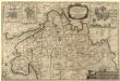
Dithmarsiae Pars Septentrionalis
1 : 75000 Mollova mapová sbírka Mejer, Johannes Peters, Matthias Blaeu, Joan I.
Meßtischblatt 419 : Wesselburen, 1928
1 : 250000 Wesselburen. - Hrsg. 1880, bericht. 1928. - 1:25000. - [Berlin]: Reichsamt für Landesaufnahme, 1928. - 1 Kt.
Meßtischblatt 420 : Weddingstedt, 1919
1 : 250000 Weddingstedt. - Aufn. 1878, kleine Nachtr. 1919. - 1:25000. - [Berlin]: Reichsamt für Landesaufnahme, 1919. - 1 Kt.
Meßtischblatt 421 : Tellingstedt, 1928
1 : 250000 Tellingstedt. - Hrsg. 1880, bericht. 1928. - 1:25000. - [Berlin]: Reichsamt für Landesaufnahme, 1928. - 1 Kt.
Meßtischblatt 488 : Blauort, 1880
1 : 250000 Blauort. - Aufn. 1878. - 1:25000. - [Berlin]: Reichsamt für Landesaufnahme, 1880. - 1 Kt.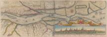
Nobilis Fluvius Albis maximâ curâ, ex variis famosisque Autoribus collectus, et in lucem editus. [Karte, Teil 2], in: Novus atlas absolutissimus, Bd. 2, S. 33.
1 Karte aus Atlas Janssonius Offizin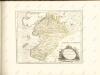

Dithmarsia, Rendesburgum, Kiel et Bordesholm, in Occidentali parte Holsatiae. [Karte], in: Novus atlas absolutissimus, Bd. 1, S. 146.
1 Karte aus Atlas Janssonius Offizin
Schleswig-Holstein
1 : 50000 Šlesvicko-Holštýnsko (Německo) Reichs-Marine-Amt
Dithmarsia Rendesburgum Kiel et Bordesholm in Occidentali parte Holsatiae
1 : 210000 Mollova mapová sbírka Schenk, Pieter Schenk, Peter I