Maps of Eiderstedt

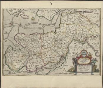
TERRITORIA | EIJDERSTEDE | Everschop | et | Uthholm.
Matthias und Nicolaus Pet. Goldtschmide gebr. | Husum. sculps. [Amsterdam : Joan Blaeu]
Composite: 56. Husum. (Germany)
1 : 100000 Reichsamt fur Landesaufnahme
Meßtischblatt 355 : Friedrichstadt, 1895
1 : 250000 Friedrichstadt. - Aufn. 1878, hrsg. 1880, einz. Nachtr. 1895. - 1:25000. - [Berlin]: Reichsamt für Landesaufnahme, 1895. - 1 Kt.
Meßtischblatt 354 : Tönning, 1910
1 : 250000 Tönning. - Aufn. 1878, hrsg. 1880, einz. Nachtr. 1910. - 1:25000. - [Berlin]: Reichsamt für Landesaufnahme, 1910. - 1 Kt.
Meßtischblatt 298 : Husum, 1931
1 : 250000 Husum. - Aufn. 1878, hrsg. 1880, berichtigt 1928. - 1:25000. - [Berlin]: Reichsamt für Landesaufnahme, 1931. - 1 Kt.
Meßtischblatt 297 : Simonsberg, 1897
1 : 250000 Simonsberg. - Aufn. 1878, hrsg. 1880, einz. Nachtr. 1897. - 1:25000. - [Berlin]: Reichsamt für Landesaufnahme, 1897. - 1 Kt.
Meßtischblatt 296 : Südfall, 1928
1 : 250000 Südfall. - Hrsg. 1880, bericht. 1927/28. - 1:25000. - [Berlin]: Reichsamt für Landesaufnahme, 1928. - 1 Kt.
Tönningen.
Mollova mapová sbírka Bodenehr, Gabriel Bodenehr, Gabriel
Meßtischblatt 420 : Weddingstedt, 1919
1 : 250000 Weddingstedt. - Aufn. 1878, kleine Nachtr. 1919. - 1:25000. - [Berlin]: Reichsamt für Landesaufnahme, 1919. - 1 Kt.
Meßtischblatt 419 : Wesselburen, 1928
1 : 250000 Wesselburen. - Hrsg. 1880, bericht. 1928. - 1:25000. - [Berlin]: Reichsamt für Landesaufnahme, 1928. - 1 Kt.
Meßtischblatt 418 : Vollerwiek, 1916
1 : 250000 Vollerwiek. - Aufn. 1878, hrsg. 1880, Aufldr. 1916. - 1:25000. - [Berlin]: Reichsamt für Landesaufnahme, 1916. - 1 Kt.
22. Husum, uit: Topographische Uebersichtskarte des Deutschen Reiches / herausgegeben v. d. Kartogr. Abt. d. Königl. Preuß. Landesaufnahme
1 : 200000 titelvariant: Topogr. Übersichtskarte des Deutschen Reiches; Annotatie: Titel boven bladen ook: Topogr. Übersichtskarte des Deutschen Reiches; Annotatie geografische gegevens: Op elk blad twee maatstokken: 10 Kilometer = 5,5 cm; 1 geogr. Meile = 3,6 cm; Legenda onder op elk blad Königlich Preußische Landesaufnahme. Kartographische Abtheilung [S.l : Königlich Preußische Landesaufnahme, Kartographische Abtheilung]
DITHMARSIÆ | PARS SEPTENTRIONALIS [...]
author Iohannes Mejer Husum. | Regæ. Majis. Mathematicus Matthis Pet. v Clauß Peterss Goldtschmide unt gb. Hus. Cimbr. sculp. [Amsterdam : Joan Blaeu]
56. Husum. (Germany)
1 : 100000 Reichsamt fur Landesaufnahme
Composite: 55. Garding. (Germany)
1 : 100000 Reichsamt fur Landesaufnahme
55. Garding. (Germany)
1 : 100000 Reichsamt fur Landesaufnahme
Dithmarsiae Pars Septentrionalis
1 : 75000 Mollova mapová sbírka Mejer, Johannes Peters, Matthias Blaeu, Joan I.
Meßtischblatt 1617, 1618 : Übersichtskarte des Hermann-Göring-Kooges, 1935
1 : 250000 Übersichtskarte des Hermann-Göring-Kooges. - Hrsg. 1935. - 1:25000. - [Berlin]: Reichsamt für Landesaufnahme, 1935. - 1 Kt.
Meßtischblatt 295, neue Nr. 1517 : Süderoog, 1936
1 : 250000 Süderoog. - Hrsg. 1880, bericht. 1927, mehrfarb. Ausg. 1936. - 1:25000. - [Berlin]: Reichsamt für Landesaufnahme, 1936. - 1 Kt.
Meßtischblatt 417, neue Nr. 1717 : Böhl (Kreis Husum-Eiderstedt), 1936
1 : 250000 Böhl (Kreis Husum-Eiderstedt). - Hrsg. 1880, bericht. 1928. - 1:25000. - [Berlin]: Reichsamt für Landesaufnahme, 1936. - 1 Kt.

Szleswig
Deutschland Dänemark Regierungsbezirk Schleswig Grenze Wierzbicki, B.
[left] FRISIA BOREALIS | IN DVCATV SLESWICENSI | sive FRISIA CIMBRICA | Anno 1651. [right] FRISIA BOREALIS | IN DVCATV SLESWICENSI | Anno 1240. | Frisia Cimbrica Antiqua.
Matthias & Nicolao Peters | Goldtschmide gbr. Husum. sculps. [Amsterdam : Joan Blaeu]
Tönning 20, uit: Special-Karte von Mittel-Europa / nach amtlichen Quellen bearbeitet von W. Liebenow
1 : 300000 titelvariant: W. Liebenow's Mittel-Europa; Annotatie: Titel boven de bladen: W. Liebenow's Mittel-Europa Johannes Wilhelm Liebenow 1822-1897 Frankfurt a. M. : Ludwig Ravenstein
Tönning 20, uit: [W. Liebenow's Special-Karte von Mittel-Europa]
1 : 300000 titelvariant: W. Liebenow's Mittel-Europa; Annotatie: Titel boven de bladen: W. Liebenow's Mittel-Europa Johannes Wilhelm Liebenow 1822-1897 Hannover : Hermann Oppermann
Dithmarsia, Rendesburgum, Kiel et Bordesholm, in Occidentali parte Holsatiae. [Karte], in: Novus atlas absolutissimus, Bd. 1, S. 146.
1 Karte aus Atlas Janssonius Offizin
Dithmarsia Rendesburgum Kiel et Bordesholm in Occidentali parte Holsatiae
1 : 210000 Mollova mapová sbírka Schenk, Pieter Schenk, Peter I
[left] DITHMARSIÆ | TABVLA; [right] DITHMARSIÆ | TABVLA
Auctore Joh: Meyer Husumensi | Anno 1559 Matthias & Nicolaus Peters | Goldtschmide gebr. Hus. sculps. [Amsterdam : Joan Blaeu]
PRÆFECTURA | HVSVMENSIS | LVNDERBERGH NORDSTRAND | et NORDGOESHERDE.
Matthias Vnd Clauss Petersen | G.S. gebr. | Husumenss. sculps. [Amsterdam : Joan Blaeu]