Maps of Rendsburg-Eckernförde

Kiel 21, uit: [W. Liebenow's Special-Karte von Mittel-Europa]
1 : 300000 titelvariant: W. Liebenow's Mittel-Europa; Annotatie: Titel boven de bladen: W. Liebenow's Mittel-Europa Johannes Wilhelm Liebenow 1822-1897 Hannover : Hermann Oppermann
Kiel 21, uit: Special-Karte von Mittel-Europa / nach amtlichen Quellen bearbeitet von W. Liebenow
1 : 300000 titelvariant: W. Liebenow's Mittel-Europa; Annotatie: Titel boven de bladen: W. Liebenow's Mittel-Europa Johannes Wilhelm Liebenow 1822-1897 Frankfurt a. M. : Ludwig Ravenstein
Das oestliche Holstein

Special-Karte von Süd-Schleswig
1 : 150000 Šlesvicko Petermann, August Justus Perthes
Special-Karte von Süd-Schleswig
1 : 150000 Šlesvicko Petermann, August Friedrich Ehrlich
Special-Karte von Süd-Schleswig
1 : 150000 Šlesvicko Petermann, August Justus Perthes
23. Kiel, uit: Topographische Uebersichtskarte des Deutschen Reiches / herausgegeben v. d. Kartogr. Abt. d. Königl. Preuß. Landesaufnahme
1 : 200000 titelvariant: Topogr. Übersichtskarte des Deutschen Reiches; Annotatie: Titel boven bladen ook: Topogr. Übersichtskarte des Deutschen Reiches; Annotatie geografische gegevens: Op elk blad twee maatstokken: 10 Kilometer = 5,5 cm; 1 geogr. Meile = 3,6 cm; Legenda onder op elk blad Königlich Preußische Landesaufnahme. Kartographische Abtheilung [S.l : Königlich Preußische Landesaufnahme, Kartographische Abtheilung]
PRÆFECTVRÆ | GOTTORPIENSIS | PARS AVSTRALIS.
Matthias und Clauss Peters. | Goldtschmide und gbr. sculp. Husumens. [Amsterdam : Joan Blaeu]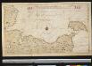
Het Zuijdelijkste gedeelte van de Beld, van de Riv. Sleeswijk tot t eijl. Femeren
Germany Gerard van Keulen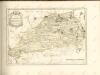

RENDSBVRGVM, | CHILONVM et BORDESHOLMA, | sive | HOLSATIA PROPRIA.
Christian Lorensen | Rodtgiesser Husum | sculpsit [Amsterdam : Joan Blaeu]
10. Schleswig, uit: Topographische Uebersichtskarte des Deutschen Reiches / herausgegeben v. d. Kartogr. Abt. d. Königl. Preuß. Landesaufnahme
1 : 200000 titelvariant: Topogr. Übersichtskarte des Deutschen Reiches; Annotatie: Titel boven bladen ook: Topogr. Übersichtskarte des Deutschen Reiches; Annotatie geografische gegevens: Op elk blad twee maatstokken: 10 Kilometer = 5,5 cm; 1 geogr. Meile = 3,6 cm; Legenda onder op elk blad Königlich Preußische Landesaufnahme. Kartographische Abtheilung [S.l : Königlich Preußische Landesaufnahme, Kartographische Abtheilung]
PRÆFECTVRÆ | GOTTORPIENSIS | pars Borealis.
Matthias und Clauss Petersen | Goldtschmide gebr. Hus. sculps. [Amsterdam : Joan Blaeu]
57. Rendsburg. (Germany)
1 : 100000 Reichsamt fur Landesaufnahme
Composite: 57. Rendsburg. (Germany)
1 : 100000 Reichsamt fur Landesaufnahme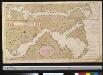
Afteekening van de Rivier van Sleeswijck waer bij dessefls incomen int grood wort vertoont geleegen in de Beldt
Germany Gerard van Keulen
38. Schleswig. (Germany)
1 : 100000 Reichsamt fur Landesaufnahme
58. Kiel. (Germany)
1 : 100000 Reichsamt fur Landesaufnahme
TERRITORIA | ANGLEN | ET | SCHWANSEN | Anno 1649
Matthias und Clauss Petersen Goldtschmide und gebr. | Hus. Cimb. sculps. [Amsterdam : Joan Blaeu]
Composite: 58. Kiel. (Germany)
1 : 100000 Reichsamt fur Landesaufnahme
39. Kappeln. (Germany)
1 : 100000 Reichsamt fur Landesaufnahme
Composite: 38. Schleswig. (Germany)
1 : 100000 Reichsamt fur Landesaufnahme
SYLVA DANICA | vulgo | DÆNISCHEN WALDE.
[Amsterdam : Joan Blaeu]
Composite: 39. Kappeln. (Germany)
1 : 100000 Reichsamt fur Landesaufnahme
Composite: 81. Hademarschen. (Germany)
1 : 100000 Reichsamt fur Landesaufnahme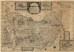
Wagriae Pars Septentrionalis cum praefectura Cismar et Oldenbvrgh
1 : 130000 Mollova mapová sbírka Mejer, Johannes Rothgiesser, Christian Lorenzen Blaeu, Joan I.
PRÆFECTVRA | FLENSBVRGENSIS | absque Nordgoeßherde.
Matthias & Nicolas Peters Goldtschmide | gebr. Husum. sculps. [Amsterdam : Joan Blaeu]
Praefectvra Flensbvrgensis absque Nordgoeßherde
1 : 110000 Mollova mapová sbírka Mejer, Johannes Peters, Matthias Blaeu, Joan I.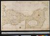
Een gedeelte van de kust van Holsteijn van Kijll of Kielerford tot Femere of New Stadt in de Belt Oost Zee
Germany Gerard van Keulen
![Kiel 21, uit: [W. Liebenow's Special-Karte von Mittel-Europa]](https://images-2.georeferencer.com/images/iiif/552217174959/full/,300/0/native.jpg)

