Maps of Northern Ireland

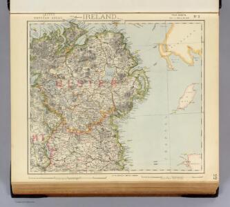
Ireland 2.
1 : 760320 Letts, Son & Co.
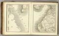
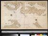
A chart of the sea coast of IRELAND from Dublin to London-Derry
from The sea-atlas : containing an hydrographical description of most of the sea-coasts of the known parts of the world.
Ireland NE.
1 : 486830 Stanford, Edward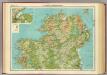
Ireland - northern section.
1 : 633600 John Bartholomew & Co.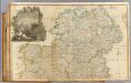
Ireland (north)
1 : 380000 Rocque, John
Vltonia; hibernis Cvi-Gvilly; anglis Vlster
1 Karte : Kupferdruck ; 40 x 48 cm Blaeu Joan Blaeu
Provincia Ultoniae The Province of Ulster [Karte], in: Novus atlas absolutissimus, Bd. 8, S. 201.
1 Karte aus Atlas Janssonius Offizin
Provincia Ultoniae The Province of Ulster [Karte], in: Gerardi Mercatoris et I. Hondii Newer Atlas, oder, Grosses Weltbuch, Bd. 1, S. 63.
1 Karte aus Atlas Mercator, Gerhard und Hondius, Jodocus Jansson, Jan
Provincia Ultoniae = The province of Ulster
1 : 690000 Amstelodami : apud Joannem Janssonium
Ultoniae Orientalis. Pars [Karte], in: Gerardi Mercatoris Atlas, sive, Cosmographicae meditationes de fabrica mundi et fabricati figura, S. 94.
1 Karte aus Atlas Mercator, Gerhard Montanus, Petrus
VLTONIA; | Hibernis CUI-GUILLY; | Anglis VLSTER.
[Amsterdam : Joan Blaeu]
Belfast
1 : 250000 Belfast (Severní Irsko) War Office
Ultoniae Orientalis. Pars [Karte], in: Atlas, sive, Cosmographicae meditationes de fabrica mundi et fabricati figura, S. 101.
1 Karte aus Atlas Mercator, Gerhard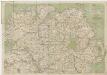
[Kaart], uit: Cycling map of Ireland : north sheet
1 : 400000 London : Bacon
Vltoniae orientalis. pars
1 Karte : Kupferdruck ; 33 x 36 cm Mercator; Hondius Henricus Hondius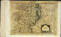
Vltoniæ orientalis pars
1 Karte : Kupferdruck ; 17 x 24 cm Mercator Cloppenburgh
Vltoniae orientalis. pars
1 Karte : Kupferdruck ; 33 x 36 cm Mercator; Hondius Jodocus Hondius
delineation of the strata of England and Wales, with part of Scotland
1 : 320000 Blatt 3 Smith, William Cary
Ulster
This is a map of the six ‘escheated’ counties of Ulster. It dates from 1609 and may be by John Norden, though likely to be based on the barony maps of Josias Bodley and William Parsons. It seems to be intended as a guide to planned plantings. In 1607 the earls of Ulster fled and the counties of Armagh, Cavan, Coleraine, Donegal, Fermanagh and Tyrone were confiscated by the English and the Scots. In 1608-9 the Commons had drafted plans for English and Scottish planting and lands that were to be retained by the Irish. Norden, John
Vltoniae orientalis
1 : 316800
Bartholomew's Quarter-inch to mile" map of Ireland
1 : 253440 Belfast (Severní Irsko) Geographical Institute
De Noord Oost kust van IJrlandt
Ireland Gerard van Keulen
Sheet 8, uit: Ireland
1 : 253440 Annotatie: Voor aanwezige bladen zie overzichtsblad; Alle bladen met aantekeningen in kleurpotlood of inkt; Annotatie geografische gegevens: Maps on the scale of four miles to one inch; Op elk blad een diagram van aangrenzende bladen en een indexdiagram van de corresponderende bladen van de 'one inch map' Dublin : Ordnance Survey of Ireland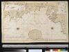
Een gedeelte van de Oost kust van IJrland van Dublin tot St. Johns Point
Ireland Gerard van Keulen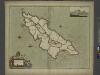
To the Honorable William, E. of Derby lord of ISLE of MAN
from The sea-atlas : containing an hydrographical description of most of the sea-coasts of the known parts of the world.
GALLOVIDIÆ | Pars Occidentalior, | in qua | VICECOMITATVS VICTONIENSIS | cum Regalitate Glenlucensi. [=] The Sherifdome of Wigtoun | wt the Regalitie of Glen-Luze | both in Galloway.
Auct. Timoth. Pont. [Amsterdam : Joan Blaeu]
Sheet 46. (Cary's England, Wales, and Scotland).
1 : 360000 Cary, John, ca. 1754-1835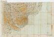
Sheet 9 Newry, uit: Ireland
1 : 126720 Annotatie: Enkele bladen dubbel. - Enkele bladen van een oudere uitg; De bladen 5 (1912) en 9 (1918) opgeborgen bij gevouwen kaarten. - Beide bladen met aantekeningen in rode en zwarte inkt; Annotatie geografische gegevens: Reduced from the one inch map; Met diagram van aangrenzende bladen, indexdiagram van de corresponderende bladen van de 'one inch map' en diagram van 'The National Grid' Dublin : Ordnance Survey of Ireland