Maps of Dublin

Maps of Dublin

$title$

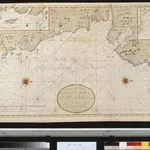
Een gedeelte van de Oost kust van IJrland van Dublin tot St. Johns Point

Ireland Gerard van Keulen
$title$

Sheet 46. (Cary's England, Wales, and Scotland).

1 : 360000 Cary, John, ca. 1754-1835
$title$

Sheet 9 Newry, uit: Ireland

1 : 126720 Annotatie: Enkele bladen dubbel. - Enkele bladen van een oudere uitg; De bladen 5 (1912) en 9 (1918) opgeborgen bij gevouwen kaarten. - Beide bladen met aantekeningen in rode en zwarte inkt; Annotatie geografische gegevens: Reduced from the one inch map; Met diagram van aangrenzende bladen, indexdiagram van de corresponderende bladen van de 'one inch map' en diagram van 'The National Grid' Dublin : Ordnance Survey of Ireland
$title$

Dublin environs.

1 : 85000 Society for the Diffusion of Useful Knowledge (Great Britain)
$title$

Sheet 11 The Mourne Mountains, uit: [Northern Ireland] : one-inch popular edition

1 : 63360 titelvariant: One-inch popular edition; One-inch popular series; Annotatie: Serietitel op omslag: One-inch popular series; Voor aanwezige bladen zie bladoverzicht; Sommige bladen met gaas verstevigd; Annotatie geografische gegevens: Met twee maatstokken (miles/yards en kilometres); Met indexkaartje op elk blad Belfast : Ordnance Survey of Northern Ireland
$title$

Geological map Dublin.

1 : 47520 Letts, Son & Co.
$title$

The environs of Dublin

1 : 15250 Davies, Benjamin Rees published under the superindentance of the Society for the Diffusion of Useful Knowledge [by] George Cox
$title$

De baaij of rivier van Dublin geleegen aen de Oostcust van Irlandt

Ireland Gerard van Keulen
$title$

Afteekening vande rivier van Carlingfort geleegen aen de Oost kust van IJrlandt

Ireland Gerard van Keulen
$title$

Irish Ports & Harbours.

1 : 887040 Fullarton, A. & Co.
$title$

A plan of the city of Dublin and the environs on the same scale of London, Paris, & Rome = Plan de Dublin et de ces environs sur la meme echelle de ceux de Londres, Paris, et Rome

1 : 2500 Rocque, John, d. 1762 J. Rocque
$title$

Plan for a complete new harbour, at Howth-town, for the use of his Majesty's mail packet-boats, fishing vessels & in case of a storm, merchant ships going to & fm. Dublin

1 : 44350
$title$

Dublin

1 : 85250 Clarke, W. B published under superintendance of the Society of the Diffusion of Useful Knowledge [by] George Cox
$title$

A plan of the city of Dublin : as surveyed for the use of the division[a]l justices to which have been added plans of the canal harbour and its junction with the Grand Canal, the Royal Canal, and every projection and alteration to the present time, 1797

1 : 7250 Faden, William, 1749-1836 W. Faden ; Sold by W. Allen & J. Archer
$title$

Plan of the city of Dublin

1 : 13000 Dublin (Irsko) Lizars, W. H. by W.H. Lizars
$title$

Cooke ́s royal map of Dublin

$title$

Plan of Dublin

1 : 25000 [London] : Leigh & Son
$title$

Plan of the city of Dublin : taken from an actual survey from the Universal Scots Almanack

1 : 1200 Robertson, John, fl. 1760-1790 printed by John Robertson
$title$

Insurance Plan of the City of Dublin Vol. 1: Key Plan

1 : 7200 This "key plan" indicates coverage of the Goad 1893 series of fire insurance maps of Dublin that were originally produced to aid insurance companies in assessing fire risks. The building footprints, their use (commercial, residential, educational, etc.), the number of floors and the height of the building, as well as construction materials (and thus risk of burning) and special fire hazards (chemicals, kilns, ovens) were documented in order to estimate premiums. Names of individual businesses, property lines, and addresses were also often recorded. Together these maps provide a rich historical shapshot of the commercial activity and urban landscape of towns and cities at the time. The British Library holds a comprehensive collection of fire insurance plans produced by the London-based firm Charles E. Goad Ltd. dating back to 1885. These plans were made for most important towns and cities of the British Isles at the scales of 1:480 (1 inch to 40 feet), as well as many foreign towns at 1:600 (1 inch to 50 feet). Chas E Goad Limited Chas E Goad Limited
$title$

An exact survey of the city and suburbs of Dublin : in which is express'd the ground plot of all publick buildings, dwelling houses, ware houses, stables, courts, yards &c

1 : 2450 Rocque, John, d. 1762 John Rocque
$title$

Dublin

1 Plan : Kupferdruck ; 11 x 18 cm Le Rouge Georges Louis Le Rouge
$title$

Insurance Plan of the City of Dublin Vol. 1: sheet 12-2

1 : 960 This detailed 1893 plan of Dublin is one of a series of twenty sheets in an atlas originally produced to aid insurance companies in assessing fire risks. The building footprints, their use (commercial, residential, educational, etc.), the number of floors and the height of the building, as well as construction materials (and thus risk of burning) and special fire hazards (chemicals, kilns, ovens) were documented in order to estimate premiums. Names of individual businesses, property lines, and addresses were also often recorded. Together these maps provide a rich historical shapshot of the commercial activity and urban landscape of towns and cities at the time. The British Library holds a comprehensive collection of fire insurance plans produced by the London-based firm Charles E. Goad Ltd. dating back to 1885. These plans were made for most important towns and cities of the British Isles at the scales of 1:480 (1 inch to 40 feet), as well as many foreign towns at 1:600 (1 inch to 50 feet). Chas E Goad Limited Chas E Goad Limited
$title$

Insurance Plan of the City of Dublin Vol. 1: sheet 12-1

1 : 960 This detailed 1893 plan of Dublin is one of a series of twenty sheets in an atlas originally produced to aid insurance companies in assessing fire risks. The building footprints, their use (commercial, residential, educational, etc.), the number of floors and the height of the building, as well as construction materials (and thus risk of burning) and special fire hazards (chemicals, kilns, ovens) were documented in order to estimate premiums. Names of individual businesses, property lines, and addresses were also often recorded. Together these maps provide a rich historical shapshot of the commercial activity and urban landscape of towns and cities at the time. The British Library holds a comprehensive collection of fire insurance plans produced by the London-based firm Charles E. Goad Ltd. dating back to 1885. These plans were made for most important towns and cities of the British Isles at the scales of 1:480 (1 inch to 40 feet), as well as many foreign towns at 1:600 (1 inch to 50 feet). Chas E Goad Limited Chas E Goad Limited
$title$

Insurance Plan of the City of Dublin Vol. 1: sheet 13-1

1 : 960 This detailed 1893 plan of Dublin is one of a series of twenty sheets in an atlas originally produced to aid insurance companies in assessing fire risks. The building footprints, their use (commercial, residential, educational, etc.), the number of floors and the height of the building, as well as construction materials (and thus risk of burning) and special fire hazards (chemicals, kilns, ovens) were documented in order to estimate premiums. Names of individual businesses, property lines, and addresses were also often recorded. Together these maps provide a rich historical shapshot of the commercial activity and urban landscape of towns and cities at the time. The British Library holds a comprehensive collection of fire insurance plans produced by the London-based firm Charles E. Goad Ltd. dating back to 1885. These plans were made for most important towns and cities of the British Isles at the scales of 1:480 (1 inch to 40 feet), as well as many foreign towns at 1:600 (1 inch to 50 feet). Chas E Goad Limited Chas E Goad Limited
$title$

Insurance Plan of the City of Dublin Vol. 1: sheet 14

1 : 480 This detailed 1893 plan of Dublin is one of a series of twenty sheets in an atlas originally produced to aid insurance companies in assessing fire risks. The building footprints, their use (commercial, residential, educational, etc.), the number of floors and the height of the building, as well as construction materials (and thus risk of burning) and special fire hazards (chemicals, kilns, ovens) were documented in order to estimate premiums. Names of individual businesses, property lines, and addresses were also often recorded. Together these maps provide a rich historical shapshot of the commercial activity and urban landscape of towns and cities at the time. The British Library holds a comprehensive collection of fire insurance plans produced by the London-based firm Charles E. Goad Ltd. dating back to 1885. These plans were made for most important towns and cities of the British Isles at the scales of 1:480 (1 inch to 40 feet), as well as many foreign towns at 1:600 (1 inch to 50 feet). Chas E Goad Limited Chas E Goad Limited
$title$

Insurance Plan of the City of Dublin Vol. 1: sheet 3

1 : 480 This detailed 1893 plan of Dublin is one of a series of twenty sheets in an atlas originally produced to aid insurance companies in assessing fire risks. The building footprints, their use (commercial, residential, educational, etc.), the number of floors and the height of the building, as well as construction materials (and thus risk of burning) and special fire hazards (chemicals, kilns, ovens) were documented in order to estimate premiums. Names of individual businesses, property lines, and addresses were also often recorded. Together these maps provide a rich historical shapshot of the commercial activity and urban landscape of towns and cities at the time. The British Library holds a comprehensive collection of fire insurance plans produced by the London-based firm Charles E. Goad Ltd. dating back to 1885. These plans were made for most important towns and cities of the British Isles at the scales of 1:480 (1 inch to 40 feet), as well as many foreign towns at 1:600 (1 inch to 50 feet). Chas E Goad Limited Chas E Goad Limited
$title$

Insurance Plan of the City of Dublin Vol. 1: sheet 4

1 : 480 This detailed 1893 plan of Dublin is one of a series of twenty sheets in an atlas originally produced to aid insurance companies in assessing fire risks. The building footprints, their use (commercial, residential, educational, etc.), the number of floors and the height of the building, as well as construction materials (and thus risk of burning) and special fire hazards (chemicals, kilns, ovens) were documented in order to estimate premiums. Names of individual businesses, property lines, and addresses were also often recorded. Together these maps provide a rich historical shapshot of the commercial activity and urban landscape of towns and cities at the time. The British Library holds a comprehensive collection of fire insurance plans produced by the London-based firm Charles E. Goad Ltd. dating back to 1885. These plans were made for most important towns and cities of the British Isles at the scales of 1:480 (1 inch to 40 feet), as well as many foreign towns at 1:600 (1 inch to 50 feet). Chas E Goad Limited Chas E Goad Limited
$title$

Insurance Plan of the City of Dublin Vol. 1: sheet 9

1 : 480 This detailed 1893 plan of Dublin is one of a series of twenty sheets in an atlas originally produced to aid insurance companies in assessing fire risks. The building footprints, their use (commercial, residential, educational, etc.), the number of floors and the height of the building, as well as construction materials (and thus risk of burning) and special fire hazards (chemicals, kilns, ovens) were documented in order to estimate premiums. Names of individual businesses, property lines, and addresses were also often recorded. Together these maps provide a rich historical shapshot of the commercial activity and urban landscape of towns and cities at the time. The British Library holds a comprehensive collection of fire insurance plans produced by the London-based firm Charles E. Goad Ltd. dating back to 1885. These plans were made for most important towns and cities of the British Isles at the scales of 1:480 (1 inch to 40 feet), as well as many foreign towns at 1:600 (1 inch to 50 feet). Chas E Goad Limited Chas E Goad Limited
$title$

Insurance Plan of the City of Dublin Vol. 1: sheet 6

1 : 480 This detailed 1893 plan of Dublin is one of a series of twenty sheets in an atlas originally produced to aid insurance companies in assessing fire risks. The building footprints, their use (commercial, residential, educational, etc.), the number of floors and the height of the building, as well as construction materials (and thus risk of burning) and special fire hazards (chemicals, kilns, ovens) were documented in order to estimate premiums. Names of individual businesses, property lines, and addresses were also often recorded. Together these maps provide a rich historical shapshot of the commercial activity and urban landscape of towns and cities at the time. The British Library holds a comprehensive collection of fire insurance plans produced by the London-based firm Charles E. Goad Ltd. dating back to 1885. These plans were made for most important towns and cities of the British Isles at the scales of 1:480 (1 inch to 40 feet), as well as many foreign towns at 1:600 (1 inch to 50 feet). Chas E Goad Limited Chas E Goad Limited
$title$

Insurance Plan of the City of Dublin Vol. 1: sheet 7

1 : 480 This detailed 1893 plan of Dublin is one of a series of twenty sheets in an atlas originally produced to aid insurance companies in assessing fire risks. The building footprints, their use (commercial, residential, educational, etc.), the number of floors and the height of the building, as well as construction materials (and thus risk of burning) and special fire hazards (chemicals, kilns, ovens) were documented in order to estimate premiums. Names of individual businesses, property lines, and addresses were also often recorded. Together these maps provide a rich historical shapshot of the commercial activity and urban landscape of towns and cities at the time. The British Library holds a comprehensive collection of fire insurance plans produced by the London-based firm Charles E. Goad Ltd. dating back to 1885. These plans were made for most important towns and cities of the British Isles at the scales of 1:480 (1 inch to 40 feet), as well as many foreign towns at 1:600 (1 inch to 50 feet). Chas E Goad Limited Chas E Goad Limited
© MapTiler © OpenStreetMap contributors
How does it work?
These instructions will show you how to find historical maps online.
Getting started
Type the place name in the search box to find the exact location. You can further adjust the search by zooming in and out.
Zoom
Zoom in and out with the buttons or use your mouse or touchpad natively.
Exact Area tool
Click here and draw a rectangle over the map to precisely define the search area.
Set filters
Narrow your search with advanced settings, such as Years (from/to), Fulltext, Publisher, etc.
Results
See the results of your search on the right side. You can scroll down to find more maps of this location.
?

Download OldMapsOnline Mobile