Maps of Louth

delineation of the strata of England and Wales, with part of Scotland
1 : 320000 Blatt 3 Smith, William Cary
Ultoniae Orientalis. Pars [Karte], in: Gerardi Mercatoris Atlas, sive, Cosmographicae meditationes de fabrica mundi et fabricati figura, S. 94.
1 Karte aus Atlas Mercator, Gerhard Montanus, Petrus
Ultoniae Orientalis. Pars [Karte], in: Atlas, sive, Cosmographicae meditationes de fabrica mundi et fabricati figura, S. 101.
1 Karte aus Atlas Mercator, Gerhard
Vltoniae orientalis. pars
1 Karte : Kupferdruck ; 33 x 36 cm Mercator; Hondius Henricus Hondius
Vltoniæ orientalis pars
1 Karte : Kupferdruck ; 17 x 24 cm Mercator Cloppenburgh
Vltoniae orientalis. pars
1 Karte : Kupferdruck ; 33 x 36 cm Mercator; Hondius Jodocus Hondius

Bartholomew's Quarter-inch to mile" map of Ireland
1 : 253440 Belfast (Severní Irsko) Geographical Institute
De Noord Oost kust van IJrlandt
Ireland Gerard van Keulen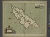
To the Honorable William, E. of Derby lord of ISLE of MAN
from The sea-atlas : containing an hydrographical description of most of the sea-coasts of the known parts of the world.
Sheets 56-57. (Cary's England, Wales, and Scotland).
1 : 360000 Cary, John, ca. 1754-1835
Sheets 47-48. (Cary's England, Wales, and Scotland).
1 : 360000 Cary, John, ca. 1754-1835
Mona Insula: Vulgo The Isle of Man. [Karte], in: Novus atlas absolutissimus, Bd. 8, S. 104.
1 Karte aus Atlas Janssonius Offizin
Sheet 46. (Cary's England, Wales, and Scotland).
1 : 360000 Cary, John, ca. 1754-1835
Sheet 9 Newry, uit: Ireland
1 : 126720 Annotatie: Enkele bladen dubbel. - Enkele bladen van een oudere uitg; De bladen 5 (1912) en 9 (1918) opgeborgen bij gevouwen kaarten. - Beide bladen met aantekeningen in rode en zwarte inkt; Annotatie geografische gegevens: Reduced from the one inch map; Met diagram van aangrenzende bladen, indexdiagram van de corresponderende bladen van de 'one inch map' en diagram van 'The National Grid' Dublin : Ordnance Survey of Ireland
Mona. [Karte], in: Le théâtre du monde, ou, Nouvel atlas contenant les chartes et descriptions de tous les païs de la terre, Bd. 4, S. 442.
1 Karte aus Atlas Blaeu, Willem Janszoon und Blaeu, Joan Blaeu, Willem Janszoon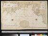
Een gedeelte van de Oost kust van IJrland van Dublin tot St. Johns Point
Ireland Gerard van Keulen
MONA.
[Amsterdam : Joan Blaeu]
Mona. [Karte], in: Theatrum orbis terrarum, sive, Atlas novus, Bd. 4, S. 521.
1 Karte aus Atlas Blaeu, Joan Blaeu, Willem Janszoon
Mona. [Karte], in: Theatrum orbis terrarum, sive, Atlas novus, Bd. 4, S. 521.
1 Karte aus Atlas Blaeu, Joan Blaeu, Willem Janszoon
Sheet 55. (Cary's England, Wales, and Scotland).
1 : 360000 Cary, John, ca. 1754-1835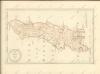

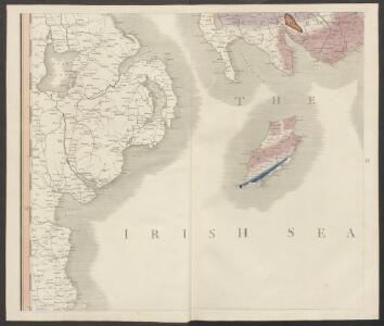
Isle of Man - OS One-Inch Map
1 : 63360 Topographic maps Ordnance Survey Ordnance Survey
Firth of Solway to Loch Ryan.
Great Britain. Hydrographic Office
Isle of Man (Outline) - OS One-Inch Revised New Series
1 : 63360 Topographic maps Ordnance Survey Ordnance Survey
Isle of Man (Outline) - OS One-Inch Revised New Series
1 : 63360 Topographic maps Ordnance Survey Ordnance Survey
Isle of Man (Hills) - OS One-Inch Revised New Series
1 : 63360 Topographic maps Ordnance Survey Ordnance Survey
Sheet 8, uit: Ireland
1 : 253440 Annotatie: Voor aanwezige bladen zie overzichtsblad; Alle bladen met aantekeningen in kleurpotlood of inkt; Annotatie geografische gegevens: Maps on the scale of four miles to one inch; Op elk blad een diagram van aangrenzende bladen en een indexdiagram van de corresponderende bladen van de 'one inch map' Dublin : Ordnance Survey of Ireland
A map of the county of Armagh, with the harbours of Dundalk and Carlingford
This is a map of North East Ireland dating from 1600. An inset in the lower right hand corner shows the fortification of Fort Mount Norris. It is a remarkably detailed pen and ink rendering of the area between Lough Neagh and Dundalk. Details include vignette view of fortifications, fortified towns and churches, mountains in elevation, the names of local chieftains and plans of forts. It illustrates the campaign of 1600 which lead to the success of the Lord Deputy in forcing his way into the territory of the Irish leader O’Neill, although he was not able to penetrate further than Mount Norris between Newy and Armagh. By 1603 O’Neill and his allies among the Ulster Lords had been defeated and the entry of the English to the hitherto almost unknown area of central Ulster was then possible. This event explains why English topographical knowledge of this area suddenly increased in the first years of the 17th century. The cartographer of this map is thought to be Richard Barthelett who was the first cartographer to profit from this opportunity to complete the survey of Ireland. Barthelett was killed by Irish natives while surveying in Donegall in 1603 ‘because they would not have their land discovered’. It is interesting to note that Barthelett’s work was so accurate that it satisfies 18th century specification for military mapping. The formula of cartographic representation which he adopted matches that used by military engineers two centuries later. scale bar of 8 miles = 4" (1:120,000) inset 1":40 foot. Barthelett, Richard