Maps of Northern Ireland

Maps of Northern Ireland

$title$

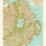
Bartholomew's Quarter-inch to mile" map of Ireland

1 : 253440 Belfast (Severní Irsko) Geographical Institute
$title$

Belfast

1 : 250000 Belfast (Severní Irsko) War Office
$title$

[Kaart], uit: Cycling map of Ireland : north sheet

1 : 400000 London : Bacon
$title$

Vltoniae orientalis. pars

1 Karte : Kupferdruck ; 33 x 36 cm Mercator; Hondius Henricus Hondius
$title$

Vltoniæ orientalis pars

1 Karte : Kupferdruck ; 17 x 24 cm Mercator Cloppenburgh
$title$

Vltoniae orientalis. pars

1 Karte : Kupferdruck ; 33 x 36 cm Mercator; Hondius Jodocus Hondius
$title$

Vltoniae orientalis

1 : 316800
$title$

$title$

A map of the county of Armagh, with the harbours of Dundalk and Carlingford

This is a map of North East Ireland dating from 1600. An inset in the lower right hand corner shows the fortification of Fort Mount Norris. It is a remarkably detailed pen and ink rendering of the area between Lough Neagh and Dundalk. Details include vignette view of fortifications, fortified towns and churches, mountains in elevation, the names of local chieftains and plans of forts. It illustrates the campaign of 1600 which lead to the success of the Lord Deputy in forcing his way into the territory of the Irish leader O’Neill, although he was not able to penetrate further than Mount Norris between Newy and Armagh. By 1603 O’Neill and his allies among the Ulster Lords had been defeated and the entry of the English to the hitherto almost unknown area of central Ulster was then possible. This event explains why English topographical knowledge of this area suddenly increased in the first years of the 17th century. The cartographer of this map is thought to be Richard Barthelett who was the first cartographer to profit from this opportunity to complete the survey of Ireland. Barthelett was killed by Irish natives while surveying in Donegall in 1603 ‘because they would not have their land discovered’. It is interesting to note that Barthelett’s work was so accurate that it satisfies 18th century specification for military mapping. The formula of cartographic representation which he adopted matches that used by military engineers two centuries later. scale bar of 8 miles = 4" (1:120,000) inset 1":40 foot. Barthelett, Richard
$title$

Sheet 9 Newry, uit: Ireland

1 : 126720 Annotatie: Enkele bladen dubbel. - Enkele bladen van een oudere uitg; De bladen 5 (1912) en 9 (1918) opgeborgen bij gevouwen kaarten. - Beide bladen met aantekeningen in rode en zwarte inkt; Annotatie geografische gegevens: Reduced from the one inch map; Met diagram van aangrenzende bladen, indexdiagram van de corresponderende bladen van de 'one inch map' en diagram van 'The National Grid' Dublin : Ordnance Survey of Ireland
$title$

Sheet 55. (Cary's England, Wales, and Scotland).

1 : 360000 Cary, John, ca. 1754-1835
$title$

Sheet 11 The Mourne Mountains, uit: [Northern Ireland] : one-inch popular edition

1 : 63360 titelvariant: One-inch popular edition; One-inch popular series; Annotatie: Serietitel op omslag: One-inch popular series; Voor aanwezige bladen zie bladoverzicht; Sommige bladen met gaas verstevigd; Annotatie geografische gegevens: Met twee maatstokken (miles/yards en kilometres); Met indexkaartje op elk blad Belfast : Ordnance Survey of Northern Ireland
$title$

Sheet 9 Armagh, uit: [Northern Ireland] : one-inch popular edition

1 : 63360 titelvariant: One-inch popular edition; One-inch popular series; Annotatie: Serietitel op omslag: One-inch popular series; Voor aanwezige bladen zie bladoverzicht; Sommige bladen met gaas verstevigd; Annotatie geografische gegevens: Met twee maatstokken (miles/yards en kilometres); Met indexkaartje op elk blad Belfast : Ordnance Survey of Northern Ireland
$title$

Sheet 1 North Derry, uit: [Northern Ireland] : one-inch popular edition

1 : 63360 titelvariant: One-inch popular edition; One-inch popular series; Annotatie: Serietitel op omslag: One-inch popular series; Voor aanwezige bladen zie bladoverzicht; Sommige bladen met gaas verstevigd; Annotatie geografische gegevens: Met twee maatstokken (miles/yards en kilometres); Met indexkaartje op elk blad Belfast : Ordnance Survey of Northern Ireland
$title$

Sheet 3 Londonderry and The Sperrins, uit: [Northern Ireland] : one-inch popular edition

1 : 63360 titelvariant: One-inch popular edition; One-inch popular series; Annotatie: Serietitel op omslag: One-inch popular series; Voor aanwezige bladen zie bladoverzicht; Sommige bladen met gaas verstevigd; Annotatie geografische gegevens: Met twee maatstokken (miles/yards en kilometres); Met indexkaartje op elk blad Belfast : Ordnance Survey of Northern Ireland
$title$

Stranraer - Bartholomew's 'Survey Atlas of Scotland'

1 : 126720 Topographic maps John Bartholomew & Son, Ltd John Bartholomew & Son, Ltd
$title$

Belfast

1 : 63360 Belfast (Severní Irsko) Ordnance Survey Office
$title$

Antrim, Raghery.

1 : 106000 Vincent
$title$

Afteekeningh van de rivier van Carreck Fergus is geleegen aen de N O kand van Irland

Great-Britain Gerard van Keulen
$title$

Afteekening vande rivier van Carlingfort geleegen aen de Oost kust van IJrlandt

Ireland Gerard van Keulen
$title$

Argyll and Bute Sheet CCLXVI & CCLXVII - OS 6 Inch map

1 : 10560 Topographic maps Ordnance Survey Ordnance Survey
$title$

Argyllshire, Sheet CCLXIII - OS 6 Inch map

1 : 10560 Topographic maps Ordnance Survey Ordnance Survey
$title$

Argyllshire, Sheet CCLXIV - OS 6 Inch map

1 : 10560 Topographic maps Ordnance Survey Ordnance Survey
$title$

Argyllshire, Sheet CCLXV - OS 6 Inch map

1 : 10560 Topographic maps Ordnance Survey Ordnance Survey
$title$

Argyllshire, Sheet CCLXVI (with insets of sheets CCLXVIa & CCL* - OS 6 Inch map

1 : 10560 Topographic maps Ordnance Survey Ordnance Survey
$title$

Argyllshire, Sheet CCLXI - OS 6 Inch map

1 : 10560 Topographic maps Ordnance Survey Ordnance Survey
$title$

Argyllshire, Sheet CCLXII - OS 6 Inch map

1 : 10560 Topographic maps Ordnance Survey Ordnance Survey
$title$

Argyll and Bute Sheet CCLXII - OS 6 Inch map

1 : 10560 Topographic maps Ordnance Survey Ordnance Survey
$title$

Argyll and Bute Sheet CCLXIII - OS 6 Inch map

1 : 10560 Topographic maps Ordnance Survey Ordnance Survey
$title$

Argyll and Bute Sheet CCLXV & CCLXVIa - OS 6 Inch map

1 : 10560 Topographic maps Ordnance Survey Ordnance Survey
© MapTiler © OpenStreetMap contributors
How does it work?
These instructions will show you how to find historical maps online.
Getting started
Type the place name in the search box to find the exact location. You can further adjust the search by zooming in and out.
Zoom
Zoom in and out with the buttons or use your mouse or touchpad natively.
Exact Area tool
Click here and draw a rectangle over the map to precisely define the search area.
Set filters
Narrow your search with advanced settings, such as Years (from/to), Fulltext, Publisher, etc.
Results
See the results of your search on the right side. You can scroll down to find more maps of this location.
?

Download OldMapsOnline Mobile