Maps of Manhattan Community Board 9

2 New York, etc.
1 : 18300 Watson, Gaylord
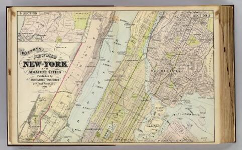
Map of New York and Adjacent Cities
from Atlas of the Hudson River Valley from New York city to Troy, including a section of about 8 miles in width. Published by Watson & co. Compiled from official records and careful surveys, under the supervision of F. W. Beers.
Central Harlem. (cont.)
From District 10
Topographical atlas of the city of New York, including the annexed territory showing original water courses and made land. / prepared under the direction of Egbert L. Viele.
From Topographical atlas of the city of New York, including the annexed territory showing original water courses and made land
Front Cover
from Height district map / City of New York, Board of Estimate and Apportionment.
New York City from 50th street to 127th street showing Central Park, Bloomingdale village, Yorkville, and the southern part of Harlem.
From Manhattan
West Side, Lincoln Square, Upper West Side. (cont.)
From District 7
City And County Of New - York North Of 50th St.
1 : 4800 Jones, R.A.
Outline and Index Map of Volume Four.
from Atlas of the city of New York, borough of Manhattan / from actual surveys and official plans by George W. and Walter S. Bromley.
Area District Map Section No. 5
from Area district map / City of New York, Board of Estimate and Apportionment.
Use District Map Section No. 5
from Use district map / City of New York, Board of Estimate and Apportionment.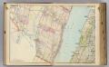
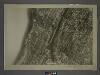
3 Bergen Co., N.J.
1 : 14400 Watson & Co. (New York, N.Y.)
Height District Map Section No. 5; Height district map / City of New York, Board of Estimate and Apportionment.
from Height district map / City of New York, Board of Estimate and Apportionment. New York (N.Y.). Board of Estimate and Apportionment,
TheWest End Plateau of the city of New York, 1879.
From Manhattan
Use District Map Section No. 6
from Use district map / City of New York, Board of Estimate and Apportionment.
64 Central Park Lots, New York City.
From Manhattan
New York N.
1 : 21120 Letts, Son & Co.
M-T-10-100: Index Map of Central Park, Boro. of Manhattan.
from Topographical survey of portion of Central Park, Boro. of Manhattan ... / City of New York, Department of Parks, Topographical Division.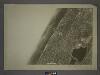
5D - N.Y. City (Aerial Set).
from Sectional aerial maps of the City of New York / [photographed and assembled under the direction of the chief engineer, July 1st, 1924].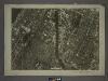
6A - N.Y. City (Aerial Set).
from Sectional aerial maps of the City of New York / [photographed and assembled under the direction of the chief engineer, July 1st, 1924].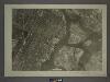
6C - N.Y. City (Aerial Set).
from Sectional aerial maps of the City of New York / [photographed and assembled under the direction of the chief engineer, July 1st, 1924].
5B - N.Y. City (Aerial Set).
from Sectional aerial maps of the City of New York / [photographed and assembled under the direction of the chief engineer, July 1st, 1924].
[Plan of Morningside Park.]
From Manhattan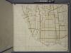
Bronx, Topographical Map Sheet 14; [Map bounded by 154th St., Grove St., Westchester Ave., Robbins Ave.; Including Powers Ave., Cypress Ave., Harlem River, 126th St., 6th Ave.]
From Topographical map made from surveys by the commissioners of the Department of Public Parks of the City of New York of that part of Westchester County adjacent to the City and County of New York embraced by chapter 534 of laws of 1871 as amended b...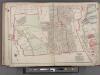
Bergen County, V. 1, Double Page Plate No. 1 [Map bounded by Edge Water Rd., Hudson River, Hudson County Blvd.] / by George W. and Walter S. Bromley.
From V. 1, 1912.
Sheet 18: [Bounded by 149th Street, (Harlem River,Bulk Head & Pier Lane), E. Hundred & Twenty Fourth Street.]
from Plan of New York City, from the Battery to Spuyten Duyvil Creek. Showing every lot and building thereon; old farm lines, strreet numbers at the corners of blocks, railroads, steamboat landings, bulkhead and pier lines, etc. Based on the surveys made by Messrs. Randall & Blackwell, and on the special survey by J. F. Harrison.
Sheet 16: [Bounded by E. Hundred & Twenty Fourth Street, 1st Avenue, E. Hundred & Twenty Second Street, Avenue A, E. Hundred & Twelfth Street, 1st Avenue, E. Ninety Second street and 5th Avenue.]
from Plan of New York City, from the Battery to Spuyten Duyvil Creek. Showing every lot and building thereon; old farm lines, strreet numbers at the corners of blocks, railroads, steamboat landings, bulkhead and pier lines, etc. Based on the surveys made by Messrs. Randall & Blackwell, and on the special survey by J. F. Harrison.
Sheet 17: [Bounded by 158th Street, 10th Avenue, 155th Street, 8th Avenue, 154th Street, 7th Avenue, 149th Street, 6th Avenue, W. Hundred & Twenty Fifth Street, and (Audubon Park) 11th Avenue.]
from Plan of New York City, from the Battery to Spuyten Duyvil Creek. Showing every lot and building thereon; old farm lines, strreet numbers at the corners of blocks, railroads, steamboat landings, bulkhead and pier lines, etc. Based on the surveys made by Messrs. Randall & Blackwell, and on the special survey by J. F. Harrison.
Sheet 15: [Bounded by [W. Hundred & Twenty Fourth Street], 6th Avenue, W. Hundred & Ninteenth Street, 5th Avenue, Central Park, [W. Ninety Second Street] and 12th Avenue.]
from Plan of New York City, from the Battery to Spuyten Duyvil Creek. Showing every lot and building thereon; old farm lines, strreet numbers at the corners of blocks, railroads, steamboat landings, bulkhead and pier lines, etc. Based on the surveys made by Messrs. Randall & Blackwell, and on the special survey by J. F. Harrison.