Maps of North Bergen

West Side, Lincoln Square, Upper West Side. (cont.)
From District 7
New York City from 50th street to 127th street showing Central Park, Bloomingdale village, Yorkville, and the southern part of Harlem.
From Manhattan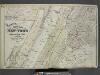
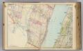
Map of New York and Adjacent Cities
from Atlas of the Hudson River Valley from New York city to Troy, including a section of about 8 miles in width. Published by Watson & co. Compiled from official records and careful surveys, under the supervision of F. W. Beers.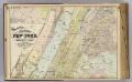
2 New York, etc.
1 : 18300 Watson, Gaylord
From New York to Stratford. (1)
1 : 35000 Colles, Christopher
Central Harlem. (cont.)
From District 10
Topographical atlas of the city of New York, including the annexed territory showing original water courses and made land. / prepared under the direction of Egbert L. Viele.
From Topographical atlas of the city of New York, including the annexed territory showing original water courses and made land
Nostrands map of New York house numbers and subway guide. Ohman Map Co.
1 : 16000 Nostrand, George J.
Key
From Atlas 141. Vol. 5, 1903.
Area District Map Section No. 5
from Area district map / City of New York, Board of Estimate and Apportionment.
Use District Map Section No. 5
from Use district map / City of New York, Board of Estimate and Apportionment.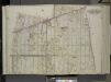
Queens, Vol. 2, Double Page Plate No. 9; Part of Long Island City Ward One (Part of Old Wards 4 and 5); [Map bounded by Woolsey Ave., Albert St., Potter Ave.; Including Old Bowery Bay Road, Jamaica Ave., Debevoise Ave.]
from First and second wards: Long Island City and Newtown.
Topographical atlas of the city of New York, including the annexed territory showing original water courses and made land. / prepared under the direction of Egbert L. Viele.
From Topographical atlas of the city of New York, including the annexed territory showing original water courses and made land
64 Central Park Lots, New York City.
From Manhattan
M-T-10-100: Index Map of Central Park, Boro. of Manhattan.
from Topographical survey of portion of Central Park, Boro. of Manhattan ... / City of New York, Department of Parks, Topographical Division.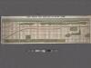
TheWest End Plateau of the city of New York, 1879.
From Manhattan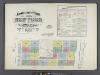
Insurance maps of the City of New York. Surveyed and published by Sanborn-Perris Map Co., Limited. 115 Broadway, 1892. Volume 6. / Key
From Atlas 117. Vol. 6, 1892.
Use District Map Section No. 8
from Use district map / City of New York, Board of Estimate and Apportionment.
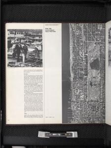
[Map of that part of New York City Between 34th St. and 46th St., and the East and Hudson Rivers, showing] encroachment of nuisances upon populous up-town districts.
From Manhattan
Area District Map Section No. 8
from Area district map / City of New York, Board of Estimate and Apportionment.
Front Cover
from Height district map / City of New York, Board of Estimate and Apportionment.
Part of Section 4 : Plate 80.
from Atlas of the borough of Manhattan, city of New York.
Height District Map Section No. 8
from Height district map / City of New York, Board of Estimate and Apportionment.
New York N.
1 : 21120 Letts, Son & Co.
City And County Of New - York North Of 50th St.
1 : 4800 Jones, R.A.
Outline and Index Map of Atlas of New York City.
from Atlas of the borough of Manhattan, city of New York.
Map of the lands included in the Central Park, from a topographical survey, June 17th, 1856; [Also:] Plan for the improvement of the Central Park, adopted by the Commissioners, June 3rd, 1856.
from Manhattan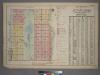
Outline and Index Map of Atlas of New York City, Borough of Manhattan. 59th St. to 110th Street. Street Index.
from Atlas of the city of New York, borough of Manhattan. From actual surveys and official plans / by George W. and Walter S. Bromley.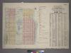
Outline & Index Map of Volume One, Atlas of New York City, Borough of Manhattan : 59th Street to 110th Street.
from Atlas of the city of New York, borough of Manhattan. From actual surveys and official plans / by George W. and Walter S. Bromley.