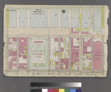
Maps of North Bergen

Part of Section 4 : Plate 80.
from Atlas of the borough of Manhattan, city of New York.
Height District Map Section No. 5; Height district map / City of New York, Board of Estimate and Apportionment.
from Height district map / City of New York, Board of Estimate and Apportionment. New York (N.Y.). Board of Estimate and Apportionment,
8A - N.Y. City (Aerial Set).
from Sectional aerial maps of the City of New York / [photographed and assembled under the direction of the chief engineer, July 1st, 1924].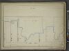
[Map bounded by Pier - Line, W. 61st St, Eleventh Avenue, W. 53th St; Including Twelfth Avenue, W. 54th St, W. 55th St, W. 56th St, W. 57th St, W. 58th St, W. 59st St, W. 60nd St]
from Maps of the wharves & piers from the Battery to 61st street on the Hudson river and from the Battery to 41st street on the East river, New York. Surveyed by I.C. Buckhout, city surveyor.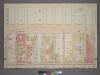
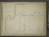
Plate 40, Part of Section 4: [Bounded by Twelfth Avenue (Hudson River Piers), W. 59th Street, Eleventh Avenue and W. 50th Street.]
from Atlas of the city of New York, borough of Manhattan. From actual surveys and official plans / by George W. and Walter S. Bromley.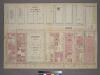
Plate 40, Part of Section 4: [Bounded by Twelfth Avenue (Hudson River Piers), W. 59th Street, Eleventh Avenue and W. 50th Street.]
from Atlas of the city of New York, borough of Manhattan. From actual surveys and official plans / by George W. and Walter S. Bromley.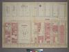
Plate 40, Part of Section 4: [Bounded by Twelfth Avenue (Hudson River Piers), W. 59th Street, Eleventh Avenue and W. 59th Street.]
from Atlas of the city of New York, borough of Manhattan. From actual surveys and official plans / by George W. and Walter S. Bromley.
Manhattan, V. 5, Plate No. 50 [Map bounded by Hudson River, West 52nd St., 11th Ave., West 49th St.]
From Atlas 116.1. Vol. 5, 1911.
Plate 103: Map bounded by West 57th Street, Tenth Avenue, West 52nd Steet, Hudson River
from Maps of the city of New York.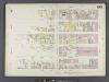
Manhattan, V. 6, Double Page Plate No. 103 [Map bounded by W. 57th St., 10th Ave., W. 52nd St., 12th Ave.]
From Atlas 117. Vol. 6, 1892.
West Side, Lincoln Square, Upper West Side. (cont.)
From District 7
Area District Map Section No. 5
from Area district map / City of New York, Board of Estimate and Apportionment.
Use District Map Section No. 5
from Use district map / City of New York, Board of Estimate and Apportionment.
Weehawken
1 : 24000
Weehawken
1 : 24000
Weehawken
1 : 24000
Weehawken
1 : 24000
Weehawken
1 : 25000
Weehawken
1 : 25000
Weehawken
1 : 31680
Weehawken
1 : 31680
Weehawken
1 : 24000
Queens, Vol. 2, Double Page Plate No. 9; Part of Long Island City Ward One (Part of Old Wards 4 and 5); [Map bounded by Woolsey Ave., Albert St., Potter Ave.; Including Old Bowery Bay Road, Jamaica Ave., Debevoise Ave.]
from First and second wards: Long Island City and Newtown.
Map of Brookland Ferry. Extracted from: Stiles, Henry Reed. A History of the city of brooklyn. V.1.
From Brooklyn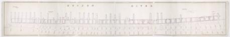
[Map of wharves and piers on North River from Battery Place to Hammond Street] / Edwin Smith, city surveyor, New York, November 1850.
from Manhattan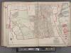
Bergen County, V. 1, Double Page Plate No. 1 [Map bounded by Edge Water Rd., Hudson River, Hudson County Blvd.] / by George W. and Walter S. Bromley.
From V. 1, 1912.
Plan of Weehawken township.
from Combined atlas of the State of New Jersey and the County of Hudson : from actual survey, official records & private plans / by and under the direction of G. M. Hopkins ...
Plan of Weehawken Township.
1 : 9600 Hopkins, G.M.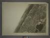
5D - N.Y. City (Aerial Set).
from Sectional aerial maps of the City of New York / [photographed and assembled under the direction of the chief engineer, July 1st, 1924].