Maps of Union City

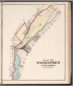
Plan of Weehawken Township.
1 : 9600 Hopkins, G.M.
Plan of Weehawken township.
from Combined atlas of the State of New Jersey and the County of Hudson : from actual survey, official records & private plans / by and under the direction of G. M. Hopkins ...
8A - N.Y. City (Aerial Set).
from Sectional aerial maps of the City of New York / [photographed and assembled under the direction of the chief engineer, July 1st, 1924].
8C - N.Y. City (Aerial Set).
from Sectional aerial maps of the City of New York / [photographed and assembled under the direction of the chief engineer, July 1st, 1924].
Map of the city of New-York extending northward to Fiftieth St. / surveyed and drawn by John F. Harrison, C.E.
from Manhattan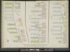
Manhattan, V. 5, Double Page Plate [Map bounded by Hudson River, 13th Ave., 12th Ave.]
From Atlas 42.55. Vol. 5, 1890.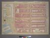
Plate 7, Part of Section 3: [Bounded by W. 26th Street, Ninth Avenue (Chelsea Square), W. 20th Street, 13th Street, W. 23rd Street and Eleventh Avenue.]
from Atlas of the city of New York, borough of Manhattan. From actual surveys and official plans / by George W. and Walter S. Bromley.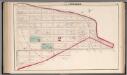
Hoboken - Plate E.
Hopkins, G.M.
Part of Sections 3 , & 5 : Plate 69
from Atlas of the borough of Manhattan, city of New York.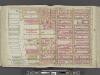
Manhattan, Double Page Plate No. 18 [Map bounded by W. 36th St., 8th Ave., W. 25th St., Hudson River]
From Atlas of the city of New York, Manhattan Island. From actual surveys and official plans
Part of Section 3 : New York City.
from Atlas of the city of New York, Manhattan Island. From actual surveys and official plans / by George W. and Walter S. Bromley.
[Plate 18: Bounded by W. 36th Street, Eighth Avenue, W. 25th Street, Thirteenth Avenue, [Hudson River, Piers 55-60], and [Hudson River, Piers 61-66], Twelfth Avenue.]
from Atlas of the city of New York, borough of Manhattan. From actual surveys and official plans / by George W. and Walter S. Bromley.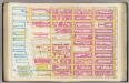
Pl. 18: wards 16, 20.
1 : 1800 Bromley, George Washington; Bromley, Walter Scott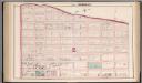
Hoboken - Plate C.
Hopkins, G.M.
[Plate 14: Bounded by W. 40th Street, Sixth Avenue, W. 27th Street and Twelfth Avenue.]
from Atlas of the city of New York : embracing all territory within its corporate limits from official records, private plans & actual surveys / by and under the supervision of E. Robinson & R.H. Pidgeon, civil engineers.
Part of Section 2 : New York City.
from Atlas of the city of New York, Manhattan Island. From actual surveys and official plans / by George W. and Walter S. Bromley.
Plate 13: Bounded by W. 25th Street, Seventh Avenue, W. 14th Street, [Hudson River, Pierhead Line, Piers 57-62], and Thirteenth Avenue.]
from Atlas of the city of New York, borough of Manhattan. From actual surveys and official plans / by George W. and Walter S. Bromley.
Manhattan, Double Page Plate No. 13 [Map bounded by W. 25th St., 7th Ave., W. 14th St., Hudson River]
From Atlas of the city of New York, Manhattan Island. From actual surveys and official plans
Manhattan, Double Page Plate No. 19 [Map bounded by W. 47th St., 8th Ave., W. 36th St., Hudson River]
From Atlas of the city of New York, Manhattan Island. From actual surveys and official plans
Plate 19: Bounded by W. 47th Street, Eighth Avenue, W. 36th Street and (Hudson River, Piers 66-77) Twelfth Avenue.
from Atlas of the city of New York, Manhattan Island. From actual surveys and official plans / by George W. and Walter S. Bromley.
Part of Sections 3 & 4 : New York City.
from Atlas of the city of New York, borough of Manhattan. From actual surveys and official plans / by George W. and Walter S. Bromley.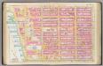
Pl. 13: ward 16.
1 : 1800 Bromley, George Washington; Bromley, Walter Scott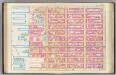
Pl. 19: wards 20, 22.
1 : 1800 Bromley, George Washington; Bromley, Walter Scott
Part of Section 3 : Plate47.
from Atlas of the borough of Manhattan, city of New York.
[Plate 52: Bounded by Hudson River [Piers 63-72], W. 32nd Street, Eleventh Avenue and 32nd Street.]
from Atlas of the borough of Manhattan, city of New York.
Part of Section 3 : Plate 53.
from Atlas of the borough of Manhattan, city of New York.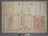
Plate 18, Part of Sections 3&4: [Bounded by (Hudson River Piers)Twelfth Avenue, W. 41st Street, Eleventh Avenue and W. 34th Street.
from Atlas of the city of New York, borough of Manhattan. From actual surveys and official plans / by George W. and Walter S. Bromley.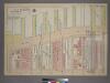
Plate 17, Part of Section 3: [Bounded by W. 32nd Street, Eleventh Avenue, W. 23rd Street and (Hudson River Piers) Thirteenth Avenue.]
from Atlas of the city of New York, borough of Manhattan. From actual surveys and official plans / by George W. and Walter S. Bromley.
Plate 16, Part of Section 3: [Bounded by W. 32nd Street, Ninth Avenue, W. 26th Street and Eleventh Avenue.]
from Atlas of the city of New York, borough of Manhattan. From actual surveys and official plans / by George W. and Walter S. Bromley.