Maps of Guttenberg
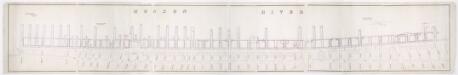
[Map of wharves and piers on North River from Battery Place to Hammond Street] / Edwin Smith, city surveyor, New York, November 1850.
from Manhattan
Key
From Atlas 42.53. Vol. 3, 1895.
Map of the city of New-York extending northward to Fiftieth St. / surveyed and drawn by John F. Harrison, C.E.
from Manhattan
Map of the city of New-York extending northward to Fiftieth St. / surveyed and drawn by John F. Harrison, C.E.
from Manhattan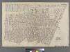
[Plate 10: Bounded by West Street (Hudson River, Piers 39-47), W. 11th Street, 13th Avenue (Hudson River, Piers [52?]-59), W. 14th Street, 7th Avenue, Greenwich Avenue, Perry Street, Waverly Place, Christopher Street, W. 4th Street, 6th Avenue, Bleecker
from Atlas of the city of New York : embracing all territory within its corporate limits from official records, private plans & actual surveys / by and under the supervision of E. Robinson & R.H. Pidgeon, civil engineers.
Part of Section 2 : New York City.
from Atlas of the city of New York, Manhattan Island. From actual surveys and official plans / by George W. and Walter S. Bromley.
Manhattan, V. 1, Plate No. 71 [Map bounded by W. Houston St., Wooster St., Spring St., Sullivan St.]
From Atlas 108. Vol. 1, [1903?].
Plate 13: Bounded by W. 25th Street, Seventh Avenue, W. 14th Street, [Hudson River, Pierhead Line, Piers 57-62], and Thirteenth Avenue.]
from Atlas of the city of New York, borough of Manhattan. From actual surveys and official plans / by George W. and Walter S. Bromley.
Manhattan, Double Page Plate No. 13 [Map bounded by W. 25th St., 7th Ave., W. 14th St., Hudson River]
From Atlas of the city of New York, Manhattan Island. From actual surveys and official plans
Manhattan, V. 5, Double Page Plate [Map bounded by Hudson River, 13th Ave., 12th Ave.]
From Atlas 42.55. Vol. 5, 1890.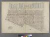
Part of Wards 5 & 8, New York City.
from Atlas of the city of New York : embracing all territory within its corporate limits from official records, private plans & actual surveys / by and under the supervision of E. Robinson & R.H. Pidgeon, civil engineers.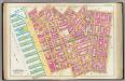
Pl. 9: wards 8-9 & 15.
1 : 1800 Bromley, George Washington; Bromley, Walter Scott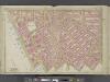
Manhattan, Double Page Plate No. 10 [Map bounded by W. 14th St., 6th Ave., Bedford St., Hudson River]
From Atlas of the city of New York, Manhattan Island. From actual surveys and official plans
A view of Collect Pond and its vicinity in the City of New York in 1793 : on which pond the first boat propelled by paddle wheels and screw-propellers constructed by John Fitch, six years before Robert Fulton ... / by John Hutchings ; drawn & lith. b
from Manhattan
[Plate 10: Bounded by W. 14th Street, Sixth Avenue, Cornelia Street, Bleecker Street, Barrow Street, Bedford Street, Christopher Street, Hudson Street, W. 10th Street, Washington Street, Charles Street, and [Hudson River, Piers 48-55] West Street.]
from Atlas of the city of New York, borough of Manhattan. From actual surveys and official plans / by George W. and Walter S. Bromley.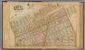
3. Wards 5, 8.
1 : 2400 G.W. Bromley & Co.; Geo. W. Bromley & E. Robinson
Plate 9: Bounded by Charles Street, Washington Street, W. 10th Street, Hudson Street, Christopher Street, Bedford Street, Barrow Street, Bleecker Street, Cornelia Street, Sixth Avenue, W. 3rd Street, W. Broadway, Broome Street, Hudson Street, Spring Stre
from Atlas of the city of New York, Manhattan Island. From actual surveys and official plans / by George W. and Walter S. Bromley.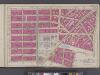
Manhattan, V. 4, Double Page Plate No. 5 [Map bounded by Worth St., New Bowery, Pearl St., Cold St., Beekman St., Barclay St., College Place, West Broadway]
From Vol. 4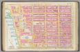
Pl. 13: ward 16.
1 : 1800 Bromley, George Washington; Bromley, Walter Scott
[Plate 10: Bounded by W. 14th Street, Sixth Avenue, Cornelia Street, Bleecker Street, Barrow Street, Bedford Street, Christopher Street, Hudson Street, W. 10th Street, Washington Street, Charles Street, West Street (Hudson River, ???), Gansevoort Street,
from Atlas of the city of New York, Manhattan Island. From actual surveys and official plans / by George W. and Walter S. Bromley.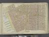
Manhattan, Double Page Plate No. 4 [Map bounded by Spring St., Broome St., Centre St., Pearl St., Thomas St., Jay St., Hudson River]
From Atlas of the city of New York, Manhattan Island. From actual surveys and official plans
Part of Sections 1 & 2 : New York City.
from Atlas of the city of New York, Manhattan Island. From actual surveys and official plans / by George W. and Walter S. Bromley.
Page 1: [Bounded by W. 19th Street, Seventh Avenue, Greenwich Lane or Great-Kill Road and North River.]
from Maps of farms commonly called the Blue book, 1815 : drawn from the original on file in the street commissioner's office in the City of New York, together with lines of streets and avenues / laid out by John Randel, jr., 1819-20.
[Plate 9: Bounded by Charles Street, Washington Street, W. 10th Street, Hudson Street, Christopher Street, Bedford Street, Barrow Street, Bleecker Street, Cornelia Street, Sixth Avenue, W. 3rd Street, W. Broadway, Broome Street, Hudson Street, Spring Str
from Atlas of the city of New York, borough of Manhattan. From actual surveys and official plans / by George W. and Walter S. Bromley.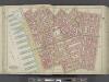
Manhattan, Double Page Plate No. 9 [Map bounded by Charles St., W. 3rd St., S. 5th Ave., Broome St., Hudson River]
From Atlas of the city of New York, Manhattan Island. From actual surveys and official plans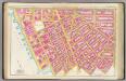
Pl. 10: ward 9.
1 : 1800 Bromley, George Washington; Bromley, Walter Scott
Part of Wards 16 &20, New York City.
from Atlas of the city of New York : embracing all territory within its corporate limits from official records, private plans & actual surveys / by and under the supervision of E. Robinson & R.H. Pidgeon, civil engineers.
[Plate 4: Bounded by Spring Street, Hudson Street, Broome Street, Centre Street, Pearl Street, Thomas Street, Hudson Street, Jay Sreet and [Hudson River, Piers 22-34] West Street.]
from Atlas of the city of New York, borough of Manhattan. From actual surveys and official plans / by George W. and Walter S. Bromley.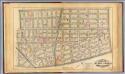
4. Wards 5-6, 8, 14.
1 : 2400 G.W. Bromley & Co.; Geo. W. Bromley & E. Robinson
![[Map of wharves and piers on North River from Battery Place to Hammond Street] / Edwin Smith, city surveyor, New York, November 1850.](https://images-2.georeferencer.com/images/iiif/935132728497/full/,300/0/native.jpg)

