Maps of Manhattan Community Board 9

New York City from 50th street to 127th street showing Central Park, Bloomingdale village, Yorkville, and the southern part of Harlem.
From Manhattan
Key
From Atlas 141. Vol. 5, 1903.
Topographical atlas of the city of New York, including the annexed territory showing original water courses and made land. / prepared under the direction of Egbert L. Viele.
From Topographical atlas of the city of New York, including the annexed territory showing original water courses and made land
Outline and Index Map of Atlas of New York City.
from Atlas of the borough of Manhattan, city of New York.
Insurance maps of the City of New York. Surveyed and published by Sanborn-Perris Map Co., Limited. 115 Broadway, 1892. Volume 6. / Key
From Atlas 117. Vol. 6, 1892.
Outline and Index Map of Atlas of New York City, Borough of Manhattan. 59th St. to 110th Street. Street Index.
from Atlas of the city of New York, borough of Manhattan. From actual surveys and official plans / by George W. and Walter S. Bromley.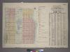
Outline & Index Map of Volume One, Atlas of New York City, Borough of Manhattan : 59th Street to 110th Street.
from Atlas of the city of New York, borough of Manhattan. From actual surveys and official plans / by George W. and Walter S. Bromley.
Central Harlem. (cont.)
From District 10
West Side, Lincoln Square, Upper West Side. (cont.)
From District 7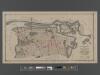
[Long Island City, Queens] Record of searches in relation to the legal status of avenues and streets in the 1st Ward of the Borough of Queens.
From Queens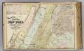
2 New York, etc.
1 : 18300 Watson, Gaylord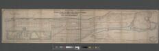
Map of the Upper Part of New York from 57th St. to Kingsbridge showing the "West Side Improvements," with dimensions, elevations of grade, & distances complete.
From Manhattan
Front Cover
from Height district map / City of New York, Board of Estimate and Apportionment.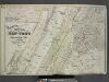
Map of New York and Adjacent Cities
from Atlas of the Hudson River Valley from New York city to Troy, including a section of about 8 miles in width. Published by Watson & co. Compiled from official records and careful surveys, under the supervision of F. W. Beers.
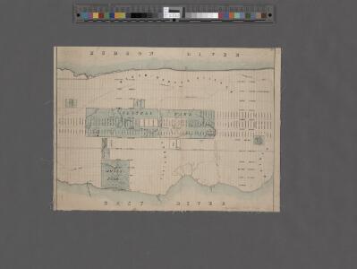
Map of the Harlem River and Spuyten Duyvil Creek from Ward's Island to the Hudson River, showing project for a covered waterway 60 feet wide to be built on the west line of the Harlem River from the easterly side of Third Avenue to 165th street, New Y...
From Manhattan
Central Park
1 : 24000
Central Park
1 : 24000
Central Park
1 : 24000
Central Park
1 : 24000
Central Park
1 : 24000
Central Park
1 : 24000
Central Park
1 : 24000
Central Park
1 : 24000
From New York to Stratford. (1)
1 : 35000 Colles, Christopher
Nostrands map of New York house numbers and subway guide. Ohman Map Co.
1 : 16000 Nostrand, George J.
City And County Of New - York North Of 50th St.
1 : 4800 Jones, R.A.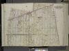
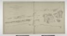
Queens, Vol. 2, Double Page Plate No. 9; Part of Long Island City Ward One (Part of Old Wards 4 and 5); [Map bounded by Woolsey Ave., Albert St., Potter Ave.; Including Old Bowery Bay Road, Jamaica Ave., Debevoise Ave.]
from First and second wards: Long Island City and Newtown.
Topographical atlas of the city of New York, including the annexed territory showing original water courses and made land. / prepared under the direction of Egbert L. Viele.
From Topographical atlas of the city of New York, including the annexed territory showing original water courses and made land
New York N.
1 : 21120 Letts, Son & Co.