Maps of Guttenberg

M-T-10-100: Index Map of Central Park, Boro. of Manhattan.
from Topographical survey of portion of Central Park, Boro. of Manhattan ... / City of New York, Department of Parks, Topographical Division.
New York N.
1 : 21120 Letts, Son & Co.
64 Central Park Lots, New York City.
From Manhattan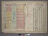
Outline and Index Map of Atlas of New York City, Borough of Manhattan. 59th St. to 110th Street. Street Index.
from Atlas of the city of New York, borough of Manhattan. From actual surveys and official plans / by George W. and Walter S. Bromley.
Outline & Index Map of Volume One, Atlas of New York City, Borough of Manhattan : 59th Street to 110th Street.
from Atlas of the city of New York, borough of Manhattan. From actual surveys and official plans / by George W. and Walter S. Bromley.
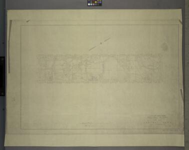
TheWest End Plateau of the city of New York, 1879.
From Manhattan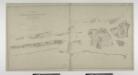
Blackwell's, Ward's and Randall's islands and adjacent shores of East and Harlem Rivers : from 51st St. New York to Lawrence's Pt. / U.S. Coast and Geodetic Survey, F.M. Thorn, superintendent ; surveyed by E. Hergesheimer, assistant, 1885.
from New York harbor
Data for population from census of 1910, Borough of Manhattan
From Manhattan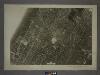
8B - N.Y. City (Aerial Set).
from Sectional aerial maps of the City of New York / [photographed and assembled under the direction of the chief engineer, July 1st, 1924].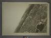
5D - N.Y. City (Aerial Set).
from Sectional aerial maps of the City of New York / [photographed and assembled under the direction of the chief engineer, July 1st, 1924].
Sheet 16: [Bounded by E. Hundred & Twenty Fourth Street, 1st Avenue, E. Hundred & Twenty Second Street, Avenue A, E. Hundred & Twelfth Street, 1st Avenue, E. Ninety Second street and 5th Avenue.]
from Plan of New York City, from the Battery to Spuyten Duyvil Creek. Showing every lot and building thereon; old farm lines, strreet numbers at the corners of blocks, railroads, steamboat landings, bulkhead and pier lines, etc. Based on the surveys made by Messrs. Randall & Blackwell, and on the special survey by J. F. Harrison.
Sheet 14: [Bounded by E. Ninety Second Street, Avenue A, E. Nintieth Street, Avenue B, E. Seventy Second Street, Avenue A, [E. Fifty Ninth Street] and 5th Avenue.]
from Plan of New York City, from the Battery to Spuyten Duyvil Creek. Showing every lot and building thereon; old farm lines, strreet numbers at the corners of blocks, railroads, steamboat landings, bulkhead and pier lines, etc. Based on the surveys made by Messrs. Randall & Blackwell, and on the special survey by J. F. Harrison.
Sheet 13: [Bounded by W. Ninty First Street, (New Reservoir) 5th Avenue, Fifty Ninth Street and 12th Avenue.]
from Plan of New York City, from the Battery to Spuyten Duyvil Creek. Showing every lot and building thereon; old farm lines, strreet numbers at the corners of blocks, railroads, steamboat landings, bulkhead and pier lines, etc. Based on the surveys made by Messrs. Randall & Blackwell, and on the special survey by J. F. Harrison.
Sheet 15: [Bounded by [W. Hundred & Twenty Fourth Street], 6th Avenue, W. Hundred & Ninteenth Street, 5th Avenue, Central Park, [W. Ninety Second Street] and 12th Avenue.]
from Plan of New York City, from the Battery to Spuyten Duyvil Creek. Showing every lot and building thereon; old farm lines, strreet numbers at the corners of blocks, railroads, steamboat landings, bulkhead and pier lines, etc. Based on the surveys made by Messrs. Randall & Blackwell, and on the special survey by J. F. Harrison.
Central Park
From Manhattan
Manhattan V. 7, Plate No. 55 [Map bounded by Columbus Ave., Cathedral Parkway, Central Park West, W. 108th St.]
From Atlas 121. Vol. 7, pt. 1, 1912.
Central Park
from Manhattan
Sheet 11: [Bounded by Fifty Ninth Street, Seventh Avenue, W. Fortieth Street and Thirteenth Avenue.]
from Plan of New York City, from the Battery to Spuyten Duyvil Creek. Showing every lot and building thereon; old farm lines, strreet numbers at the corners of blocks, railroads, steamboat landings, bulkhead and pier lines, etc. Based on the surveys made by Messrs. Randall & Blackwell, and on the special survey by J. F. Harrison.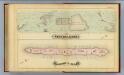
41. Central Park, Blackwells Island.
1 : 6000 G.W. Bromley & Co.; Geo. W. Bromley & E. Robinson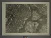
6C - N.Y. City (Aerial Set).
from Sectional aerial maps of the City of New York / [photographed and assembled under the direction of the chief engineer, July 1st, 1924].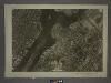
9A - N.Y. City (Aerial Set).
from Sectional aerial maps of the City of New York / [photographed and assembled under the direction of the chief engineer, July 1st, 1924].
Sackersdorff Farm Set.
from Maps of farms commonly called the Blue book, 1815 : drawn from the original on file in the street commissioner's office in the City of New York, together with lines of streets and avenues / laid out by John Randel, jr., 1819-20.
[Plate 22: Bounded by Sixth Avenue, Central Park South, Fifth Avenue, E. 64th Street, Lexington Avenue, and E. 47th Street.]
from Atlas of the city of New York, borough of Manhattan. From actual surveys and official plans / by George W. and Walter S. Bromley.
Map showing the high and low water mark and the original city grants of lands under water made to various parties from 1686 to 1873, extending from Battery to Fifty-first Street, Hudson and East Rivers, New York City, also the several pier and bulkhead l
from Whole
Sackersdorff Farm set.
from Maps of farms commonly called the Blue book, 1815 : drawn from the original on file in the street commissioner's office in the City of New York, together with lines of streets and avenues / laid out by John Randel, jr., 1819-20.
Sackersdorff Farm Set.
from Sackersdorf Farm Set.
Page 16: [Bounded by W. 114th Street, Fourth (Park) Avenue, (Spanish Harlem) E. 94th Street (Carnegie Hill) and Eighth Avenue.]
from Sackersdorf Farm Set.
Page 8: [Bounded by W. 57th Street, Eighth Avenue (Fashion Center), W. 37th Street and Hudson River.]
from Sackersdorf Farm Set.
Sackersdorff Farm set.
from Maps of farms commonly called the Blue book, 1815 : drawn from the original on file in the street commissioner's office in the City of New York, together with lines of streets and avenues / laid out by John Randel, jr., 1819-20.