Maps of Manhattan Community Board 9
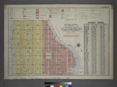
Outline and Index Map of Volume Four.
from Atlas of the city of New York, borough of Manhattan / from actual surveys and official plans by George W. and Walter S. Bromley.
Use District Map Section No. 6
from Use district map / City of New York, Board of Estimate and Apportionment.
Area District Map Section No. 6; Area district map / City of New York, Board of Estimate and Apportionment.
from Area district map / City of New York, Board of Estimate and Apportionment. New York (N.Y.). Board of Estimate and Apportionment,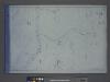
Height District Map Section No. 6; Height district map / City of New York, Board of Estimate and Apportionment.
from Height district map / City of New York, Board of Estimate and Apportionment. New York (N.Y.). Board of Estimate and Apportionment,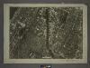
6A - N.Y. City (Aerial Set).
from Sectional aerial maps of the City of New York / [photographed and assembled under the direction of the chief engineer, July 1st, 1924].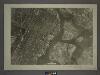
6C - N.Y. City (Aerial Set).
from Sectional aerial maps of the City of New York / [photographed and assembled under the direction of the chief engineer, July 1st, 1924].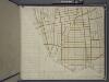
Bronx, Topographical Map Sheet 14; [Map bounded by 154th St., Grove St., Westchester Ave., Robbins Ave.; Including Powers Ave., Cypress Ave., Harlem River, 126th St., 6th Ave.]
From Topographical map made from surveys by the commissioners of the Department of Public Parks of the City of New York of that part of Westchester County adjacent to the City and County of New York embraced by chapter 534 of laws of 1871 as amended b...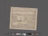
[Plan of Morningside Park.]
From Manhattan
Sheet 18: [Bounded by 149th Street, (Harlem River,Bulk Head & Pier Lane), E. Hundred & Twenty Fourth Street.]
from Plan of New York City, from the Battery to Spuyten Duyvil Creek. Showing every lot and building thereon; old farm lines, strreet numbers at the corners of blocks, railroads, steamboat landings, bulkhead and pier lines, etc. Based on the surveys made by Messrs. Randall & Blackwell, and on the special survey by J. F. Harrison.
Sheet 16: [Bounded by E. Hundred & Twenty Fourth Street, 1st Avenue, E. Hundred & Twenty Second Street, Avenue A, E. Hundred & Twelfth Street, 1st Avenue, E. Ninety Second street and 5th Avenue.]
from Plan of New York City, from the Battery to Spuyten Duyvil Creek. Showing every lot and building thereon; old farm lines, strreet numbers at the corners of blocks, railroads, steamboat landings, bulkhead and pier lines, etc. Based on the surveys made by Messrs. Randall & Blackwell, and on the special survey by J. F. Harrison.
Sheet 17: [Bounded by 158th Street, 10th Avenue, 155th Street, 8th Avenue, 154th Street, 7th Avenue, 149th Street, 6th Avenue, W. Hundred & Twenty Fifth Street, and (Audubon Park) 11th Avenue.]
from Plan of New York City, from the Battery to Spuyten Duyvil Creek. Showing every lot and building thereon; old farm lines, strreet numbers at the corners of blocks, railroads, steamboat landings, bulkhead and pier lines, etc. Based on the surveys made by Messrs. Randall & Blackwell, and on the special survey by J. F. Harrison.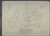
Hell Gate and its approaches / from a trigonometrical survey under the direction of F.R. Hassler and A.D. Bache, superintendents of the Survey of the Coast of the United States.
from New York harbor
Hell Gate & approaches.
1 : 5000 Hassler, F. R.
Sheet 15: [Bounded by [W. Hundred & Twenty Fourth Street], 6th Avenue, W. Hundred & Ninteenth Street, 5th Avenue, Central Park, [W. Ninety Second Street] and 12th Avenue.]
from Plan of New York City, from the Battery to Spuyten Duyvil Creek. Showing every lot and building thereon; old farm lines, strreet numbers at the corners of blocks, railroads, steamboat landings, bulkhead and pier lines, etc. Based on the surveys made by Messrs. Randall & Blackwell, and on the special survey by J. F. Harrison.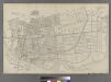
Part of Ward 23, New York City.
from Atlas of the city of New York : embracing all territory within its corporate limits from official records, private plans & actual surveys / by and under the supervision of E. Robinson & R.H. Pidgeon, civil engineers.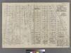
Part of Ward 12, New York City.
from Atlas of the city of New York : embracing all territory within its corporate limits from official records, private plans & actual surveys / by and under the supervision of E. Robinson & R.H. Pidgeon, civil engineers.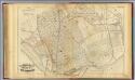
34. Ward 23.
1 : 4800 G.W. Bromley & Co.; Geo. W. Bromley & E. Robinson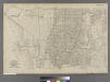
Part of Ward 23, New York City.
from Atlas of the city of New York : embracing all territory within its corporate limits from official records, private plans & actual surveys / by and under the supervision of E. Robinson & R.H. Pidgeon, civil engineers.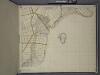
Bronx, Topographical Map Sheet 15; [Map bounded by 151 St., Southern Blvd., 149th St., Whitlock Ave., Wetmore Ave.; Including Edgewater Road, Cypress Ave., Powers Ave., Robbins Ave.]
From Topographical map made from surveys by the commissioners of the Department of Public Parks of the City of New York of that part of Westchester County adjacent to the City and County of New York embraced by chapter 534 of laws of 1871 as amended b...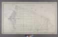
Section 1 of Final Maps and Profiles, of the 23rd & 24th Wards.
from Maps or plans and profiles, with field notes and explanatory remarks, showing the location, width, grades, and class of streets, roads, avenues, public squares and places, located and laid out by the Commissioner of Street Improvements of the 23rd and 24th wards of the city of New York : under authority of Chapter 545 of the laws of 1890.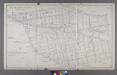
Map or Plan of Section 6. [Bounded by Courtlandt Avenue, New York and Harlem Railroad, E. 168th Street, Prospect Avenue and Westchester Avenue.]
from Maps or plans and profiles, with field notes and explanatory remarks, showing the location, width, grades, and class of streets, roads, avenues, public squares and places, located and laid out by the Commissioner of Street Improvements of the 23rd and 24th wards of the city of New York : under authority of Chapter 545 of the laws of 1890.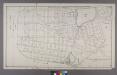
Section 1: Map or Plan of Section 2.[Bounded by St. Ann's Avenue, Westchester Avenue, Robbins Avenue, E. 149th Street, Whitlock Avenue, E. 141st Street, Locust Avenue, E. 131st Street and E. 130th Street.]
from Maps or plans and profiles, with field notes and explanatory remarks, showing the location, width, grades, and class of streets, roads, avenues, public squares and places, located and laid out by the Commissioner of Street Improvements of the 23rd and 24th wards of the city of New York : under authority of Chapter 545 of the laws of 1890.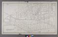
Section 7 of Final Maps and Profiles, of the 23rd & 24th Wards.
from Maps or plans and profiles, with field notes and explanatory remarks, showing the location, width, grades, and class of streets, roads, avenues, public squares and places, located and laid out by the Commissioner of Street Improvements of the 23rd and 24th wards of the city of New York : under authority of Chapter 545 of the laws of 1890.
Plate 4: Map No. 302 [Bounded by Harlem River, [149th Street] and Post Road from New York to Boston.]- Map No. 549 [Bounded by Grove St., Cottage St., Villa Place, Old Boston Road, 130th Street, 4th Avenue, Macomb Avenue and Walton Avenue.]
from Certified copies of important maps appertaining to the 23rd and 24th wards, City of New York, filed in the Register's office at White Plains, County of Westchester, New York ...
Plate 16: Map No. 17 [Bounded by Third Avenue, First Street, East River and Eleventh Street.]
from Certified copies of important maps appertaining to the 23rd and 24th wards, City of New York, filed in the Register's office at White Plains, County of Westchester, New York ...
Plate 5: Map No. 375 [Bounded by Fourth Avenue, Riverside Avenue, Macomb Avenue, Cottage Street, Morris Avenue, 3rd Avenue and 129th Street.] - Map No. 213 [Bounded by Cherry Street, Old Harlem Bridge Post Road from New York to Boston, Harlem River and N
from Certified copies of important maps appertaining to the 23rd and 24th wards, City of New York, filed in the Register's office at White Plains, County of Westchester, New York ...
Plate 18: Vol. 4 of Maps, Page 34 [Bounded by 138th Street, St.Ann's Avenue, 131st Street and Willis Avenue.] - Map No. 41: [Bounded by Hunt Point Road North Place, Bronx River and Long Island Sound.]
from Certified copies of important maps appertaining to the 23rd and 24th wards, City of New York, filed in the Register's office at White Plains, County of Westchester, New York ...
Plate 6: Map No. 141 [Bounded by James Street, (Wm. Morris Farm), Rail Road Avenue, Prospect Street, Juliet Street, Gerard Street, Henry Street and River Avenue.]- Map No. 286 {Bounded by James WElls Land, Mill Brook, Henry Street and Morse Avenue or Old
from Certified copies of important maps appertaining to the 23rd and 24th wards, City of New York, filed in the Register's office at White Plains, County of Westchester, New York ...
Bronx, Topographical Map Sheet 11; [Map bounded by Union Ave., Tinton Ave., Westchester Ave., Eacle Ave., St. Ann's Ave., Rae St., Cerman PL., Brook Ave., Bercen Ave., 3rd Ave.; Including 153rd St., Rail Road Ave. East, Sheridan Ave., Mott Ave., Walto...
From Topographical map made from surveys by the commissioners of the Department of Public Parks of the City of New York of that part of Westchester County adjacent to the City and County of New York embraced by chapter 534 of laws of 1871 as amended b...