Maps of Bergen County
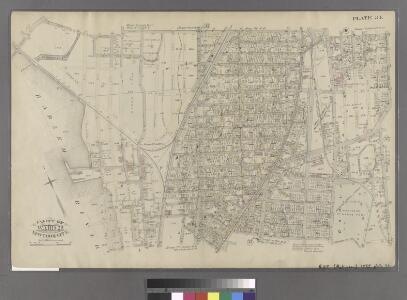
Part of Ward 23, New York City.
from Atlas of the city of New York : embracing all territory within its corporate limits from official records, private plans & actual surveys / by and under the supervision of E. Robinson & R.H. Pidgeon, civil engineers.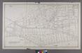
Section 7 of Final Maps and Profiles, of the 23rd & 24th Wards.
from Maps or plans and profiles, with field notes and explanatory remarks, showing the location, width, grades, and class of streets, roads, avenues, public squares and places, located and laid out by the Commissioner of Street Improvements of the 23rd and 24th wards of the city of New York : under authority of Chapter 545 of the laws of 1890.
Section 1 of Final Maps and Profiles, of the 23rd & 24th Wards.
from Maps or plans and profiles, with field notes and explanatory remarks, showing the location, width, grades, and class of streets, roads, avenues, public squares and places, located and laid out by the Commissioner of Street Improvements of the 23rd and 24th wards of the city of New York : under authority of Chapter 545 of the laws of 1890.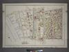
Plate 3: Part of Section 9, Borough of the Bronx. [Bounded by E. 149th Street, Morris Avenue, E. 148th Street, Willis Avenue, E. 139th Street, Third Avenue, E. 138th Street, Exterior Street and River Avenue.]
from Atlas and owners names, borough of the Bronx, sections 9 & 10 : from actual surveys and official plans / by George W. and Walter S. Bromley.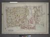
Plate 7: Part of Sections 9&10, Borough of the Bronx. [Bounded by E. 156th Street, Trinity Avenue, E. 149th Street, St Anns Avenue, E. 147th Street, Willis Avenue, E. 148th Street and Morris Avenue.]
from Atlas and owners names, borough of the Bronx, sections 9 & 10 : from actual surveys and official plans / by George W. and Walter S. Bromley.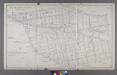
Map or Plan of Section 6. [Bounded by Courtlandt Avenue, New York and Harlem Railroad, E. 168th Street, Prospect Avenue and Westchester Avenue.]
from Maps or plans and profiles, with field notes and explanatory remarks, showing the location, width, grades, and class of streets, roads, avenues, public squares and places, located and laid out by the Commissioner of Street Improvements of the 23rd and 24th wards of the city of New York : under authority of Chapter 545 of the laws of 1890.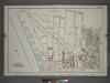
Plate 8: Part of Section 9, Borough of the Bronx. [Bounded by E. 157th Street, Walton Avenue, E. 158th Street, Sheridan Avenue, E. 156th Street, Morris Avenue, E. 149th Street, and (Harlem river Piers) Exterior Street.]
from Atlas and owners names, borough of the Bronx, sections 9 & 10 : from actual surveys and official plans / by George W. and Walter S. Bromley.
Plate 5: Map No. 375 [Bounded by Fourth Avenue, Riverside Avenue, Macomb Avenue, Cottage Street, Morris Avenue, 3rd Avenue and 129th Street.] - Map No. 213 [Bounded by Cherry Street, Old Harlem Bridge Post Road from New York to Boston, Harlem River and N
from Certified copies of important maps appertaining to the 23rd and 24th wards, City of New York, filed in the Register's office at White Plains, County of Westchester, New York ...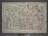
Plate 12: Part of Sections 9&10, Borough of the Bronx. [Bounded by E. 164th Street, Park Avenue, E. 165th Street, Caldwell Avenue, E. 156th Street, Morris Avenue, E. 161st Street and Sheridan Avenue.]
from Atlas and owners names, borough of the Bronx, sections 9 & 10 : from actual surveys and official plans / by George W. and Walter S. Bromley.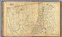
35. Ward 23.
1 : 4800 G.W. Bromley & Co.; Geo. W. Bromley & E. Robinson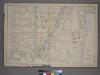
Plate 5: [Bounded by E. 154th St., Brook Ave., Westchester Ave., St. Anns Ave., E. 145th St., N. Third Ave., E. 145th St., College Ave.,E. 144th St. and Morris Ave.]
from Atlas of the city of New York : from official records, private plans & actual surveys / compiled under the supervision of E. Robinson & R. H. Pidgeon.
Plate 1: Map No. 441 [Bounded by Fourth Avenue, 138th Street, ... (Harlem River) Line of Water Grant, Bulkhead & Pier Line, Grove Street, Cottage Street, Old Boston Post Road or Morris Avenue.]
from Certified copies of important maps appertaining to the 23rd and 24th wards, City of New York, filed in the Register's office at White Plains, County of Westchester, New York ...
Sackersdorff Farm set.
from Maps of farms commonly called the Blue book, 1815 : drawn from the original on file in the street commissioner's office in the City of New York, together with lines of streets and avenues / laid out by John Randel, jr., 1819-20.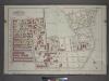
Plate 4: Part of Sections 9&10, Borough of the Bronx. [Bounded by E. 147th Street, Trinity Avenue, Dater Street, Southern Boulevard, E. 138th Street, Brook Avenue, E. 139th Street and Willis Avenue.]
from Atlas and owners names, borough of the Bronx, sections 9 & 10 : from actual surveys and official plans / by George W. and Walter S. Bromley.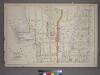
Plate 4: [Bounded by Cromwell Ave., E. 150th St., River Ave., E. 149th St., Gerard Ave., E. 144th St., Morris Ave., E. 154th St. Railroad Ave. East, E. 153rd St., Railroad Ave. West, and Sedgwick Ave.]
from Atlas of the city of New York : from official records, private plans & actual surveys / compiled under the supervision of E. Robinson & R. H. Pidgeon.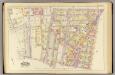
5, ward 23.
1 : 1800 Bromley, George Washington; Bromley, Walter Scott; G.W. Bromley & Co.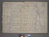
Plate 6: [Bounded by E. 162nd St., Courtland Ave., E. 163rd St., Brook Ave., N. Third Ave., St. Anns Ave., Carr St., German Pl., E. 156th St., N. Third Ave., E. 154th St. and Sherman Ave.]
from Atlas of the city of New York : from official records, private plans & actual surveys / compiled under the supervision of E. Robinson & R. H. Pidgeon.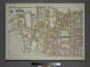
Plate 4, Part of Section 9, Borough of the Bronx. [Bounded by E. 141st Street, E. 142nd Street, Alexander Avenue, E. 135th Street, and Exterior Street.]
from Atlas of borough of the Bronx, Sections 9 10 11 12 & 13 : from actual surveys and official plans / G.W. Bromley and Co.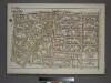
Plate 8, Part of Section 9, Borough of the Bronx. [Bounded by E. 149th Street, St. Anns Avenue, E. 142nd Street, Third Avenue, E. 141st Street and Morris Avenue.]
from Atlas of borough of the Bronx, Sections 9 10 11 12 & 13 : from actual surveys and official plans / G.W. Bromley and Co.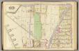
6, ward 23.
1 : 1800 Bromley, George Washington; Bromley, Walter Scott; G.W. Bromley & Co.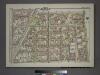
Plate 13, Part of Section 9, Borough of the Bronx. [Bounded by E. 163rd Street, St. Anns Avenue, E. 149th Street and Morris Avenue.]
from Atlas of borough of the Bronx, Sections 9 10 11 12 & 13 : from actual surveys and official plans / G.W. Bromley and Co.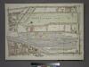
Plate 11, Part of Section 9, Borough of the Bronx. [Bounded by Gerard Avenue, E. 161st Street, Morris Avenue and E. 150th Street.]
from Atlas of borough of the Bronx, Sections 9 10 11 12 & 13 : from actual surveys and official plans / G.W. Bromley and Co.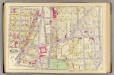
7, ward 23.
1 : 1800 Bromley, George Washington; Bromley, Walter Scott; G.W. Bromley & Co.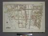
Plate 9, Part of Section 10, Borough of the Bronx. [Bounded by E. 150th Street, Morris Avenue, E. 141st Street, Park Avenue, E. 144th Street, Mott Avenue, E. 140th Street, Gerard Avenue and Exterior Street.]
from Atlas of borough of the Bronx, Sections 9 10 11 12 & 13 : from actual surveys and official plans / G.W. Bromley and Co.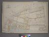
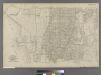
Part of the 23rd Ward, New York City.
from Atlas of the city of New York : from official records, private plans & actual surveys / compiled under the supervision of E. Robinson & R. H. Pidgeon.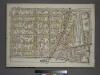
Plate 12, Part of Section 9, Borough of the Bronx. [Bounded by E. 156th Street, St. Anns Avenue, E. 149th Street and Morris Avenue.]
from Atlas of borough of the Bronx, Sections 9 10 11 12 & 13 : from actual surveys and official plans / G.W. Bromley and Co.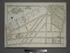
Plate 10, Part of Section 9, Borough of the Bronx. [Bounded by E. (Harlem River Piers) Exterior Street, Jerome Avenue, E. 161st Street, Gerard Avenue and E. 150th Street.]
from Atlas of borough of the Bronx, Sections 9 10 11 12 & 13 : from actual surveys and official plans / G.W. Bromley and Co.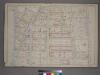
Part of the 23rd Ward, New York City.
from Atlas of the city of New York : from official records, private plans & actual surveys / compiled under the supervision of E. Robinson & R. H. Pidgeon.
[Plate 31: Bounded by W. 145th Street, (Harlem River) Fifth Avenue, W. 139th Street and Lenox Avenue]
from Atlas of the city of New York, borough of Manhattan / from actual surveys and official plans by George W. and Walter S. Bromley.