Maps of Bronx County
7, ward 23.
1 : 1800 Bromley, George Washington; Bromley, Walter Scott; G.W. Bromley & Co.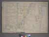
Plate 5: [Bounded by E. 154th St., Brook Ave., Westchester Ave., St. Anns Ave., E. 145th St., N. Third Ave., E. 145th St., College Ave.,E. 144th St. and Morris Ave.]
from Atlas of the city of New York : from official records, private plans & actual surveys / compiled under the supervision of E. Robinson & R. H. Pidgeon.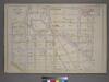
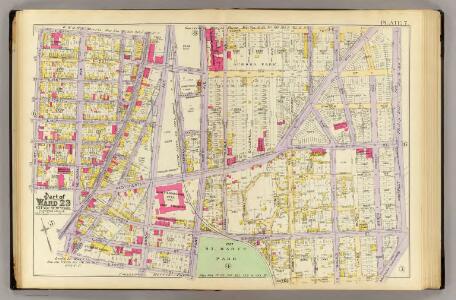
Plate 7: [Bounded by St. Anns Ave., John St., Eagle Ave., Cedar Place, Prospect Ave., Southern Blvd., E. 147th St., Trinity Ave. and E. 149th St.]
from Atlas of the city of New York : from official records, private plans & actual surveys / compiled under the supervision of E. Robinson & R. H. Pidgeon.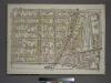
Plate 12, Part of Section 9, Borough of the Bronx. [Bounded by E. 156th Street, St. Anns Avenue, E. 149th Street and Morris Avenue.]
from Atlas of borough of the Bronx, Sections 9 10 11 12 & 13 : from actual surveys and official plans / G.W. Bromley and Co.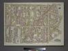
Plate 23, Part of Section 10, Borough of the Bronx. [Bounded by E. 161st Street, Hewitt's Place, Longwood Avenue, Dawson Street, Leggett Avenue, Kelly Street, E. 152nd Street, and St. Anns Avenue.]
from Atlas of borough of the Bronx, Sections 9 10 11 12 & 13 : from actual surveys and official plans / G.W. Bromley and Co.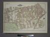
Plate 24, Part of Section 10, Borough of the Bronx. [Bounded by E. 152nd Street, Kelly Street, Avenue St. John, Southern Boulevard, E. 149th Street, Austin Place, E. 147th Street (Dater Street), Trinity Avenue, E. 149th Street and St. Anns Avenue.]
from Atlas of borough of the Bronx, Sections 9 10 11 12 & 13 : from actual surveys and official plans / G.W. Bromley and Co.
Bronx, V. 9, Plate No. 48 [Map bounded by Willis Ave., E. 147th St., Brook Ave., E. 144th St.]
From Atlas 45. Vol. 9, 1908.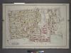
Plate 7: Part of Sections 9&10, Borough of the Bronx. [Bounded by E. 156th Street, Trinity Avenue, E. 149th Street, St Anns Avenue, E. 147th Street, Willis Avenue, E. 148th Street and Morris Avenue.]
from Atlas and owners names, borough of the Bronx, sections 9 & 10 : from actual surveys and official plans / by George W. and Walter S. Bromley.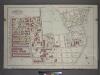
Plate 4: Part of Sections 9&10, Borough of the Bronx. [Bounded by E. 147th Street, Trinity Avenue, Dater Street, Southern Boulevard, E. 138th Street, Brook Avenue, E. 139th Street and Willis Avenue.]
from Atlas and owners names, borough of the Bronx, sections 9 & 10 : from actual surveys and official plans / by George W. and Walter S. Bromley.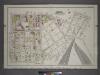
Plate 6: Part of Section 10, Borough of the Bronx. [Bounded by E. 156th Street, Southern Boulevard, Longwood Avenue, Garrison Street, Whitlock Street, Austin Place, E. 149th Street, Timpson Place, E. 147th Street, Union Avenue, Dater Street and Trinity A
from Atlas and owners names, borough of the Bronx, sections 9 & 10 : from actual surveys and official plans / by George W. and Walter S. Bromley.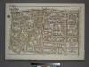
Plate 8, Part of Section 9, Borough of the Bronx. [Bounded by E. 149th Street, St. Anns Avenue, E. 142nd Street, Third Avenue, E. 141st Street and Morris Avenue.]
from Atlas of borough of the Bronx, Sections 9 10 11 12 & 13 : from actual surveys and official plans / G.W. Bromley and Co.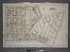
Plate 14: Part of Section 10, Borough of the Bronx. [Bounded by E. 165th Street, Rogers Place, Dongan Street, Southern Boulevard, E. 156th Street and Cauldwell Avenue.]
from Atlas and owners names, borough of the Bronx, sections 9 & 10 : from actual surveys and official plans / by George W. and Walter S. Bromley.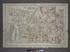
Plate 12: Part of Sections 9&10, Borough of the Bronx. [Bounded by E. 164th Street, Park Avenue, E. 165th Street, Caldwell Avenue, E. 156th Street, Morris Avenue, E. 161st Street and Sheridan Avenue.]
from Atlas and owners names, borough of the Bronx, sections 9 & 10 : from actual surveys and official plans / by George W. and Walter S. Bromley.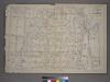
Plate 6: [Bounded by E. 162nd St., Courtland Ave., E. 163rd St., Brook Ave., N. Third Ave., St. Anns Ave., Carr St., German Pl., E. 156th St., N. Third Ave., E. 154th St. and Sherman Ave.]
from Atlas of the city of New York : from official records, private plans & actual surveys / compiled under the supervision of E. Robinson & R. H. Pidgeon.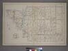
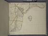
Part of the 23rd Ward, New York City.
from Atlas of the city of New York : from official records, private plans & actual surveys / compiled under the supervision of E. Robinson & R. H. Pidgeon.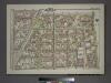
Plate 13, Part of Section 9, Borough of the Bronx. [Bounded by E. 163rd Street, St. Anns Avenue, E. 149th Street and Morris Avenue.]
from Atlas of borough of the Bronx, Sections 9 10 11 12 & 13 : from actual surveys and official plans / G.W. Bromley and Co.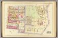
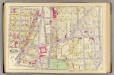
4, ward 23.
1 : 1800 Bromley, George Washington; Bromley, Walter Scott; G.W. Bromley & Co.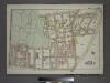
Plate 7, Part of Section 10, Borough of the Bronx. [Bounded by E. 147th Street, Southern Boulevard, E. 147th Street, Austin Place, 149th Street, Whitlock Avenue, E. 141st Street and (St.Mary's Park) St. Anns Avenue.]
from Atlas of borough of the Bronx, Sections 9 10 11 12 & 13 : from actual surveys and official plans / G.W. Bromley and Co.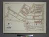
Plate 26, Part of Section 10, Borough of the Bronx. [Bounded by Southern Boulevard, Avenue St. John, Kelly Street, Leggett Avenue, Dawson Street, Longwood Avenue, Garrison Avenue, Leggett Avenue, Whitlock Avenue and E. 149th Street.]
from Atlas of borough of the Bronx, Sections 9 10 11 12 & 13 : from actual surveys and official plans / G.W. Bromley and Co.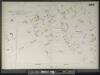
Bronx, V. 9, Double Page Plate No. 200 [Map bounded by Concord Ave., East 149th St., Whitlock Ave., East 142nd St.]
From Atlas 42.59. Vol. 9, 1891.
Bronx, V. 14, Plate No. 55 [Map bounded by E. 163rd St., Dawson St., E. 156th St., Prospect Ave.]
From Atlas 52. Vol. 14, 1901.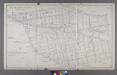
Map or Plan of Section 6. [Bounded by Courtlandt Avenue, New York and Harlem Railroad, E. 168th Street, Prospect Avenue and Westchester Avenue.]
from Maps or plans and profiles, with field notes and explanatory remarks, showing the location, width, grades, and class of streets, roads, avenues, public squares and places, located and laid out by the Commissioner of Street Improvements of the 23rd and 24th wards of the city of New York : under authority of Chapter 545 of the laws of 1890.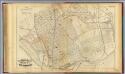
34. Ward 23.
1 : 4800 G.W. Bromley & Co.; Geo. W. Bromley & E. Robinson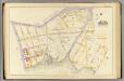
3, ward 23.
1 : 1800 Bromley, George Washington; Bromley, Walter Scott; G.W. Bromley & Co.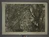
6B - N.Y. City (Aerial Set).
from Sectional aerial maps of the City of New York / [photographed and assembled under the direction of the chief engineer, July 1st, 1924].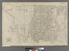
Part of Ward 23, New York City.
from Atlas of the city of New York : embracing all territory within its corporate limits from official records, private plans & actual surveys / by and under the supervision of E. Robinson & R.H. Pidgeon, civil engineers.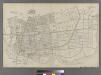
Part of Ward 23, New York City.
from Atlas of the city of New York : embracing all territory within its corporate limits from official records, private plans & actual surveys / by and under the supervision of E. Robinson & R.H. Pidgeon, civil engineers.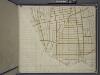
Bronx, Topographical Map Sheet 14; [Map bounded by 154th St., Grove St., Westchester Ave., Robbins Ave.; Including Powers Ave., Cypress Ave., Harlem River, 126th St., 6th Ave.]
From Topographical map made from surveys by the commissioners of the Department of Public Parks of the City of New York of that part of Westchester County adjacent to the City and County of New York embraced by chapter 534 of laws of 1871 as amended b...
Bronx, Topographical Map Sheet 11; [Map bounded by Union Ave., Tinton Ave., Westchester Ave., Eacle Ave., St. Ann's Ave., Rae St., Cerman PL., Brook Ave., Bercen Ave., 3rd Ave.; Including 153rd St., Rail Road Ave. East, Sheridan Ave., Mott Ave., Walto...
From Topographical map made from surveys by the commissioners of the Department of Public Parks of the City of New York of that part of Westchester County adjacent to the City and County of New York embraced by chapter 534 of laws of 1871 as amended b...