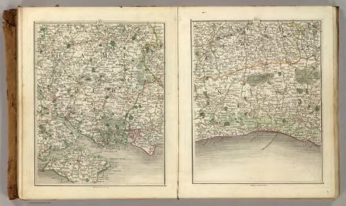
Maps of West Sussex
Sheets 15-16. (Cary's England, Wales, and Scotland).
1 : 360000 Cary, John, ca. 1754-1835
HANTONIA | SIVE | SOVTHANTONENSIS | COMITATVS | Vulgo | HANT-SHIRE.
[Amsterdam : Joan Blaeu]
Hantonia, sive Southantonensis Comitatus, vulgo Hantshire.

Bacon's twentieth century map of Hampshire
1 : 125000 titelvariant: Bacon's new map of Hampshire; Annotatie: Omslagtitel: Bacon's new map of Hampshire; Met plaatsnamenregister en afstandentabel London : Bacon
Sussex, Sheet 32 - Bartholomew's "Half Inch to the Mile Maps" of England & Wales
1 : 126720 Topographic maps Bartholomew, John George John Bartholomew & Co
Suthsexia vernacule Sussex
1 Karte : Kupferdruck ; 36 x 49 cm Valck; Schenk apud Gerardum Valk et Petrum Schenk
Svthsexia; vernacule Svssex
1 Karte : Kupferdruck ; 37 x 51 cm Blaeu Joan Blaeu
Brighton and Worthing - OS One-Inch Map
1 : 63360 Topographic maps Ordnance Survey Ordnance Survey
Chichester - OS One-Inch Map
1 : 63360 Topographic maps Ordnance Survey Ordnance Survey
Hantonia sive Sovthantonensis comitatvs vulgo Hant-shire
1 Karte : Kupferdruck ; 40 x 48 cm Blaeu Joan Blaeu
To the right honorable the master, wardens & elder brethren of the Trinity House, this chart of Spithead is ... dedicated
1 : 110000 Heather, W. (William) Heather and Williams
Map of Hampshire, including the Isle of Wight, 4
1 Blatt : 53 x 69 cm s.n.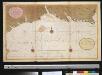
Een gedeelte van het Kanaal van de Hoek van Bevesier tot Bowleij
England Gerard van Keulen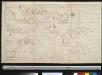
Nieuwe afteekening van de reede van Portsmouth, Spithead en St. Hellens Road aen de Oost zijde vant eijland Wight in het Kanaal
England Johannes van Keulen

London passenger transport map
Ordnance Survey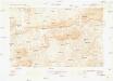
Guildford
1 : 63360 Ordnance Survey Office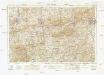
Guildford
1 : 63360 Ordnance Survey Office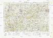
Guildford
1 : 63360 Ordnance Survey Office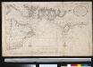
Nieuwe afteekening van de reede van Portsmouth, Spithead en St. Hellens Road aen de Oost zijde vant eijland Wight in het Kanaal
England Gerard van Keulen
Alresford 19
1 : 31680 Relief is indicated on this plan by shading and interlining ('hachuring'). The concern with depicting relief accurately reflects the military emphasis of these drawings: knowledge of the lie of the land could greatly help the efficient movement of regiments. The right-hand side of the drawing is unfinished, featuring main roads only.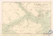
V anglickém průlivu

Vectis insvla. anglice the isle of Wight
1 Karte : Kupferdruck ; 37 x 49 cm Blaeu Joan Blaeu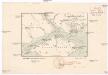
O anglickém průlivu
1 : 290000 Isle of Wight (Anglie) Hanf, Norbert Kořenský, Josef J. Otta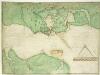
A coloured chart of Portsmouth Harbour, Spithead, and part of the Isle of Wight, on a scale of one mile to an inch
This is a map of Portsmouth and the Isle of Wight dating from 1585. It has been annotated by William Cecil Lord Burghley, Secretary of State to Elizabeth I, who has added the names "Westburhunt" and "Chichest". Burghley was an avid map collector and his application of geographical knowledge to matters of government is well known. Three beacons are indicated on 'Portesdowne', showing the systems in place for alerting the locality in an invasion scenario. Either side of these beacons are red windmill symbols named "westmyll" and "estmill", two further windmills, again highlighted in red, lie towards the centre of the map. It is likely that these have been highlighted due to their height which would facilitate their use as vantage points or beacons. There is a scale bar indicating a scale of one inch to a mile. Portsmouth became the focus of a new program of defensive works in 1584. Since the accession of the Protestant Elizabeth I to the English throne in 1558 Anglo-Spanish relationship had deteriorated. The continued English raids on Spanish colonial interests and England’s support of the Protestant rebellion in the Spanish ruled Netherlands had induced the Catholic Philip II to plan an invasion of England. It is likely that this map, detailing the beacons in the area, was produced for military purposes connected with the strengthening of the defences for the Portsmouth area against the expected Spanish Invasion. William Cecil, Lord Burghley
Arundel 8
1 : 31680 The Ordnance Survey took particular care in plotting the south coast of England, as this was the area most immediately vulnerable to invasion. This plan notes military barracks at Selsea, Aldwick and Bognor to the bottom right of the plan. Buildings are blocked in red and black ink and infilled at Chichester, in the centre of the plan, and Arundel, at the right. A poor house and pest house are located a considerable distance beyond the boundaries of Chichester.
Cranleigh
1 : 31680 Turnpike roads, shown in faded yellow ochre, run from Guildford at the top of the map to Witley in the centre left and "Aldfold" in the bottom left. Black-ink figures record the mileage along these routes. Tollgates are marked "TG". A dotted symbol depicts the untilled agricultural land that dominate the landscape around the valley of the River Wye, from Guildford to Godalming. The stippling technique commonly used to depict rough pasture is used here for the many heaths and commons of the undulating Surrey lowlands. Budgen, Thomas
The Solent - OS One-Inch Map
1 : 63360 Topographic maps Ordnance Survey Ordnance Survey