Maps of Portsmouth
A coloured chart of Portsmouth Harbour, Spithead, and part of the Isle of Wight, on a scale of one mile to an inch
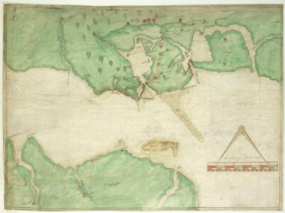
This is a map of Portsmouth and the Isle of Wight dating from 1585. It has been annotated by William Cecil Lord Burghley, Secretary of State to Elizabeth I, who has added the names "Westburhunt" and "Chichest". Burghley was an avid map collector and his application of geographical knowledge to matters of government is well known. Three beacons are indicated on 'Portesdowne', showing the systems in place for alerting the locality in an invasion scenario. Either side of these beacons are red windmill symbols named "westmyll" and "estmill", two further windmills, again highlighted in red, lie towards the centre of the map. It is likely that these have been highlighted due to their height which would facilitate their use as vantage points or beacons. There is a scale bar indicating a scale of one inch to a mile. Portsmouth became the focus of a new program of defensive works in 1584. Since the accession of the Protestant Elizabeth I to the English throne in 1558 Anglo-Spanish relationship had deteriorated. The continued English raids on Spanish colonial interests and England’s support of the Protestant rebellion in the Spanish ruled Netherlands had induced the Catholic Philip II to plan an invasion of England. It is likely that this map, detailing the beacons in the area, was produced for military purposes connected with the strengthening of the defences for the Portsmouth area against the expected Spanish Invasion. William Cecil, Lord Burghley
Portsmouth (Outline) - OS One-Inch Revised New Series
1 : 63360 Topographic maps Ordnance Survey Ordnance Survey
Portsmouth (Hills) - OS One-Inch Revised New Series
1 : 63360 Topographic maps Ordnance Survey Ordnance Survey
Portsmouth
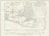
This drawing was surveyed in 1797, The year Napoleon declared that France "must destroy the English monarchy, Or expect itself to be destroyed by these intriguing and enterprising islanders. Let us concentrate all our efforts on the navy and annihilate England. That done, Europe is at our feet." The detail with which the area is surveyed reflects the danger the English establishment felt. The dockyards of Portsmouth, One of most important naval sites in Britain, Are shown by red blocks. The defence fortifications of the area are clearly delineated. South Sea Castle, One of the defensive forts built on the south coast by Henry VIII, Is shown in plan form.
SZ69 - OS 1:25,000 Provisional Series Map
1 : 25000 Topographic maps Ordnance Survey Ordnance Survey
SZ59 - OS 1:25,000 Provisional Series Map
1 : 25000 Topographic maps Ordnance Survey Ordnance Survey
SU60 - OS 1:25,000 Provisional Series Map
1 : 25000 Topographic maps Ordnance Survey Ordnance Survey
SU50 - OS 1:25,000 Provisional Series Map
1 : 25000 Topographic maps Ordnance Survey Ordnance Survey
SZ79 - OS 1:25,000 Provisional Series Map
1 : 25000 Topographic maps Ordnance Survey Ordnance Survey
SU70 - OS 1:25,000 Provisional Series Map
1 : 25000 Topographic maps Ordnance Survey Ordnance Survey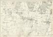
Hampshire & Isle of Wight LXXVI - OS Six-Inch Map
1 : 10560 Topographic maps Ordnance Survey Ordnance Survey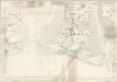
Hampshire & Isle of Wight LXXXIV - OS Six-Inch Map
1 : 10560 Topographic maps Ordnance Survey Ordnance Survey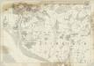
Hampshire & Isle of Wight LXXIV - OS Six-Inch Map
1 : 10560 Topographic maps Ordnance Survey Ordnance Survey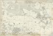
Hampshire & Isle of Wight LXXV - OS Six-Inch Map
1 : 10560 Topographic maps Ordnance Survey Ordnance Survey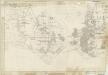
Hampshire & Isle of Wight LXXXIII - OS Six-Inch Map
1 : 10560 Topographic maps Ordnance Survey Ordnance Survey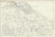
Hampshire & Isle of Wight XC - OS Six-Inch Map
1 : 10560 Topographic maps Ordnance Survey Ordnance Survey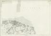
Hampshire & Isle of Wight XCI - OS Six-Inch Map
1 : 10560 Topographic maps Ordnance Survey Ordnance Survey
Sussex LX - OS Six-Inch Map
1 : 10560 Topographic maps Ordnance Survey Ordnance Survey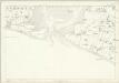
Sussex LXXII - OS Six-Inch Map
1 : 10560 Topographic maps Ordnance Survey Ordnance Survey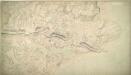
St Helens 27A
1 : 10560 This plan of the Isle of Wight extends from Sandown Bay, At the bottom right, To Haven Street, At the top. The drawing is made on rectangular sheet lines, Enclosed by a black border. Fields are coloured brown where cultivated, And green or blank if untilled. Stonework buildings or structures are drawn in red ink at major settlements like Newchurch and Brading. Infilled or blocked areas of black or sepia ink depict structures or buildings made from impermanent materials such as wood. Coniferous trees are distinguished pictorially from deciduous trees on this map. Gardner, William
Sussex LX.NW - OS Six-Inch Map
1 : 10560 Topographic maps Ordnance Survey Ordnance Survey
Sussex LX.NW - OS Six-Inch Map
1 : 10560 Topographic maps Ordnance Survey Ordnance Survey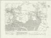
Sussex LX.NW - OS Six-Inch Map
1 : 10560 Topographic maps Ordnance Survey Ordnance Survey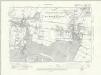
Sussex LX.NW - OS Six-Inch Map
1 : 10560 Topographic maps Ordnance Survey Ordnance Survey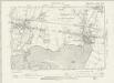
Sussex LX.NW - OS Six-Inch Map
1 : 10560 Topographic maps Ordnance Survey Ordnance Survey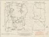
Sussex LX.SW - OS Six-Inch Map
1 : 10560 Topographic maps Ordnance Survey Ordnance Survey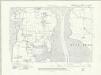
Sussex LX.SW - OS Six-Inch Map
1 : 10560 Topographic maps Ordnance Survey Ordnance Survey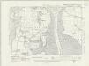
Sussex LX.SW - OS Six-Inch Map
1 : 10560 Topographic maps Ordnance Survey Ordnance Survey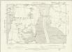
Sussex LX.SW - OS Six-Inch Map
1 : 10560 Topographic maps Ordnance Survey Ordnance Survey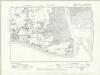
Sussex LXXII.NW - OS Six-Inch Map
1 : 10560 Topographic maps Ordnance Survey Ordnance Survey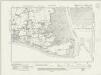
Sussex LXXII.NW - OS Six-Inch Map
1 : 10560 Topographic maps Ordnance Survey Ordnance Survey