Maps of West Sussex

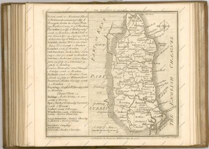
Suthsexia vernacule Sussex
1 Karte : Kupferdruck ; 36 x 49 cm Valck; Schenk apud Gerardum Valk et Petrum Schenk
Svthsexia; vernacule Svssex
1 Karte : Kupferdruck ; 37 x 51 cm Blaeu Joan Blaeu
Suthsexia vernacule Sussex
1 : 240000 Amstelodami : apud Joannem Janssonium
SVTHSEXIA, | Vernacule | SUSSEX.
[Amsterdam : Joan Blaeu]
Sussex, Sheet 32 - Bartholomew's "Half Inch to the Mile Maps" of England & Wales
1 : 126720 Topographic maps Bartholomew, John George John Bartholomew & Co
Sheets 15-16. (Cary's England, Wales, and Scotland).
1 : 360000 Cary, John, ca. 1754-1835
Brighton and Worthing - OS One-Inch Map
1 : 63360 Topographic maps Ordnance Survey Ordnance Survey
Eastbourne - OS One-Inch Map
1 : 63360 Topographic maps Ordnance Survey Ordnance Survey
Chichester - OS One-Inch Map
1 : 63360 Topographic maps Ordnance Survey Ordnance Survey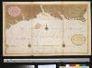
Een gedeelte van het Kanaal van de Hoek van Bevesier tot Bowleij
England Gerard van Keulen
London passenger transport map
Ordnance Survey
London passenger transport map
Ordnance Survey
Arundel 8
1 : 31680 The Ordnance Survey took particular care in plotting the south coast of England, as this was the area most immediately vulnerable to invasion. This plan notes military barracks at Selsea, Aldwick and Bognor to the bottom right of the plan. Buildings are blocked in red and black ink and infilled at Chichester, in the centre of the plan, and Arundel, at the right. A poor house and pest house are located a considerable distance beyond the boundaries of Chichester.
Midhurst 8
1 : 31680 The counties of Hampshire, Surrey and Sussex are separated by a red dashed boundary line in this map of the South Downs and the River Rother Valley. Archaeological details are recorded at Duncton Beacon and Irons Barrow even though such documentation did not become obligatory until 1816. Trees and woodland dominate this undulating landscape. Individual trees with a small vertical stem and a shadow at the base are painstakingly drawn, as well as more general, stippled representations of tree tops en masse. The detailed representation of woodland highlights the military emphasis of the survey: trees could hinder or hide the movement of a regiment. The paper bears the watermark '1903.' Budgen, Charles
East Grinstead 19
1 : 31680 A blue watercolour wash has been used here to describe relief, with the summits of hills left bare. Dense forestation in the area is indicated by rashes of small trees. Main communication routes are coloured buff-yellow, conforming to military cartographic convention. A red pecked line describes the county boundary.
West Grinstead
1 : 31680 The ochre-coloured Roman road, Stane Street, runs from Pulborough at the bottom left of the map to Rudgwick at the top right. Windmills proliferate throughout the area and are represented in elevation. The physical condition of the plan is poor and place names are difficult to read because the manuscript is dirty, worn and ripped. Budgen, Thomas
Tunbridge Wells (Hills) - OS One-Inch Revised New Series
1 : 63360 Topographic maps Ordnance Survey Ordnance Survey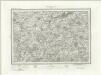
Tunbridge Wells (Outline) - OS One-Inch Revised New Series
1 : 63360 Topographic maps Ordnance Survey Ordnance Survey
Lewes (Hills) - OS One-Inch Revised New Series
1 : 63360 Topographic maps Ordnance Survey Ordnance Survey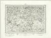
Lewes (Outline) - OS One-Inch Revised New Series
1 : 63360 Topographic maps Ordnance Survey Ordnance Survey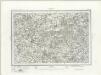
Horsham (Outline) - OS One-Inch Revised New Series
1 : 63360 Topographic maps Ordnance Survey Ordnance Survey
Horsham (Hills) - OS One-Inch Revised New Series
1 : 63360 Topographic maps Ordnance Survey Ordnance Survey
Brighton (Hills) - OS One-Inch Revised New Series
1 : 63360 Topographic maps Ordnance Survey Ordnance Survey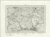
Brighton (Outline) - OS One-Inch Revised New Series
1 : 63360 Topographic maps Ordnance Survey Ordnance Survey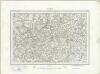
Haslemere (Outline) - OS One-Inch Revised New Series
1 : 63360 Topographic maps Ordnance Survey Ordnance Survey
Haslemere (Hills) - OS One-Inch Revised New Series
1 : 63360 Topographic maps Ordnance Survey Ordnance Survey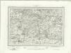
Chichester (Outline) - OS One-Inch Revised New Series
1 : 63360 Topographic maps Ordnance Survey Ordnance Survey
Chichester (Hills) - OS One-Inch Revised New Series
1 : 63360 Topographic maps Ordnance Survey Ordnance Survey