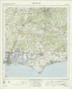
Maps of Chichester

Chichester - OS One-Inch Map
1 : 63360 Topographic maps Ordnance Survey Ordnance Survey
Nieuwe afteekening van de reede van Portsmouth, Spithead en St. Hellens Road aen de Oost zijde vant eijland Wight in het Kanaal
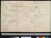
England Johannes van Keulen
Arundel 8
1 : 31680 The Ordnance Survey took particular care in plotting the south coast of England, as this was the area most immediately vulnerable to invasion. This plan notes military barracks at Selsea, Aldwick and Bognor to the bottom right of the plan. Buildings are blocked in red and black ink and infilled at Chichester, in the centre of the plan, and Arundel, at the right. A poor house and pest house are located a considerable distance beyond the boundaries of Chichester.
Midhurst 8
1 : 31680 The counties of Hampshire, Surrey and Sussex are separated by a red dashed boundary line in this map of the South Downs and the River Rother Valley. Archaeological details are recorded at Duncton Beacon and Irons Barrow even though such documentation did not become obligatory until 1816. Trees and woodland dominate this undulating landscape. Individual trees with a small vertical stem and a shadow at the base are painstakingly drawn, as well as more general, stippled representations of tree tops en masse. The detailed representation of woodland highlights the military emphasis of the survey: trees could hinder or hide the movement of a regiment. The paper bears the watermark '1903.' Budgen, Charles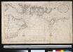
Nieuwe afteekening van de reede van Portsmouth, Spithead en St. Hellens Road aen de Oost zijde vant eijland Wight in het Kanaal
England Gerard van Keulen
Map of Hampshire, including the Isle of Wight, 4
1 Blatt : 53 x 69 cm s.n.
Bognor (Hills) - OS One-Inch Revised New Series
1 : 63360 Topographic maps Ordnance Survey Ordnance Survey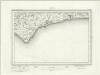
Bognor (Outline) - OS One-Inch Revised New Series
1 : 63360 Topographic maps Ordnance Survey Ordnance Survey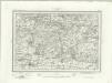
Chichester (Outline) - OS One-Inch Revised New Series
1 : 63360 Topographic maps Ordnance Survey Ordnance Survey
Chichester (Hills) - OS One-Inch Revised New Series
1 : 63360 Topographic maps Ordnance Survey Ordnance Survey
Blendworth
.The county boundary with Sussex is marked on the right edge of this drawing by a black pecked line. Although this drawing predates the obligatory recording of archaeological sites, Roman remains and Rowland's Castle are represented to the bottom right. Ancient burial mounds are marked in many places by a circle and the word 'Tumulas'. Fir trees are marked at Draxford, to the central left of the map, the draughtsman distinguishing between these coniferous trees and deciduous ones. A large compass-drawn circle with a marked radius appears at the top of the drawing. Crocker, Edmund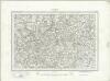
Haslemere (Outline) - OS One-Inch Revised New Series
1 : 63360 Topographic maps Ordnance Survey Ordnance Survey
Haslemere (Hills) - OS One-Inch Revised New Series
1 : 63360 Topographic maps Ordnance Survey Ordnance Survey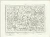
Fareham (Outline) - OS One-Inch Revised New Series
1 : 63360 Topographic maps Ordnance Survey Ordnance Survey
Fareham (Hills) - OS One-Inch Revised New Series
1 : 63360 Topographic maps Ordnance Survey Ordnance Survey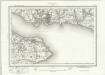
Portsmouth (Outline) - OS One-Inch Revised New Series
1 : 63360 Topographic maps Ordnance Survey Ordnance Survey
Portsmouth (Hills) - OS One-Inch Revised New Series
1 : 63360 Topographic maps Ordnance Survey Ordnance Survey
Portsmouth
This drawing was surveyed in 1797, The year Napoleon declared that France "must destroy the English monarchy, Or expect itself to be destroyed by these intriguing and enterprising islanders. Let us concentrate all our efforts on the navy and annihilate England. That done, Europe is at our feet." The detail with which the area is surveyed reflects the danger the English establishment felt. The dockyards of Portsmouth, One of most important naval sites in Britain, Are shown by red blocks. The defence fortifications of the area are clearly delineated. South Sea Castle, One of the defensive forts built on the south coast by Henry VIII, Is shown in plan form.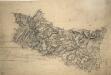
Chiddingfold
1 : 31680 .A turnpike road, coloured ochre yellow, forms a boundary from Hascombe at the top right of the map to 'Aldfold' at the bottom. Common land and dense woodland dominate the region to the left around Hindhead Valley and the Devil's Punchbowl.Commonland is indicated by open dotting. Woods and trees could provide hindrance or cover for the movement of a regiment, so these are recorded in painstaking detail. Individual trees are depicted with a small vertical stem and a shadow at the base. There are also more general representations of groups of treetops. Budgen, Thomas
Selborne
1 : 31680 .Turnpike roads in faded ochre run from Guildford at the top of the map through Witley, at the centre left, on to 'Aldfold' at the bottom left., The mileage appears along the route in black-ink figures., Tollgates are marked 'TG'., Open dotting is used to depict the untilled agricultural land predominant around the river valleys., The hill shading and attention to communication routes conform to the military and cartographic standards employed by the Ordnance Survey. Budgen, Thomas
Alresford 7
Pencil rays radiate from the centre of several circles on this plan. These were used to measure the distance between fixed points in the surveyed area. Calculations are faintly visible on the left edge of the drawing. The paper is watermarked "E & P", Standing for Edmeads and Pine. The numerical annotations running alongside the main road indicate the distance in miles from Alresford to Bishop's Sutton. Like all major communications routes in the Survey, This road is tinted yellow.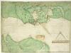
A coloured chart of Portsmouth Harbour, Spithead, and part of the Isle of Wight, on a scale of one mile to an inch
This is a map of Portsmouth and the Isle of Wight dating from 1585. It has been annotated by William Cecil Lord Burghley, Secretary of State to Elizabeth I, who has added the names "Westburhunt" and "Chichest". Burghley was an avid map collector and his application of geographical knowledge to matters of government is well known. Three beacons are indicated on 'Portesdowne', showing the systems in place for alerting the locality in an invasion scenario. Either side of these beacons are red windmill symbols named "westmyll" and "estmill", two further windmills, again highlighted in red, lie towards the centre of the map. It is likely that these have been highlighted due to their height which would facilitate their use as vantage points or beacons. There is a scale bar indicating a scale of one inch to a mile. Portsmouth became the focus of a new program of defensive works in 1584. Since the accession of the Protestant Elizabeth I to the English throne in 1558 Anglo-Spanish relationship had deteriorated. The continued English raids on Spanish colonial interests and England’s support of the Protestant rebellion in the Spanish ruled Netherlands had induced the Catholic Philip II to plan an invasion of England. It is likely that this map, detailing the beacons in the area, was produced for military purposes connected with the strengthening of the defences for the Portsmouth area against the expected Spanish Invasion. William Cecil, Lord Burghley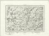
Alresford (Outline) - OS One-Inch Revised New Series
1 : 63360 Topographic maps Ordnance Survey Ordnance Survey
Alresford (Hills) - OS One-Inch Revised New Series
1 : 63360 Topographic maps Ordnance Survey Ordnance Survey
SU93 - OS 1:25,000 Provisional Series Map
1 : 25000 Topographic maps Ordnance Survey Ordnance Survey
SU92 - OS 1:25,000 Provisional Series Map
1 : 25000 Topographic maps Ordnance Survey Ordnance Survey
SU91 - OS 1:25,000 Provisional Series Map
1 : 25000 Topographic maps Ordnance Survey Ordnance Survey
SU83 - OS 1:25,000 Provisional Series Map
1 : 25000 Topographic maps Ordnance Survey Ordnance Survey