Maps of Connecticut

Pas-Kaart vande zee kusten van Niew Nederland anders genaamt Niew York : tusschen Renselaars Hoek en de Staaten Hoek / door C. J. Vooght, geometra.
from Charts and maps
Special -Karte der Vereinigten Staaten von Nord - America No 8.

Delaware, from the best authorities / W. Barker, sculp., Philada.
from Carey's American atlas.
Carte de la Baye et Riviere de Délaware, contenant une éxacte et entiére description des rivages, criques, havres, sondes, bas-sonds, sables et gissements des marques ...
1 : 31000 France. Dépôt des cartes et plans de la marine France. Dépôt des cartes et plans de la marine
New York, New Jersey, Massachusetts, Connecticut, Rhode Island.
1 : 1584000 Smith, J. Calvin
New Iarsey / by John Seller.
from A new system of geography : designed in a most plain and easie method, for the better understanding that science : accommodated with new maps of all the empires, kingdoms, principalities, dukedoms, provinces, and countries in the whole world : with geographical tables, explaining the divisions in each map / by John Seller, late hydrographer to the King.
Part of New England, New York, east New Iarsey and Long Iland.
from Parts
A new map of Virginia, Mary-land and the improved parts of Penn-sylvania & New Jersey / revised by I. Senex.
from Charts and maps I. Senex,
A map of the Province of New York, with part of Pensilvania, and New England.
from Charts and maps
Via RCA, a direct marine radio service to and from ships at sea
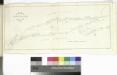
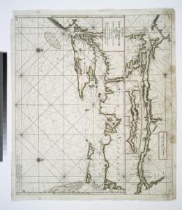
Chart of Long Island Sound, 1822 / Hooker sc.
from The American coast pilot; containing the courses and distances between the principal harbours, capes, and headlands, on the coast of North and South America; with directions for sailing into the same ... with the prevailing winds, setting of the currents, &c., and the latitudes and longitudes of the principal harbours and capes. Together with a tide table. By Edmund M. Blunt. Cor. and improved by information derived from official documents, actual observations, and the most experienced pilots.
Gay Head to Cape Henlopen
1 : 400000 Hassler, F. R.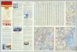
Various Regions and Cities in New England.
Shell Oil Company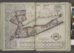
Putman, Rockland, Westchester, New York, Richmond, Kings, Queens, and Suffolk Counties
from New topographical atlas and gazetteer of New York, comprising a topographical view of the several counties of the state, ... including ... map of the United States and territories ... Compiled from the latest astronomical observations, official surveys and records of the United States and territories ...
Connecticut, from the best authorities.
from Carey's general atlas, improved and enlarged : being a collection of maps of the world and quarters, their principal empires, kingdoms, &c.
Connecticut and parts adjacent
1 : 375000 Covens et Mortier et Covens, junior
Patroonships, manors and seigniories in New York recognized by the Order of Colonial Lords of Manors / Max Mayer, Thornwood, N.Y.
Max Mayer, Thornwood,
Connecticut : from the best authorities
1 : 460000 Doolittle, Amos, 1754-1832 Mathew Carey
A map of the state of New Jersey: with part of the adjoining states / compiled under the patronage of the Legislature of said state by Thomas Gordon; engraved by H.S. Tanner, assisted by E.B. Dawson & W. Allen.
from Whole Thomas Gordon; Henry S. Tanner; E.B. Dawson; W. Allen,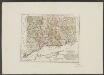
Connecticut
1 : 371000 Sotzmann, D. F Bey Carl Ernst Bohn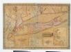
Map of Long Island with the environs of New-York and the southern part of Connecticut / compiled from various surveys & documents by J. Calvin Smith ; engraved & printed by S. Stiles & Co., N. York.
from Long Island
Connecticut.
from The cerographic atlas of the United States. By Sidney E. Morse, A.M., and Samuel Breese, A.M.
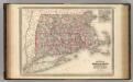
County map of Massachusetts, Connecticut, and Rhode Island.
from New general atlas.
A map of Connecticut.
from The American geography; or, A view of the present situation of the United States of America: containing astronomical geography; geographical definitions, discovery, and general description ... By Jedidiah Morse, A.M.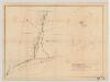
[Map of railroad lines from New York to Springfield, Mass.]
J.H. Bufford & Co Bufford & Co. Lith.
Railroad Map Featuring Many Northeastern States Rhode Island Connecticut Massachusetts
1 : 2000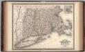
Massachusetts, Connecticut, and Rhode Island.
1 : 660000 Johnson, A.J.
Massachusetts, Connecticut, Rhode Island.
1 : 688000 Finley, Anthony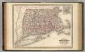
Massachusetts, Connecticut, and Rhode Island.
1 : 660000 Johnson, A.J.